6:34 PM Saturday, April 1, 2023
A little bit of a sneaky system moving in on Sunday which could bring a quick burst of snow or a wintry mix to southern portions of the Northland including the Twin Ports before Noon on Sunday, while some snow or a mix lingers in northern Minnesota, North Shore and Arrowhead Sunday afternoon into Sunday night.
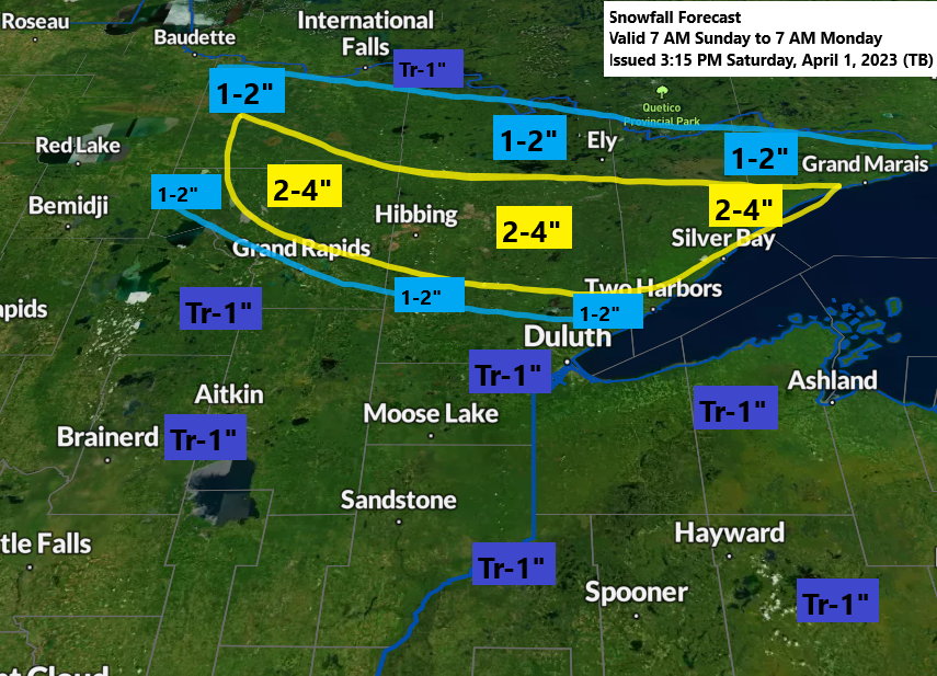
A narrow corridor of higher snow totals which could reach 2 to 4 inches is possible Sunday through early Monday morning north of Duluth, with a trace to 1 inch of snow possible in the Twin Ports on Sunday.

A period of freezing rain or sleet could lead to a light glaze of ice accumulation in parts of the Northland Sunday morning.

Some stronger lift (yellow, orange and red colors on the loop below) moves northeast across northeast Minnesota and northwest Wisconsin for a time on Sunday, and this could lead to some heavier bursts of snow or a wintry mix assuming precipitation can overcome some dry air.
700mb forecast valid 7 AM Sunday to 7 AM Monday.

For Duluth — The best chance for some snow or a mix occurs from around 8 AM to Noon on Sunday.
European model radar forecast valid 7 AM Sunday to 7 AM Monday.
Snow (blue)
Rain (green)
Mix (pink)

Looks like we could have quite a difference in temperature across the region on Sunday with highs ranging from the mid 30s in northeast Minnesota, including the North Shore and Twin Ports to the mid 40s to around 50 degrees from Brainerd east to Moose Lake, south to Hinckley and in all of northwest Wisconsin (inland from the South Shore)
Temperatures as warm as the mid 50s to around 60 degrees on Sunday in far southern/southeast Minnesota into southwest Wisconsin.

Snowfall Reports from the March 31, 2023, Winter Storm
Source: National Weather Service Duluth, Minnesota
2 E Sarona, WI: 9.4″
2 E Butternut, WI: 7.3″
5 NW Winter, WI: 6.5″
4 WSW Northwoods Beach, WI: 5.5″
Trego, WI: 4.0″
From a model perspective, the Euro was pretty much spot on on where the corridor of heavy snow would setup Friday night with a farther south solution shown for several model runs, whereas the GFS and NAM were farther north with the heavier snowfall until those models finally shifted south toward the Euro model, but that took until Thursday night or even as late as Friday morning before that happened.

Tim
Leave a Reply