8:52 PM Saturday, April 15, 2023
A messy/snowy system on the way for Sunday, lingering into Monday in some parts of the Northland.
*Areas of light rain and drizzle in Duluth tonight with steadier precipitation redeveloping Sunday morning around 4-7 AM. Rain is expected to mix with and change to wet snow Sunday morning with snow and possibly some sleet Sunday afternoon. Some snow lingers into Sunday night before ending on Monday. Heaviest snowfall rates in Duluth are expected mainly before Noon on Sunday. With the snow falling during the day Sunday, this could limit how much snow actually accumulates in Duluth due to the warmer ground temperatures and higher sun angle this time of the year. A greater chance for some snow accumulation occurs late Sunday afternoon/night if the snow lingers long enough in the Twin Ports. Note — Duluth needs an additional 3.8 inches of snow to break the seasonal snowfall record of 135.4 inches set in 1995-1996. Not real sure if this storm will be the one to do it but will see what happens.
*The highest snow amounts with this storm are forecast to be northeast and east of Duluth where 4 to 8 inches (possibly more) of total snow accumulation is expected by Monday afternoon, but even in the areas with the higher forecasted snow amounts, there may not be much snow accumulation during the day Sunday, but by late Sunday afternoon through Sunday night into Monday morning this all changes.
*Heavy snowfall rates of 1 inch per hour are possible Sunday through Monday morning in parts of the Northland, favoring the Arrowhead and parts of northwest Wisconsin once we get into Sunday night and Monday morning.
*Areas of blowing snow are likely Sunday afternoon through Monday due to increasing N/NW winds. Occasional whiteout/near whiteout conditions could develop over the Arrowhead and parts of northwest Wisconsin at the height of this winter storm from Sunday afternoon through at least Monday morning.
*Scattered power outages are possible in parts of the Northland due to the strong winds and also in areas that see the most significant snow accumulations since this snow should be rather wet/dense.
*Some sleet and freezing rain is likely on Sunday in parts of northeast and eastern Minnesota and northwest Wisconsin with the greatest ice accumulations forecast to be over far northeast Minnesota and in parts of northwest Wisconsin.
Note: It’s highly unlikely that snow will instantly accumulate once it starts falling Sunday morning due to the recent rainfall and very warm to even hot temperatures that we saw in much of the Northland over the last several days, so the longer it takes for the snow to accumulate the less snow accumulation there likely will be, this is especially true in the 2-4″ and 1-2″ snowfall zones since a lot of the snow in these zones will likely fall during the day Sunday into Sunday evening or during the warmer part of the day, so it’s going to take some real heavy snowfall rates to overcome the warmer ground temps during the day Sunday to allow the snow to begin accumulating and I’m just not sure this will be the case.

ICING POTENTIAL
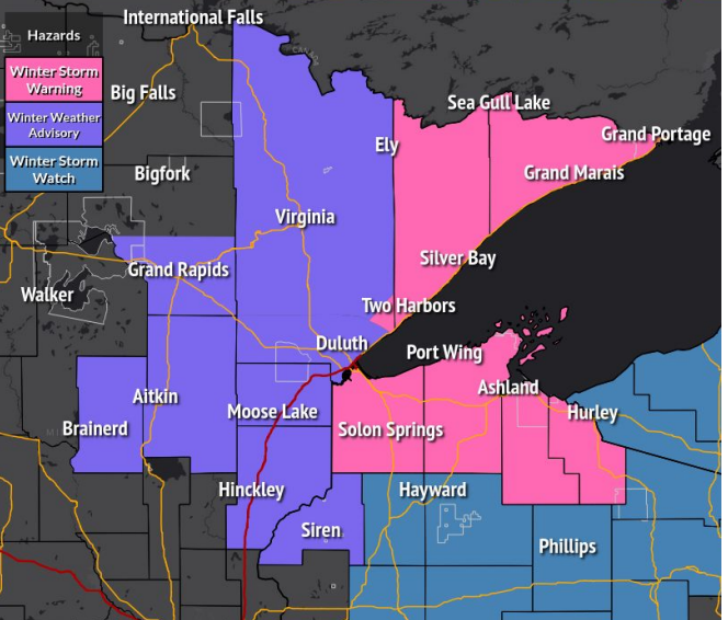
Some freezing rain and sleet is likely in parts of the Northland Sunday and Sunday night with the greatest chances for some ice accumulations over far northeast Minnesota including portions of the North Shore and Arrowhead, and also over parts of northwest Wisconsin (black outlined areas on map) Total ice accumulations in the aforementioned areas could reach 0.05″ to as high as 0.25″.

Note: A light glaze of ice is also possible in Duluth on Sunday with a high-end ice amount of 0.01″ per EPS model forecast.


Areas of light rain, drizzle and snow will be found over parts of the Northland tonight with steadier precipitation redeveloping from south to north Sunday morning. Any rain should switch over to snow or a wintry mix pretty quickly Sunday morning.
Snow continues Sunday afternoon into Sunday night with snow ending from west to east on Monday. Snow will linger the longest in far northeast Minnesota and in northwest Wisconsin, these areas could be getting snow all the way through Monday evening before the snow finally ends later Monday night.
European model radar forecast valid 1 AM tonight to 1 AM Tuesday.
Snow (blue)
Rain (green)
Wintry Mix (orange and pink)

STRONG WINDS
Winds will increase out of the north to northwest on Sunday with gusts of 25 to 45 mph likely with even stronger wind gusts over 50 mph possible over far northeast Minnesota. These strong winds will continue into Monday morning before diminishing Monday afternoon.
HRRR model wind gust forecast valid 7 AM Sunday to 1 PM Monday.

Low pressure over north central Illinois late this afternoon will lift slowly N/NE into southern/eastern portions of Wisconsin on Sunday. Then will see this low move across northern Lower Michigan on Monday.

Along with the surface low is a strong upper-level trough which stretches from the Dakotas to Texas late this afternoon. This trough will deepen while becoming negatively tilted as it swings N/NE through the upper Midwest and Great Lakes through Monday.

In order to get snow or some kind of wintry precipitation you need cold air, and that cold air is currently sitting over western/northern Minnesota where temperatures aloft (850mb) are sitting in the -1 to -4C range, this colder air mass will continue to move farther to the south/east through Sunday.

Surface temperatures are already cold enough for snow in the area outlined in black with temperatures early this evening ranging from 30 to 34 degrees, and these kinds of temperatures are forecast to be over much of the Northland on Sunday.
Also of note are the very warm temperatures which remain over southern and eastern Wisconsin early this evening so there is quite a temperature contrast setting up adding fuel to this developing winter storm.

Tim
Leave a Reply