5:39 PM Tuesday, April 25, 2023
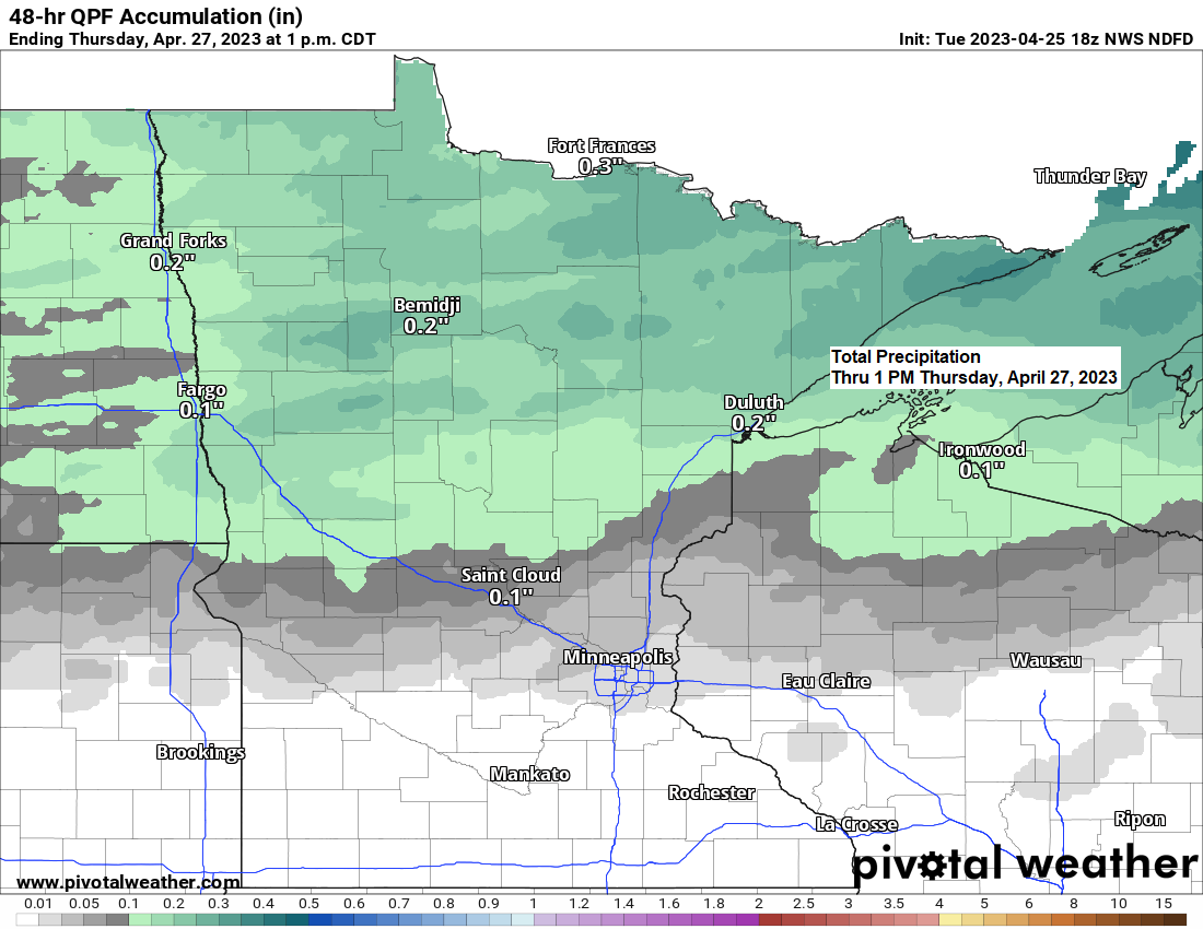
Rain is likely across the Northland Wednesday night as a clipper system moves across the area. Precipitation totals with this system are forecast to range from around 0.10 to 0.35 inches in northeast and east-central Minnesota with around 0.05 to 0.15 inches of precipitation possible in northwest Wisconsin.
Far northeast Minnesota (Arrowhead region) will likely see some wet snow or a rain/snow mix with this system late Wednesday night with up to 2 inches of snow possible in far northeast Minnesota.
Temperatures will finally be warming up the next few days and will be getting back to where they should be in late April with highs Wednesday in the upper 40s to middle 50s, and on Thursday highs are forecast to be in the middle 50s to lower 60s, but this warmth won’t last as cooler temperatures return starting on Friday, and this cool temperature pattern will likely persist at least into early next week.
Timing of the rain for Duluth: Rain begins Wednesday evening between 7 PM-9 PM. Rain ends early Thursday morning between 3 AM-5 AM.
NAM 3km model radar forecast valid 1 PM Wednesday to 7 AM Thursday.
Rain (green)
Snow (blue)

No snow with Wednesday night’s system in Duluth, but there might be some snow in far northeast Minnesota.

Total Precipitation for April 2023 (thru the 24th)
Ashland, WI: 3.54″
Duluth, MN: 2.37″
Brainerd, MN: 2.12″
International Falls, MN: 1.62″
Hibbing, MN: 1.57″

Departure from Normal and Percent of Normal Precipitation for April 2023 (thru the 24th)
Ashland: +1.76″ above normal; 199% of normal
Brainerd: +0.87″ above normal; 170% of normal
Duluth: +0.32″ above normal; 116% of normal
International Falls: +0.31″ above normal; 124% of normal
Hibbing: +0.31″ above normal; 125% of normal

An unsettled weather pattern is expected to linger across the Northland this weekend into early next week as a very amplified pattern continues.
We’re not looking at anything very heavy in terms of the amount of rain or snow in our area this weekend and early next week, but occasional waves of mostly light rain or a rain/snow mix are possible in northeast Minnesota and northwest Wisconsin as a strong and deep upper low/trough sets up to our east.

5-Day Significant River Flood Outlook thru April 30, 2023.
Red – Significant River Flooding Occurring
Orange – Significant River Flooding Likely
Yellow – Significant River Flooding Possible

Tim
Leave a Reply