6:17 PM Tuesday, July 18, 2023
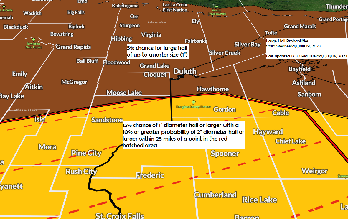
There is a chance for a few strong to severe thunderstorms in northeast Minnesota and northwest Wisconsin for Wednesday into Wednesday evening with the highest chance currently looking to be from east central Minnesota into parts of northwest Wisconsin.
Uncertainty remains, however, regarding how much moisture and instability that’ll be available in our area by Wednesday afternoon, but at the very least we could see dew points climb to around 60 with CAPE of up to 500-1000 J/kg in much of the Northland by Wednesday afternoon-early Wednesday evening. Both values are actually pretty low considering we’re heading into late July, but that just shows you the kind of summer that it’s been in the Northland.
How long the scattered rains stick around for Wednesday morning will play a role on the amount of instability that builds for Wednesday afternoon. If this rain lingers and cloud cover sticks around through much of Wednesday morning, then the amount of instability will probably end up on the low side and generally confined to a pretty narrow corridor meaning that the stronger storms that might develop Wednesday afternoon won’t have much of a chance at holding together the farther east they travel as they move into a more stable air mass.
This system moving through on Wednesday is pretty impressive though with an area of strong winds aloft and some pretty strong forcing which will move through Wednesday afternoon through Wednesday evening so even if we end up with very little severe weather, we should still see some showers and scattered thunderstorms in the Northland.
Primary severe weather threats on Wednesday include…
Large Hail to 1″ in diameter (quarter size) with a chance for a few significant hail events of 2″ in diameter or larger (hen egg size or larger) in eastern Minnesota and parts of northwest Wisconsin.
Damaging wind gusts to 60 mph.
An isolated tornado or two mainly over eastern Minnesota and parts of northwest Wisconsin.

Looking closer at the severe weather ingredients on Wednesday reveals some issues, one being rather weak winds from the surface to a couple thousand feet up in the atmosphere, so the amount of speed shear is less than ideal for severe weather tomorrow with surface winds around 5 to 15 mph, and 850mb winds to around 25 mph, you’d rather see stronger winds from the surface to 850mb which increase from the ground up which we really don’t have for Wednesday’s setup.
Directional shear is present though with south to southwest low-level winds veering west-northwest in the mid-levels of the atmosphere, so this does raise the potential for isolated supercell development and possibly even splitting supercells where one cell tracks northeast while another cell moves south-southeast.
Mid-level lapse rates don’t look overly impressive on Wednesday with values maxing out right around 6.0-7.0 c/km, and with values this low this could help in keeping any hail from getting too large.

System which will move through the Northland on Wednesday looks impressive on satellite imagery this afternoon with a nice swirl in the clouds over southwestern Saskatchewan.
Goes-16 visible satellite loop from Tuesday, July 18, 2023 (loop time ends 4:50 PM CT)

And here’s a look at this low-pressure system via Goes-16 water vapor imagery from Tuesday, July 18, 2023 (loop time ends 4:50 PM CT)

Rainfall Anomalies for July 2023 (thru 4 PM on the 18th)
Brainerd, MN: -2.53″ below normal
Hibbing, MN: -2.36″ below normal
Duluth, MN: -2.12″ below normal
International Falls, MN: -1.70″ below normal
Ashland, WI: -0.63″ below normal
Rainfall totals of a quarter to a half inch or more are possible in northeast Minnesota and northwest Wisconsin Wednesday with lesser amounts of rain over the southwest portion of the Northland (Brainerd area)

It’s been a dry July in much of the area.
Percent of normal rainfall since July 1.
Hibbing, MN: 6% of normal
Brainerd, MN: 7% of normal
Duluth, MN: 14% of normal
International Falls, MN: 34% of normal
Ashland, WI: 71% of normal

Here’s a couple computer model radar forecasts for Wednesday.
HRRRv4

RRFS-A

NAM 3km

Thanks for reading!
Tim
Leave a Reply