5:06 PM Thursday, July 20, 2023
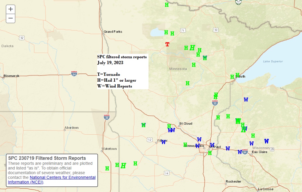
Scattered strong to severe thunderstorms moved through parts of the Northland on Wednesday with numerous reports of large hail to quarter size, along with a few reports of hail as large as golf ball and even baseball size! One funnel cloud was reported near Siren, WI around 5 PM Wednesday.
By far July 19th has been the most active day for severe weather we’ve seen in the Northland so far this summer.
Local Storm Reports from Wednesday, July 19, 2023
Source: National Weather Service Duluth, Minnesota
2:55 PM: Hail 1.00″ (quarter size) 8 S Cohasset, MN (Itasca County)
3:08 PM: Hail 1.00″ (quarter size) 4 S Little Pine, MN (Crow Wing County)
3:49 PM: Hail 0.75″. Floodwood, MN (St. Louis County)
3:50 PM: Hail 1.00″ (quarter size) 3 ENE Inger, MN (Itasca County)
4:05 PM: Hail 1.75″ (golf ball size) 1 NNW Bowstring (Itasca County)
4:06 PM: Hail 0.50″. Marcell, MN (Itasca County)
4:10 PM: Hail 2.50″ (tennis ball size) 2 NW Bowstring, MN (Itasca County)
4:10 PM: Lightning. 5 E Mahtowa, MN (Carlton County) Lightning strike caused barn fire in Blackhoof Township. No injuries or fatalities or other structures impacted, but 100-year-old barn is considered a total loss.
4:15 PM: Hail 0.70″. 3 W Carlton, MN (Carlton County)
4:15 PM: Hail 2.75″ (baseball size) Marcell, MN (Itasca County) Observer reports they have broken windows and a dented car.
4:35 PM: Hail 1.00″ (quarter size) 13 ESE Marcell, MN (Itasca County)
4:45 PM: Hail 0.70″. Sturgeon Lake, MN (Pine County)
4:47 PM: Hail 1.00″ (quarter size) Sturgeon Lake, MN (Pine County)
4:51 PM: Hail 1.00″ (quarter size) 1 ENE Sturgeon Lake, MN (Pine County)
4:52 PM: Hail 1.00″ (quarter size) 3 E Sturgeon Lake, MN (Pine County)
4:53 PM: Hail 1.50″ (ping pong ball size) Willow River, MN (Pine County)
5:01 PM: Funnel Cloud. 1 N Siren, WI (Burnett County)
5:05 PM: Hail 1.50″ (ping pong ball size) Bruno, MN (Pine County)
5:06 PM: Hail 1.25″ (half dollar size) 4 SE Webster, WI (Burnett County)
5:07: Hail 1.00″ (quarter size) Webster, WI (Burnett County)
5:10 PM: Hail 1.75″ (golf ball size) 3 NNE Siren, WI (Burnett County) Ground completely covered with hail.
5:10 PM: Hail 1.75″ (golf ball size) 3 E Siren, WI (Burnett County) Spotter reports that damage occurred to siding and window trim. Roof damage was also reported.
5:15 PM: Hail 1.75″ (golf ball size) 4 SE Webster, WI (Burnett County)
5:15 PM: Hail 1.25″ (half dollar size) 4 SSE Webster, WI (Burnett County)
5:20 PM: Hail 1.25″ (half dollar size) 1 E Sturgeon Lake, MN (Pine County)
5:24 PM: Hail 1.00″ (quarter size) 3 E Siren, WI (Burnett County)
5:33 PM: Hail 1.00″ (quarter size) 12 N Grand Rapids, MN (Itasca County)
5:35 PM: Thunderstorm Wind Damage. 5 E Gordon, WI (Douglas County) Numerous tree branches were reported down with species being primarily white spruce and red pine. Branch size estimated to be around 2 inches in diameter.
5:40 PM: Hail 1.00″ (quarter size) 5 WSW Shell Lake, WI (Washburn County)
5:52 PM: Hail 0.70″. Shell Lake, WI (Washburn County)
5:57 PM: Hail 1.00″ (quarter size) 2 W Sarona, WI (Washburn County)
5:59 PM: Hail 2.00″ (hen egg size) 4 SSW Shell Lake, WI (Washburn County) Hail damage includes severe damage to gardens and trees. Possible damage to cars and roofs.
6:08 PM: Hail 1.50″ (ping pong ball size) 7 S Shell Lake, WI (Washburn County)
6:09 PM: Hail 1.00″ (quarter size) 2 SW Pengilly, MN (Itasca County)
6:09 PM: Thunderstorm Wind Damage. 1 W Pengilly, MN (Itasca County) Report of a tightly rotating mesocyclone and possible wind or tornado damage on Highway 169 approximately 2 miles east of Calumet.
6:10 PM: Thunderstorm Wind Damage. 2 NE Calumet, MN (Itasca County) Several 8 to 10 inch diameter aspen trees down pointing from northwest to southeast.
6:12 PM: Hail 1.00″ (quarter size) 3 WNW Grantsburg, WI (Burnett County)
6:15 PM: Thunderstorm Wind Damage. 1 S Pengilly, MN (Itasca County) Small 5 inch diameter tree down blown down facing west.
6:55 PM: Hail 0.75″. 2 WSW Hermantown, MN (St. Louis County)
7:00 PM: Hail 1.00″ (quarter size) NWS Duluth, MN (St. Louis County) Numerous hailstones with the largest stones up to quarter size.
7:00 PM: Hail 1.00″ (quarter size) 1 NNE Hermantown, MN (St. Louis County)
7:15 PM: Hail 1.00″ (quarter size) 3 NNE Lester Park, MN (St. Louis County)
Some locations north of Duluth got a lot of rain on Wednesday with amounts of 1 to 2 inches reported.

Rainfall Reports from July 19, 2023
Source: National Weather Service Duluth, Minnesota
1 SW Buhl, MN: 2.38″
1 NW Chisholm, MN: 2.22″
8 NNW Bovey, MN: 1.80″
5 SSE Mckinley, MN: 1.70″
1 ESE Nashwauk, MN: 1.67″
2 ESE Mountain Iron, MN: 1.52″
Keewatin, MN: 1.42″
7 SSW Hoyt Lakes, MN: 1.42″
4 NW French River, MN: 1.38″
2 ESE Floodwood, MN: 1.30″
1 NW International Falls, MN: 1.27″
4 N Moose Lake, MN: 1.21″
Cloquet, MN: 1.19″
3 E Sawyer, MN: 1.18″
3 WSW Cloquet, MN: 1.13″
Embarrass, MN: 1.12″
3 E Orr, MN: 1.01″
Coleraine, MN: 1.00″
Duluth Airport: 0.65″
Ashland, WI: 0.25″
Brainerd, MN: 0.06″
Note – Hibbing, Minnesota broke their 24-hour precipitation record on July 19th with a rainfall total yesterday of 2.31″, this broke the previous record of 1.47″ which was set in 1945.
Thanks for reading!
Tim
Leave a Reply