6:24 PM Monday, July 31, 2023
There is a chance that we could see some showers and thunderstorms move south/southeast across parts of the Northland for Tuesday and Tuesday night with the greatest chances for some rain found over western/northwest portions of the area, or west of a line from around Ely to Floodwood to Aitkin.
Isolated storms could redevelop Wednesday, and then a more organized system could move across the area sometime this weekend or early next week bringing more rain to all or parts of the Northland.
Isolated strong to severe storms are possible Tuesday in north central Minnesota with large hail to quarter size and damaging winds to 60 mph being the primary severe weather threats. Note — There is a greater risk of severe storms Tuesday in northwest Minnesota (yellow area on map)

Computer models are not in very good agreement with the placement of Tuesday’s rain with the HRRR model (shown below) showing the rain reaching much farther east later in the day, passing through the Twin Ports around 5 PM-7 PM Tuesday.

While the Nam 3km model (shown below) is much drier with only widely scattered showers and thunderstorms across the area Tuesday with mainly dry conditions in the Twin Ports.

NWS Blend of models keeps the rain west of the Twin Ports Tuesday.
Rainfall forecast through 1 AM Wednesday.

It’s been a dry July in much of the Northland, here’s a look at total rainfall and the departure from normal and percent of normal rainfall for July 2023.
Brainerd, Minnesota
Total: 0.67″
Departure: -3.68″ below normal
Percent of normal rainfall: 15% of normal
Note — July 2023 ranks as the 3rd driest July on record at Brainerd. The driest July on record occurred in 1948 with 0.38″ of rain.
Duluth, Minnesota
Total: 1.37″
Departure: -2.55″ below normal
Percent of normal rainfall: 35% of normal
Hibbing, Minnesota
Total: 2.67″
Departure: -1.18″ below normal
Percent of normal rainfall: 70% of normal
International Falls, Minnesota
Total: 2.75″
Departure: -1.22″ below normal
Percent of normal rainfall: 70% of normal
There have been pockets of above average rainfall (green and purple colors) this month across the Northland, but for the most part rainfall has been below average in much of the area (red colors)

Temperature anomalies in the Northland for July 2023 (thru the 30th)
Hibbing, MN: -2.1 degrees below normal
Duluth, MN: -1.6 degrees below normal
Brainerd, MN: -1.3 degrees below normal
International Falls, MN: -1.3 degrees below normal
Ashland, WI: -0.8 degrees below normal
Note — 9 days this month with a high of at least 80 at Duluth. Average number of days with a high of at least 80 in Duluth in July is 12 days.
***July 2023 ranks as the 4th coolest July on record at Hibbing. The coldest July on record at Hibbing occurred in 2009 with an average temperature of 58.8 degrees***

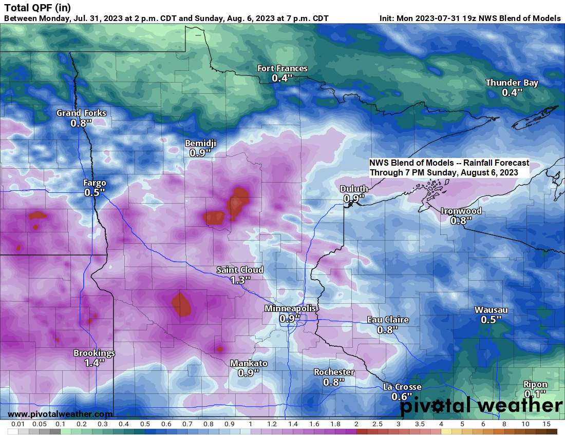
As we get into the Friday-Sunday time frame we see another potential system (outlined in black) approaching from the west, and this one could cause a fairly widespread rain event in the Northland sometime this weekend, but since this system is still a couple days away, we could see the track, timing, and strength of this system change a bit in the computer models over the next few days.

Thanks for reading!
Tim
Leave a Reply