4:21 PM Thursday, August 17, 2023
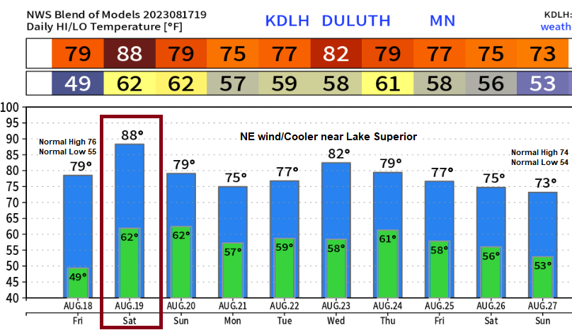
A one-day warm wave ahead in Duluth and this occurs on Saturday with temperatures possibly climbing into the upper 80s, otherwise we’re looking at highs which will mostly be in the 70s to around 80 for the next 10 days while a northeast wind with even cooler temps occurs at times near Lake Superior especially as we get into next week.
A significant and long-lasting heat wave continues to look likely this weekend into much of next week across the Midwest, but it still looks like the core of the most intense heat as well as the most persistent heat will setup well south of northeast Minnesota and northwest Wisconsin next week with cooler temperatures for much of the Northland, especially near Lake Superior where we should see several days of cooler northeast winds next week.
The GFS model from today shows a very impressive upper-level ridge next week with 500mb heights running +3 to +4 standard deviations (darker red and orange on the map below)

But as I pointed out above, it still looks like the Northland will miss out on this heat wave next week with temperatures actually running slightly below average near Lake Superior, to near to slightly above average across the rest of the Northland.

GEFS model temperature anomaly trend for next week (Aug. 21-26, 2023)
Orange and reds: Above average temperatures
Blues: Below average temperatures

The pattern ahead looks quite dry across the Northland, although we could see a few showers or thunderstorms develop at times next week as our area will remain on the north side of where a strong upper-level ridge will be setting up.

***DROUGHT UPDATE***
Data as of August 15, 2023.
Minnesota
1% of the state is in Extreme Drought, down from 2% last week.
22% of the state is in Severe Drought, down from 33% last week.
72% of the state is in Moderate Drought, down from 79% last week.
99% of the state is Abnormally Dry, down from 100% last week.

Wisconsin
0.66% of the state is in Exceptional Drought, up from 0.32% last week.
11% of the state is in Extreme Drought, down from 17% last week.
42% of the state is in Severe Drought, down from 47% last week.
78% of the state is in Moderate Drought, down from 82% last week.
96% of the state is Abnormally Dry, down from 97% last week.

There has been some slight improvement in the drought in parts of the Northland over the last 2 weeks.
Green areas: 1 class improvement.
Yellow areas: 1 class degradation.

Much of northeast Minnesota and all of northwest Wisconsin needs an additional 6 to 9 inches of precipitation to eliminate the current drought over the area.

***WILDFIRE SMOKE***
More wildfire smoke will impact the Northland through Friday, and possibly even into this weekend, although the heaviest smoke which will continue to mix down to the surface will occur through Friday with some improvement possible this weekend.
Here’s the HRRR model smoke forecast through 7 AM Saturday.

Air Quality Alert is in effect until 11 PM Friday for the area in orange on the map below.

Thanks for reading!
Tim
Leave a Reply