6:23 PM Tuesday, August 29, 2023
The big weather story around here will be the upcoming warm up which could be pretty significant in that we could even see some record-breaking warmth this weekend into early next week.
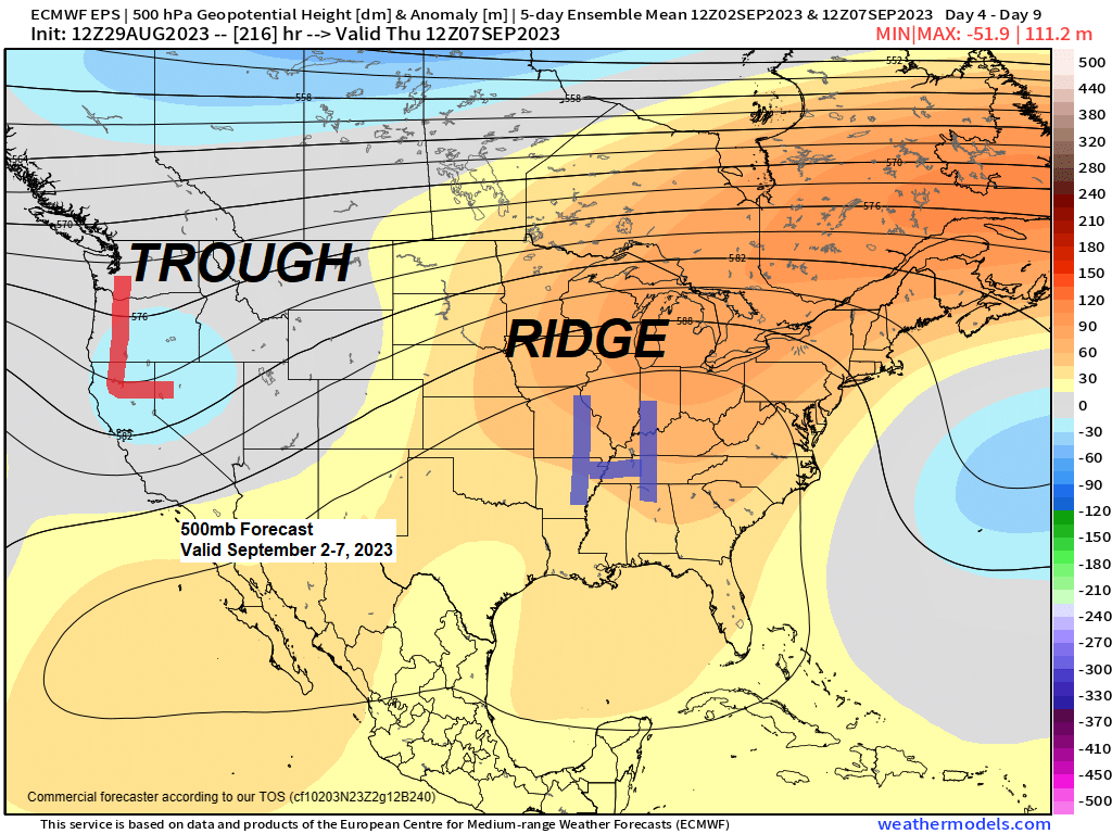
The basic pattern this weekend into the middle of next week will consist of an upper-level trough over the western US, while a large upper-level ridge stretches from the southern US to the Midwest and Ohio Valley. This pattern configuration will setup a southwest flow aloft across the upper Midwest with plenty of very warm air building north into the region.
There is a chance that we could see at least one day with 90-degree temperatures in the Northland including in Duluth between September 2nd-4th, and some parts of the area could see multiple days of 90-degree temps during the aforementioned time frame.
Getting a temperature of at least 90 degrees in September in Duluth doesn’t happen very often, in fact one has to go back to September 19th, 1984, to find the last time Duluth recorded a temperature of at least 90 degrees in September, and out of the 149 years of weather records for Duluth, only 11 years have seen a temperature of 90 degrees in September, those years include, 1984, 1983, 1978, 1976, 1961, 1947, 1931, 1929, 1894, 1891 and 1874.
Note — The last time Duluth recorded a temperature of at least 90 degrees was back on July 18th, 2022.
***RECORD HIGHS FOR DULUTH FOR SEPTEMBER 2ND-4TH***
9/2: 92 degrees set in 1983.
9/3: 89 degrees set in 1960.
9/4: 89 degrees set in 1897.
Here’s a look at the NWS Blend of Models temperature forecast for Duluth for September 1st-5th — Record or near record warmth is possible this weekend.

Both the EPS and GEFS models continue to be in very good agreement on this upcoming warm spell late this week into at least early next week, and it may even continue deeper into next week.

GEFS model temperature anomaly trend valid September 2-7, 2023
Oldest run is days 7-11 and the newest run is days 5-9.

Although this post has been about the warmth ahead, we do have some cool temperatures in store for tonight with a chance for some patchy frost well inland from Lake Superior in north central and northeast Wisconsin.
No frost in Duluth or Superior tonight.

A dry pattern is expected at least through early next week, this despite a frontal boundary which will be near/over the Northland from Thursday through early next week, but weak lift and very warm temperatures aloft will likely cap the atmosphere leading to little to no shower and thunderstorm development the way it looks now.

Here’s a look at the average temperatures and their departure from normal in the Northland for the summer of 2023 (thru Aug. 28)
Brainerd, MN
Average temperature: 68.9 degrees
Departure: +1.5 degrees above average
Cass Lake, MN
Average temperature: 67.1 degrees
Departure: +0.6 degrees above average
Duluth, MN
Average temperature: 64.8 degrees
Departure: +0.2 degrees above average
Superior, WI
Average temperature: 63.8 degrees
Departure: -0.2 degrees below average
Hibbing, MN
Average temperature: 62.2 degrees
Departure: +0.7 degrees above average
Note — 28 days so far this summer with a high of at least 80 in Duluth. The average number of days with a high of at least 80 in Duluth during the summer (June 1 – August 31) is 25 days.
Parts of the northwest US, and Southern Plains have seen the greatest above average temperature anomalies this summer, while much of the rest of the US have seen either slightly above average or slightly below average temperatures this summer.

Thanks for reading!
Tim
Leave a Reply