11:47 AM Sunday, September 24, 2023
Flood Warning is in effect until 7 PM this evening for Lake and St. Louis Counties in northeast Minnesota.
Urban and small stream flooding caused by excessive rainfall is ongoing and expected through the afternoon and early evening.
Flooding of rivers, creeks, streams, and other low-lying and flood prone locations is occurring. It will take several hours for all the water from these storms to work through local drainage systems in urban areas.
There have been several reports of flooding in the Duluth area. Flood reports so far include washed out culverts, water over roadways, and rivers and streams at high levels with some minor overflowing of banks.
There are reports of water over parking lots and roads near the Miller Hill Mall, and scattered reports of water over roadways in central and eastern neighborhoods of Duluth.
Some locations that will experience flooding include, Superior, Hermantown, Proctor, Two Harbors, Palmers, French River, Stoney Point, Knife River, City of Rice Lake, Larsmont, Irving, Lakewood Twp, Lakeside-Lester Park, Morley Hts, Congdon Park, Chester Park, East Hillside, Kenwood, and Central Hillside.

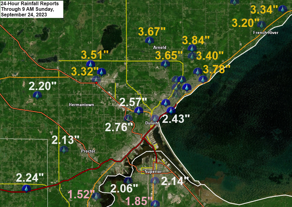
24-Hour Rainfall Reports through 9 AM Sunday, September 24, 2023
Soure: National Weather Service Duluth, Minnesota
3.6 NNW Two Harbors, MN: 4.17″
5 NNW Knife River, MN: 4.15″
4.6 NE Duluth, MN: 4.05″
0.7 NNE NNE Duluth, MN: 4.00″
Duluth Airport: 3.93″
4 NNW French River, MN: 3.65″
Hermantown, MN: 3.51″
0.5 NW Palmers, MN: 3.34″
Duluth Sky Harbor Airport: 2.71″
Poplar, WI: 2.46″
Esko, MN: 2.43″
Aurora, MN: 2.26″
2.1 ESE Cloquet, MN: 2.17″
2.0 WNW Superior, WI: 2.14″
Superior Airport: 2.10″
5.7 E Askov, MN: 1.95″
2.3 NNE Embarrass, MN: 1.80″
Saginaw, MN: 1.80″
Two Harbors, MN: 1.78″
Eveleth, MN: 1.71″
0.4 W Silver Bay, MN: 1.64″
Moose Lake, MN: 1.60″
6.0 N Cook, MN: 1.55″
2.3 S Wrenshall, MN: 1.53″
Hinckley, MN: 1.51″
6 SW Finlayson, MN: 1.49″
6.1 SW Pine City, MN: 1.45″
Silver Bay, MN: 1.45″
Minong, WI: 1.45″
9.2 NNE Wright, MN: 1.42″
0.7 N Aitkin, MN: 1.42″
Spooner, WI: 1.42″
Cook, MN: 1.36″
Orr, MN: 1.31″
6.1 N Grand Rapids, MN: 1.30″
McGregor, MN: 1.25″
Hayward, WI: 1.09″
Chisholm-Hibbing Airport: 1.05″
Webb Lake, WI: 0.99″
Bigfork, MN: 0.96″
Winter, WI: 0.79″
Siren, WI: 0.78″
The Bay of Grand Marais, MN: 0.56″
International Falls, MN: 0.48″
Cass Lake, MN: 0.32″
Walker, MN: 0.31″
Mid and upper-level low continues to spin over west central Minnesota late this morning, and this low won’t be pulling away from the Northland until Tuesday.
Goes-16 water vapor loop from Sunday, September 24, 2023 (loop time ends 11:21 AM CT)

More rain is likely across parts of the Northland today, tonight and Monday with occasional breaks in the rain.
NAM 3km model radar forecast through 7 PM Monday.

Additional rainfall amounts through Monday night ranging from around 0.25 inches to over 2 inches are possible in northeast Minnesota and northwest Wisconsin, with the highest totals near Lake Superior (North Shore) and from east central Minnesota into northwest Wisconsin.

Thanks for reading!
Tim
Leave a Reply