6:00 PM Saturday, October 21, 2023
One system moves away from the Northland tonight which will bring an end to the rain showers that we saw today.
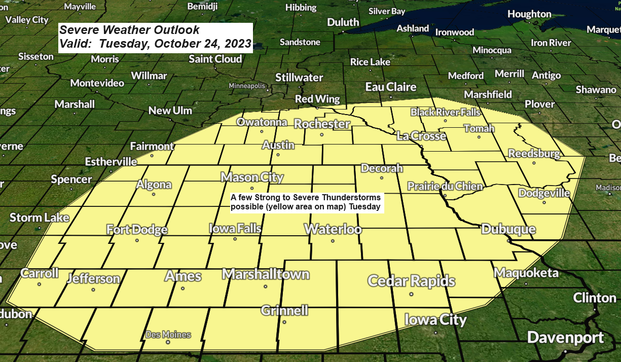
Looks mainly dry in our area during the day on Sunday, but some more rain showers are likely Sunday night, and these showers could then continue at times in parts of the Northland Monday and Tuesday as a cold front approaches from the northwest while low pressure moves northeast out of the Central Plains. Note — There is even a chance that we could see a few isolated thunderstorms late Monday night into Tuesday mainly over northwest Wisconsin as elevated CAPE increases, and this combined with steep mid-level lapse rates could help generate some late season thunderstorms in parts of the Northland, but severe weather is not expected in our area on Tuesday, however, there is a risk for a few strong to severe thunderstorms in parts of southern Minnesota, northern/central Iowa, and southwest Wisconsin Tuesday.
There are additional chances for precipitation late next week and even into next weekend, but by that time the computer models continue to be in very poor agreement regarding how the pattern sets up.
Rainfall Reports from Friday night-Saturday, October 20-21, 2023
Source: MesoWest
Note — Totals below are through 5:32 PM on October 21st.
Seagull Lake, MN: 1.01″
The Bay of Grand Marais, MN: 0.97″
Winton, MN: 0.93″
Schroeder, MN: 0.51″
Isabella, MN: 0.51″
Glidden, WI: 0.41″
Washburn, WI: 0.22″
Ashland, WI: 0.21″
Ely, MN: 0.21″
French River, MN: 0.20″
Saginaw, MN: 0.19″
Two Harbors, MN: 0.16″
Poplar, WI: 0.14″
Duluth Sky Harbor Airport: 0.12″
Duluth Airport: 0.10″
Littlefork, MN: 0.06″
Esko, MN: 0.06″
Chisholm-Hibbing Airport: 0.05″
Hayward, WI: 0.05″
Hill City, MN: 0.04″
Minong, WI: 0.03″
Bigfork, MN: 0.02″
Solon Springs, WI: 0.02″
Siren, WI: 0.01″
NAM 3km model radar forecast valid from 7 PM Sunday to 1 PM Monday.

Total precipitation forecast through 7 AM Wednesday.

Next week will start with warmer than average temperatures in the Northland, but colder air still looks like it’ll move east out of western Canada and the Northern Rockies and into our area but probably not until late next week or possibly not until next weekend.
Note — Highs only in the 30s to around 40 degrees continue to be a real possibility in the Northland with even a chance that highs don’t even reach 30 degrees on a few days between late next week and Halloween.


There continues to be a chance that will see a little snow in parts of the Northland sometime late next week or next weekend, but at the moment it doesn’t look like it would be a huge snow event for our area.

Scattered showers have been moving south/southeast through parts of northeast Minnesota and northwest Wisconsin today as an upper-level trough moves southeast across the Great Lakes. Note — These showers will come to an end by late this evening.
Radar loop ending 4:54 PM CT, Saturday, October 20, 2023.

Goes-16 water vapor loop from Saturday, October 20, 2023 (loop time ends 4:30 PM CT)

Thanks for reading!
Tim
Leave a Reply