6:03 PM Thursday, February 15, 2024
- Friday will mark the end of our streak of above average temperatures in Duluth as will finally get a day with a below average temperature which would be the first since January 20th, or 26 days ago.
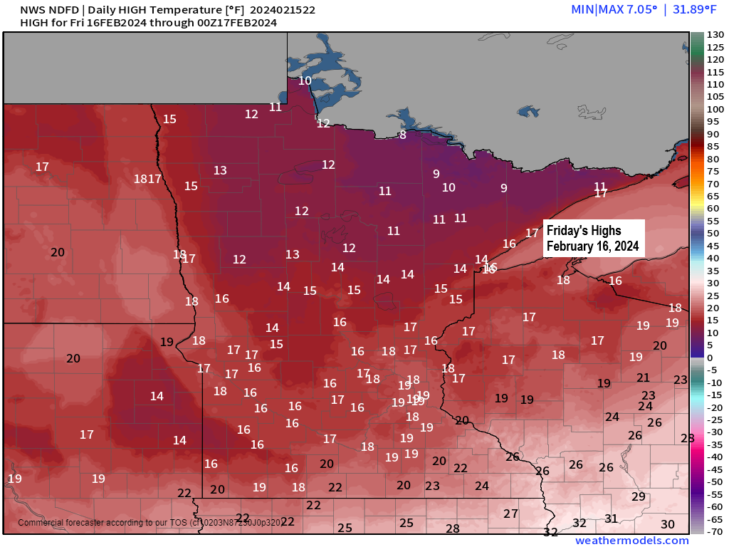
- Highs on Friday will range from around 10 to 15 degrees in the Northland with lows tonight and Friday night ranging from around 8 below to 10 above zero.
- No subzero temperatures in Duluth so far this month and it doesn’t look like will be recording any subzero temps for possibly the rest of this month. More info. below.
Since 1875, there’s only been 4 years on record where Duluth didn’t have any subzero low temperatures in February. Those years include 1998, 1882, 1878, and 1877. Will we add 2024 to this list? Time will tell.
Note: Other notable mentions include February 1915 which had 1 subzero low temperature in Duluth, while more recently in February 2012 Duluth had 2 nights with a subzero low temperature.
Something we haven’t seen around here since about mid-January and that would be some arctic air.
A colder airmass has moved into the Northland today with 850mb temperatures of around -15C but even colder air is sitting to our north today with -20 to -25C 850mb temperatures, and that airmass will move over the Northland on Friday.

Seeing temperatures in the single digits and teens below zero this afternoon across parts of Manitoba and Ontario and this is the source region of where our colder temperatures will be coming from through Friday, although temperatures in our area won’t be as cold as they are a little farther north.

Only 0.6 inches of snow so far this month in Duluth. The least snowy February on record for Duluth is 2.1 inches set in 1896.
If you believe the long-range computer models, then it doesn’t look like Duluth will break the record for least amount of snow in February as both the EPS and GEFS models show Duluth getting enough snow to put us over the 2.1″ mark by the end of this month. Note: An additional 1.6 inches of snow is needed by the end of this month to make sure we don’t break the record from 1896.
Euro ensemble model forecast.

GEFS model forecast.

Around 1 to nearly 5 inches of snow fell Wednesday evening into early Thursday morning over parts of eastern Minnesota into southern portions of northwest Wisconsin. See below.
Snowfall reports from the Northland from February 14-15, 2024
Source: National Weather Service Duluth, Minnesota
3 E Sarona, WI: 4.8″
Winter, WI: 4.0″
4 NNE Sarona, WI: 3.7″
1 S Ojibwa, WI: 3.5″
2 WNW Stone Lake, WI: 3.0″
4 NNW New Post, WI: 2.3″
Trego, WI: 2.0″
1 SW Hayward, WI: 2.0″
6 NE Hertel, WI: 1.8″
1 SW Grantsburg, WI: 1.8″
Pine City, MN: 1.8″
3 WNW Clam Lake, WI: 1.5″
Gile, WI: 1.3″
4 SSE Webster, WI: 1.3″
3 W Stanberry, WI: 1.2″
A swath of about 4 to 6″+ of snow Wednesday from parts of south-central Minnesota into western Wisconsin. Southern portions of the Northland were on the northern edge of this quick hitting snowy system.

Thanks for reading!
Tim
Leave a Reply