6:25 PM Wednesday, February 14, 2024
Snow will continue to fall and accumulate tonight across central and southern Minnesota into much of Wisconsin. Will see this snow taper off from west to east later tonight, ending first in Minnesota.
Southern parts of the Northland mainly from between Hinckley and Pine City east to Minong, Hayward, Glidden and Mercer and points south could see around 1 to 2 inches of snow tonight with higher snowfall amounts expected a little farther south.
Tonight’s snowy system will stay south of Duluth with no snow expected in the Twin Ports tonight.
18z NAM 3km model simulated radar forecast through 6 AM Thursday.

NWS Blend of models snowfall forecast through 6 AM Thursday.

Winter weather alerts remain in effect tonight into early Thursday morning for parts of central and southern Minnesota into much of western, central and eastern Wisconsin.

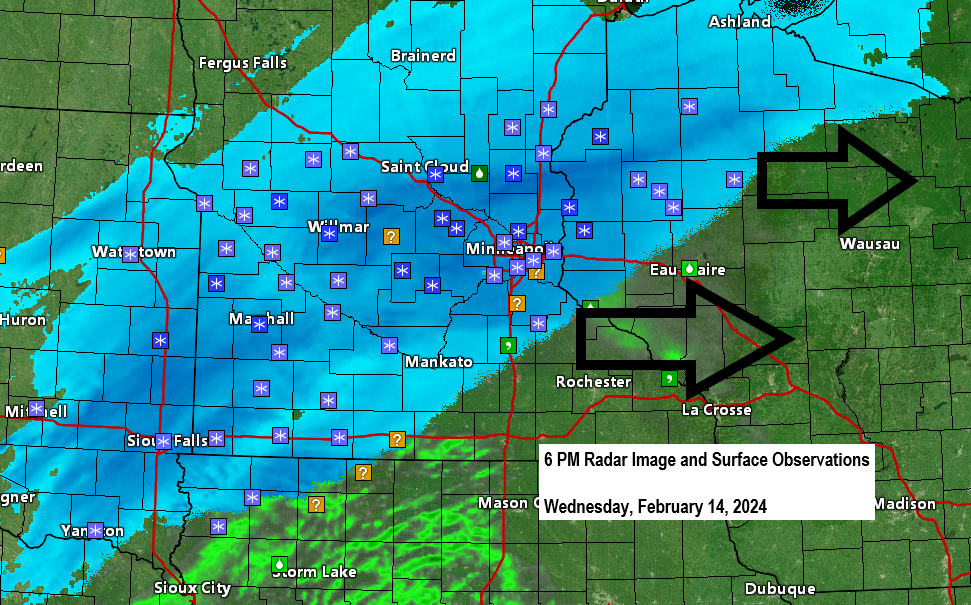
Strong lift (yellow and orange colors on the map below) has led to some heavier bursts of snow with today’s system across parts of South Dakota and Minnesota and this area of stronger lift and heavy snow potential will shift farther east into parts of Wisconsin tonight.

Today’s system has a nice temperature gradient to work with as we’re seeing temperatures in the 50s in parts of northern Iowa with 20s in much of North Dakota.

Here are just a few snowfall reports from today.
8 inches of snow has fallen in the Huron, South Dakota area today.

Over 3 weeks in a row with above average temperatures in Duluth. Note: This streak should come to an end on Friday.

We do have some colder weather coming the next few days with the coldest air on Friday when will have 850mb temperatures as cold as -20C in much of the Northland.

Highs on Friday are forecast to only be in the lower teens to around 20 in the Northland. By far the coldest we’ve been in about a month!
Lows Thursday night and Friday night are forecast to be in single digits below zero to around 10 above zero in the Northland but it doesn’t look like will see subzero temperatures occur in Duluth late this week. Note: Our last subzero temperature in Duluth was on January 20th (low of -11).
This cold airmass won’t stick around long, however, as will see highs get back into the 30s again this weekend into early next week, so more or less about a 1- or 2-day cold shot.

Thanks for reading!
Tim
Leave a Reply