5:52 PM Tuesday, February 13, 2024
A few snow showers and flurries will move through the Northland tonight into Wednesday morning with snowfall accumulations of a trace to an inch at most.
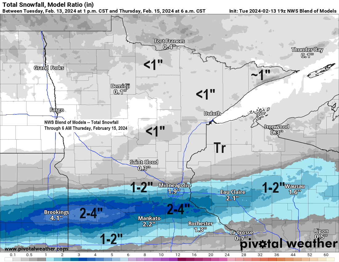
A quick hitting snowy system will impact portions of southern Minnesota Wednesday afternoon into Wednesday night, but this system will likely miss most of the Northland with the exception to this in far southern portions of northwest Wisconsin where we could get a little snow Wednesday night with around an inch of accumulation possible along and south of a line from around Siren to Hayward.
Snow will begin in southwest Minnesota late Wednesday morning/early afternoon, and then will see this snow move farther east across parts of southern Minnesota late Wednesday afternoon into Wednesday night. Note: Precipitation could begin as rain in southern Minnesota before changing over to snow.
Plan on slippery road conditions due to this snow in parts of southern Minnesota Wednesday afternoon into early Thursday morning.

There will be some pretty strong lift with this system in southern Minnesota Wednesday so we could see a few bands of heavier snowfall develop with snowfall rates up to 1″/hour possible late Wednesday afternoon/night.
NAM model 700mb forecast valid 6 AM Wednesday to 6 AM Thursday.

Snow showers and flurries tonight into Wednesday morning across northern Minnesota and northern Wisconsin, and then it’ll be southern Minnesota’s turn to get some snow Wednesday afternoon/night, and this snow will also spread into western-central Wisconsin Wednesday night.
HRRR model simulated radar forecast through 6 AM Thursday.

Least snowy Februarys on record in Duluth.
Only 0.6 inches of snow so far this month in Duluth, and long-range model trends don’t look very snowy, so it’s possible that February 2024 will end up in the top 5 for least amount of snow in Duluth, and possibly even in the number 1 spot. Time will tell.
- 2.1 inches set in 1896
- 2.3 inches set in 1988
- 2.4 inches set in 1888
- 2.7 inches set in 1968, 1967 and 1894
- 3.0 inches set in 1973, 1969, 1928 and 1918
Not a whole lot of snow so far this month in Minnesota, in fact much of southern Minnesota has only seen around a trace of snow so far this month, but that will likely change a bit over the next 24 hours or so.

Percent of normal snowfall for February 2024 (thru the 13th)
International Falls: 42% of normal
Duluth: 9% of normal
St. Cloud: 2% of normal

A brief shot of colder temperatures late this week (Friday-Saturday), but after that it continues to look like will see a return of warmer than average temperatures in the Northland for next week, but much colder temperatures won’t be far away as they cover much of central/eastern Canada, and if the upper-level pattern amplifies enough then we could tap into some of this cold air at times next week, but at the moment those chances look pretty low.
Note: Next week’s temperatures in the Northland look to be in the 30s for highs with a chance for some 40s on a few days especially later next week.

Thanks for reading!
Tim
Leave a Reply