6:50 PM Monday, February 26, 2024
We’ve got some major changes in the weather coming Tuesday into Wednesday.
Lots to cover in today’s blog. I haven’t been able to say that in what seems like months.
- The entire Northland will see temperatures some -40 to -60 degrees colder from today’s highs to the temperatures that are forecast Wednesday morning.
- Heavy snow accumulations (6″+) targeting far northern Minnesota Tuesday.
- Some snow showers and flurries with minor accumulations expected for east central Minnesota, northwest Wisconsin including Duluth late Tuesday afternoon/night.
- Another strong system could affect the Northland early next week (~March 3-5)
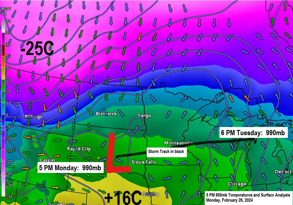
Talk about some crazy weather changes at International Falls today. 1.5 inches of snow fell at I’Falls earlier today with a low temperature of 10 degrees, this was all followed by record warmth this afternoon, and now I’Falls is under a winter storm warning for heavy snow potential on Tuesday. Wild!
*Chances are increasing that February 2024 will go into the record books as the least snowy February on record in Duluth. Snowfall total so far this month 1.4 inches. The least snowy February on record is 2.1 inches set in 1896.
*Today’s high of 54 degrees in Duluth marked the 3rd time this month with a temperature of at least 50 degrees, and this ties the record from February 2017 for the greatest number of days with a temperature of at least 50 degrees. Weather records for Duluth date back to 1875.
I did make some changes to my snowfall forecast today for Tuesday’s system.
Will likely see sharp snowfall gradients set up across northern Minnesota Tuesday.
Note: Uncertainty remains on the southern extent of the highest snow totals in northern Minnesota Tuesday.
Snowfall forecasts for Tuesday
- International Falls: 6 to 9 inches
- Bigfork: Around 6 inches
- Cook: 3 to 6 inches
- Grand Rapids: Trace to 2 inches
- Hibbing: Trace to 2 inches
- Ely: Trace to 2 inches
- Duluth: Trace to 1 inch
Much of east central Minnesota including Duluth and the North Shore could see a trace to 1 inch of snow, and this is also the case for much of northwest Wisconsin, but there could be a corridor of slightly higher snow totals of 1 to 3 inches in southern/eastern portions of northwest Wisconsin Tuesday night.

Heavy snowfall rates of around 1″/hour are expected Tuesday in far northern Minnesota (black outlined area on map) The potential for heavy snow is greatest from around 6 AM to Noon Tuesday.

Snow develops in far northern Minnesota late tonight/early Tuesday morning and this snow will likely persist through the day Tuesday before tapering off Tuesday evening.
Snow showers and flurries in east central Minnesota, Twin Ports and northwest Wisconsin mainly from mid or late afternoon Tuesday through early Wednesday morning.
European model simulated radar forecast valid from Midnight tonight to 6 AM Wednesday.
Snow in blue colors.

Current NWS winter weather headlines.

Extremely different weather conditions are likely across the Northland Tuesday.
Far northern Minnesota will be getting snow, and it will likely be heavy at times with some blowing snow likely as well. Temperatures in far northern Minnesota will only be around 10 degrees on Tuesday.
Meanwhile some parts of northwest Wisconsin could see temperatures in the 50s Tuesday before dropping later in the day.
European model forecast for Tuesday.

And here’s the temperature forecast valid for early Tuesday afternoon. Wow!

Look at all the different weather alerts that are in effect.
Black outlined area is where we may see near blizzard conditions develop for a time Tuesday (parts of eastern North Dakota into parts of northwest Minnesota).

Today’s highs in the Northland and their departure from normal for February 26th
*=Daily record high temperature tied
Ashland, WI: 57 (+26 degrees above normal)
Duluth, MN: 54 (+25 degrees above normal)
International Falls, MN: *53 (+26 degrees above normal)
Brainerd, MN: 53 (+22 degrees above normal)
Hibbing, MN: *52 (+25 degrees above normal)
Note: Today’s record high of 53 at International Falls was set in 1958, and Hibbing’s record high of 52 today was also set in 1958.
Note: The first 70s of the year in Minnesota today (February 26th) with a few locations in far southern Minnesota reporting temperatures of 70 or warmer this afternoon.
- Austin: 72
- Albert Lea: 70
- Preston: 70
- Winona: 70
Temperatures in northeast Minnesota and northwest Wisconsin were in the 50s today with cooler temperatures closer to Lake Superior.

Widespread subzero temperatures are likely Wednesday morning across north central into northeast Minnesota with single digit above zero temperatures expected in far eastern Minnesota and northwest Wisconsin.
Note: Duluth still hasn’t recorded a subzero temperature this month. The last time it was below zero in Duluth was on January 20th with a low of -11 degrees.

A big-time temperature contrast today ranging from the 80s and 90s in parts of the southern Plains to the single digits below zero in much of western and central Canada.

Look at all the locations tying or breaking high temperature records today (orange and red colors) while the magenta colors represent locations which are tying or breaking monthly high temperature records.

Temperatures across the Midwest on this 26th day of February were running some +30 to +45 degrees above normal for this time of the year, incredible!

***Severe Thunderstorm Potential Tuesday***
Tuesday’s storm will also have a potential to produce some early season severe weather over parts of Illinois, Missouri, Indiana, Ohio and Michigan, and possibly as far north as southern portions of Wisconsin.
The highest potential for severe thunderstorms Tuesday is in the yellow area on the map below.

Severe thunderstorms that do develop Tuesday will be capable of producing large hail of 1 to 2 inches in diameter, damaging wind gusts to 60 mph along with a couple of tornadoes with the tornado threat highest in the brown area on the map below.

Here’s the NAM 3km model simulated radar forecast valid 3 PM Tuesday to 6 AM Wednesday.

The NAM 3km model shows some high values of updraft helicity Tuesday-Tuesday night especially across north central Illinois (yellow, orange and red colors). This doesn’t mean there will be tornadoes, but it does mean there is potential for rotating updrafts which could lead to large hail along with a tornado threat should storms develop.

And I’ll leave you with this. There’s a potential that will see another large system impact the upper Midwest sometime late this weekend-early next week as a deep trough pushes east-northeast out of the western U.S. This will be a system to watch as it could produce severe weather, snow, rain and possibly even some freezing rain (icing) Stay tuned.

Thanks for reading!
Tim
Leave a Reply