6:31 PM Sunday, February 25, 2024
Some quick changes in the weather on the way over the next few days with a variety of weather including spring like warmth and possible record highs Monday followed by some snow and a shot of arctic air late Tuesday-Wednesday with subzero temperatures possible in parts of the Northland Tuesday night/Wednesday morning.
Temperatures rebound late this week into next weekend with more 40s and 50s looking likely in much of the Northland with 60s even possible in some parts of the Northland next weekend while temperatures in the 70s could push north into parts of western, central and southern Minnesota next weekend.
But first, we could see a quick band of snow move east across northern Minnesota Monday morning with snowfall amounts of a trace to an inch possible. It looks like this band of snow will stay north of Duluth Monday morning.
18z NAM 3km model simulated radar forecast valid from 4 AM Monday to 12 PM Monday.

NWS Blend of Models snowfall forecast through Noon Monday.

Record or near record warmth possible in the Northland Monday.
Here are the record highs for February 26th.
Ashland, WI: 58 set in 1894
Duluth, MN: 58 set in 1895
Brainerd, MN: 55 set in 1976
International Falls, MN: 53 set in 1958
Hibbing, MN: 52 set in 1958

System for Tuesday
A strong upper-level trough will move east across the northern Plains and upper Midwest on Tuesday and will pass over the Great Lakes Wednesday. This trough looks to move through fairly quickly, and it doesn’t look like will be seeing much phasing occur between a northern wave and a southern wave. What this all means is that the greatest chance for getting several inches of snow will be over parts of northern Minnesota with a lesser chance in Duluth, east central Minnesota and in much of northwest Wisconsin.
Timing of this snow looks to be during the day Tuesday across northern Minnesota with some snow possible farther south/east including in Duluth, eastern Minnesota and northwest Wisconsin from Tuesday afternoon into early Wednesday morning.
12z European computer model simulated radar forecast valid 1 AM Tuesday to 6 AM Wednesday.

Here’s my preliminary snowfall forecast for the Tuesday-early Wednesday system. Note: Changes in snowfall amounts and gradients are possible over the next 24 hours.

Here’s a look at the upper-level pattern and also the temperatures from late Sunday afternoon.
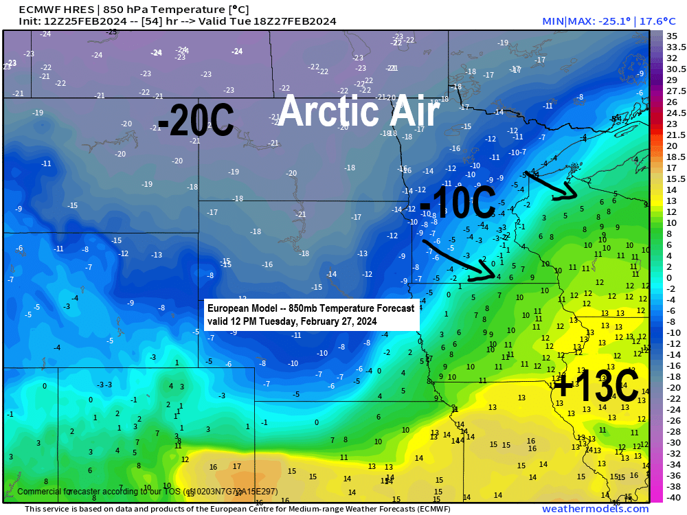
Seeing summer like warmth in parts of Texas today with temperatures in the 80s with even a few 90s in southwest Texas, meanwhile a pool of arctic air continues over central/northern Canada with temperatures in the teens and 20s below zero today. Note: The Northland will see another brief shot of arctic air move through Tuesday night into Wednesday with subzero temperatures looking likely in much of the area Wednesday morning.

Goes-16 water vapor loop from Sunday, February 25, 2024 (loop time ends 6 PM CT)

Thanks for reading!
Tim
Leave a Reply