6:22 PM Wednesday, February 28, 2024
Southerly winds and a warm air advection pattern will develop in the Northland over the next few days as will see 850mb temperatures increase from around -20 to -25C this afternoon to around +3 to +9C by Friday.
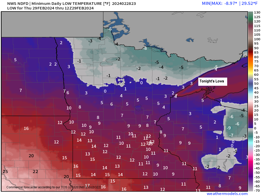
But before we see these milder temperatures return, another very cold night is ahead of us as will see lows ranging from around 10 below to 5 above zero in the Northland tonight.
Highs Thursday will range from the 20s along the North Shore of Lake Superior and in far northern Minnesota with milder 30s and 40s elsewhere in the Northland.
Southwest winds increase Friday with temperatures getting into the low to mid 50s in much of the Northland.
Cooler temperatures return this weekend especially near Lake Superior as the pattern will be favorable for northeast winds off the lake as we see an area of low-pressure approach from the western High Plains while a warm front sets up over central Minnesota. Those northeast winds near Lake Superior will likely keep high temps in the mid 30s to around 40 Saturday and Sunday, but farther inland from Lake Superior highs in the 40s and 50s are likely with a few 60s possible on Sunday.
The system approaching from the western High Plains doesn’t look like it’ll be a major system for the Northland with only scattered precipitation expected mainly from Sunday afternoon into Monday.
- February 2024 will likely rank as the least snowy February on record at Duluth, Minnesota with just 1.6 inches of snow this month. The least snowy February on record at Duluth occurred in 1896 with 2.1 inches of snow. Weather records for Duluth go back to 1875.
Snowfall this month has been below normal across much of the Northland, especially from around Brainerd and Walker east to Grand Rapids, Duluth and the North Shore of Lake Superior.
International Falls: 8.9 inches (-3.7 inches below normal)
Duluth: 1.6 inches (-13.5 inches below normal)

Percent of normal snowfall this month ranges from around 70% of normal at International Falls to only around 11% of normal snowfall at Duluth.

Our next shot for getting some precipitation in the Northland comes Sunday afternoon into Monday as will see another trough lift northeast across the northern Plains and upper Midwest. Note: Model guidance has sped this system up quite a bit compared to how things looked a few days ago, and this system doesn’t look quite as strong as it did a few days ago. What this all means is that this likely won’t be a major rain or snow event in our area, but some scattered rains are likely Sunday into Monday with some snow also possible in some parts of the Northland, but minimal snow accumulations are expected the way things look now.
EPS model 500mb forecast valid March 3-4, 2024.
Troughs/unsettled weather in blue and green colors.
Generally quiet weather and ridging in red and white colors.

For late February this is pretty cold, especially given the fact that we saw a lot of sunshine in the Northland today.
Seeing temperatures only in the single digits and teens in our area this afternoon which is about -10 to -20 degrees below normal for this time of year.

Here’s a larger view of temperatures from late Wednesday afternoon.

Temperatures this afternoon from parts of the southern Plains to Great Lakes were running some -30 to -50 degrees colder compared to the temperatures from Tuesday afternoon.

Severe thunderstorms impacted parts of the Midwest and Ohio Valley Tuesday evening into early Wednesday morning with a total of 121 filtered severe weather reports.
Tornado reports: 12
Wind reports: 62
Hail reports: 47

Thanks for reading!
Tim
Leave a Reply