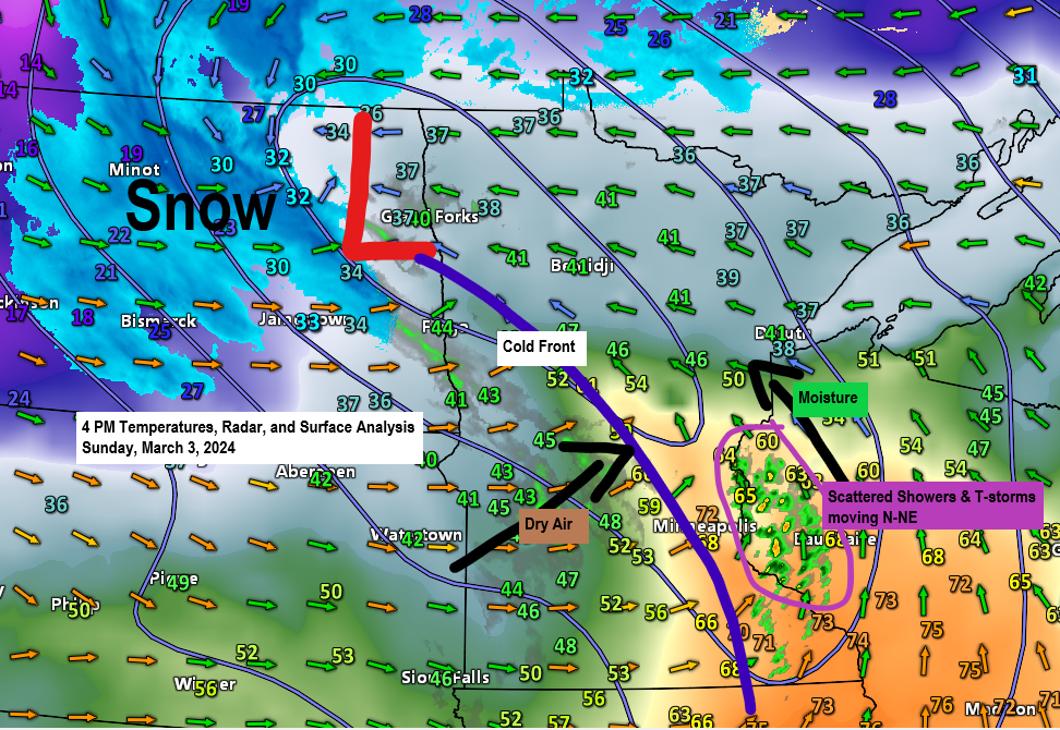
4:27 PM Sunday, March 3, 2024
Scattered showers and a few thunderstorms will move through parts of the Northland this evening dropping anywhere from a trace to around 0.25 inches of rain in some locations, but not everyone will get rain tonight.
Windy weather will continue through Monday morning as south/east winds become southwesterly tonight. Wind gusts to 45 mph are likely in the Northland tonight into early Monday morning.
Highs on Monday will range from the lower 30s in far northern Minnesota to the 40s in east central Minnesota, Twin Ports, North Shore and northwest Wisconsin.
A few rain or snow showers are possible Monday mainly in parts of northwest Wisconsin but little to no snow accumulation is expected.
Chances for some more rain or snow showers mid to late week but again no major snow accumulation is expected the way it looks now.
Rainfall forecast through 6 AM Monday.

NAM 3km model simulated radar forecast through Midnight tonight.

A few thunderstorms are likely early this evening mainly in parts of northwest Wisconsin into northeast Minnesota. Brief downpours are possible with these storms along with some lightning, but no severe weather is expected.

Windy weather will continue in the Northland tonight as south/east winds shift to the southwest with the passage of a cold front. Wind gusts from 25 to around 45 mph are expected tonight, and breezy conditions will likely persist into Monday morning although probably not as windy as it will be tonight.
HRRR model wind gust forecast through 12 PM Monday.

This is one of the crazier smoke plumes I’ve seen being picked up on radar imagery.
A wildfire located north of Waseca, Minnesota this afternoon has produced quite a smoke plume stretching from around Faribault north to Minneapolis. Strong southerly winds are pulling this smoke plume to the north and northeast.
There’s been reports of ash falling from the sky in the Savage, MN area this afternoon.

Crazy warm for early March.
Widespread 70s this afternoon over about the southeast half Minnesota into southcentral Wisconsin with a few 80s in eastern Iowa including 80 degrees at Waterloo at 3 PM today.
Note: Minneapolis recorded its earliest 70 degree day on record with a temperature of 71 at 3 PM today, March 3rd. The previous earliest 70 degree day was March 5th, 2000.
Meanwhile in the colder air there’s been quite a bit of snow today in parts of North Dakota with a report of 9 inches of snow northwest of Minot, and other reports of about 2 to 4 inches of snow south of Minot.

Widespread record warmth today anywhere you see an orange or red icon on the map below.

A strong mid and upper-level trough will continue to lift north/east through the upper Midwest tonight.

A strong warm advection pattern will continue into early this evening in the Northland, but cold air advection will quickly approach from the southwest during the night.
850mb temperatures of around +4 to +10C at 6 PM this evening is expected to fall to around -12 to +1C by 6 AM Monday (lowest 850mb temps in northern Minnesota).

Winds aloft or in this case at around 18,000 feet will be cranking tonight into early Monday morning as 500mb winds increase to around 100 knots to as strong as 135 knots across northern Minnesota into southern Ontario Canada.

Goes-16 visible satellite loop ending 4:06 PM Sunday.
Clouds in white on the loop below.

Quite a system lifting north through the northern Plains and upper Midwest today.
Goes-16 water vapor loop ending 3:50 PM Sunday.

Thanks for reading!
Tim
Leave a Reply