5:21 PM Monday, March 11, 2024
Record highs set or tied in the Northland today, Monday, March 11th, 2024.
- Brainerd, MN: New record 65 (old record 60 set in 2012 and 2016)
- Ashland, WI: 65* Ties the record high for March 11th which was set in 2012
- Duluth, MN: New record 63 (old record 60 set in 1902)
- International Falls, MN: 61* Ties the record high for March 11th which was set in 2012 and 2016.
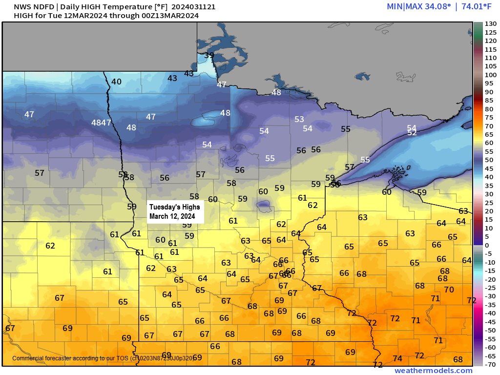
More mild temperatures on the way Tuesday with highs in the 50s in far northern Minnesota and in the low to mid 60s in eastern Minnesota and northwest Wisconsin.
Note: Record warmth is possible again on Tuesday, here are the record highs for March 12th
Brainerd: 64 set in 2016
Ashland: 64 set in 2016
Hibbing: 62 set in 2016
Duluth: 60 set in 2016
International Falls: 60 set in 2016
Temperatures stay above normal mid to late week although not as warm as what we’re seeing right now.
Highs Wednesday are forecast to range from the mid 40s to upper 50s from north to south across the Northland. Highs mainly in the 40s are then forecast for Thursday through Saturday.
Duluth hit 60 degrees for the first time this year today with a high of 63.
Today’s 60 is the 3rd earliest 60 on record in Duluth — See below.
- March 6th (1987)
- March 7th (2000)
- March 11th (2024 and 1902)
Going back to 1875 when weather records began in Duluth, there’s only 3 years (now 4) where the first 60 degree temperature occurred on or before March 11th.
Check out these temperatures across the region on this 11th day of March 2024.
Seeing widespread low to mid 70s this afternoon in southwest Minnesota including 76 at Canby.
60s were widespread across northeast Minnesota and northwest Wisconsin this afternoon.

Temperatures across the region this afternoon were running some +25 to nearly +40 degrees above normal for March 11th.

Orange and red colors on the map below represent locations tying or breaking their daily record high temperature as of 3 PM Monday, March 11th, 2024.

Looking ahead shows that the pattern may turn a little more active at times and cooler as well as we get into mid to late month.
Shown below is the GEFS model height anomaly forecast for Duluth through March 27th.
Orange colors on the chart below represent higher 500mb heights and upper-level ridging which usually leads to tranquil weather.
Blue, green and purple colors on the chart below represent lower 500mb heights and potentially cooler/active weather at times.

LATE WEEK PRECIPITATION CHANCES
An area of low pressure is forecast to move east-northeast out of the central Plains mid to late week.
It looks like this system will pass well south of the Northland with little to no precipitation expected in our area Thursday into Friday, but there are a few computer models that show the low taking a more northerly track, and if that were to occur, then chances for getting some rain or snow would increase in parts of eastern Minnesota and northern Wisconsin in the Thursday-Friday time frame.
There are several GEFS members of the 20 which do show some precipitation reaching into southern portions of the Northland late this week.
Shown below is the 20-member GEFS model precipitation type forecast for 7 PM Thursday with rain in green and snow in blue.

Thanks for reading!
Tim
Leave a Reply