6:35 PM Wednesday, March 27, 2024
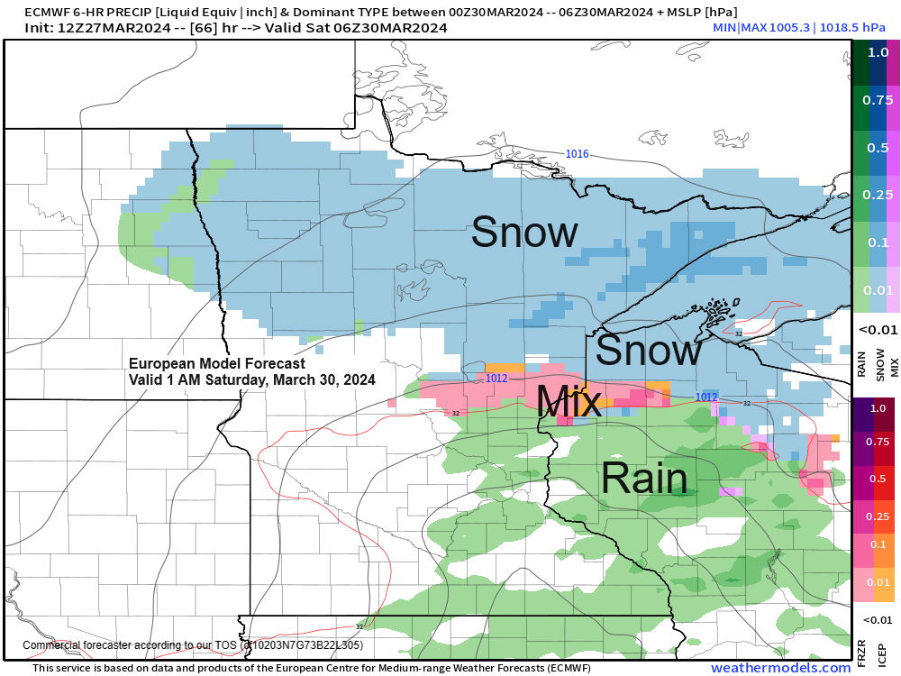
A brief break in this active weather pattern is on the way for Thursday and a part of Friday, but a quick hitting system could impact the Northland late Friday afternoon into Saturday morning bringing another round of snow and mixed precipitation to the area.
These spring systems can be pretty potent and sure enough there’s some signals showing up in the computer models for a period of enhanced lift passing through the Northland Friday night which could lead to a few hours of moderate snow or mixed precipitation in parts of the area. A few computer models even show some weak instability along with steep mid-level lapse rates >7.0 c/km which could lead to some convective like precipitation Friday night.
The overall quick movement of this system should keep snowfall totals from getting out of hand Friday night-Saturday morning but there is a chance for some parts of the Northland to pick up another 1 to 3 inches of snow during the aforementioned time period, with northern Minnesota having the greatest chance at those kind of snow totals the way it looks now.
Here’s the 700mb forecast from the NAM model valid 7 AM Friday to 7 AM Saturday.
Yellow, orange and red colors on the loop below represents stronger lift and a potential for heavier precipitation.

European computer model simulated radar forecast valid 1 PM Friday to 1 PM Saturday.
Snow (blue)
Mix (pink)
Rain (green)

Still dealing with our current storm today as the 500mb low passes through the area which led to more snow at times in the Northland today, and conditions have also been favorable for snow squall development over parts of the area today and those snow squalls have been producing brief but heavy bursts of snow today.

NAM 3km model simulated radar forecast through 7 AM Thursday.
Snow showers and squalls will gradually diminish in the Northland tonight but before that happens, we could see another 1 to 2 inches of snow in some parts of the area.

It’s been a cold late March Day across the area with temperatures only in the upper teens and 20s today.

Will finally get a day without any snow in the Northland on Thursday with quite a bit of sunshine expected for a change, enjoy.

Temperatures will still be on the cool side however, with highs Thursday mostly in the low to mid 30s in northeast Minnesota and northwest Wisconsin. Normal highs in our area in late March are mainly in the lower 40s.

LONG RANGE FORECAST
Seeing signals in the computer models for a potentially active pattern in the April 4-9 time frame as a trough sets up over the western U.S. with upper-level ridging farther east.
Storm tracks and where the warm air/cold air sets up this far in advance is very uncertain, but the potential is there for some more active weather which could impact the upper Midwest and Northland in the April 4-9 time frame.

Currently it looks like the Northland will sit between where the well below average and well above average temperatures will be from April 4-9 according to the Euro Ensemble (EPS) model.

Thanks for reading!
Tim
Leave a Reply