5:59 PM Thursday, May 9, 2024
- Another cold night is expected, with the possibility of frost and freezing conditions primarily in northwest Wisconsin, as well as in northeast and far eastern Minnesota. Lows in these areas are expected to be in the upper 20s to middle 30s tonight.
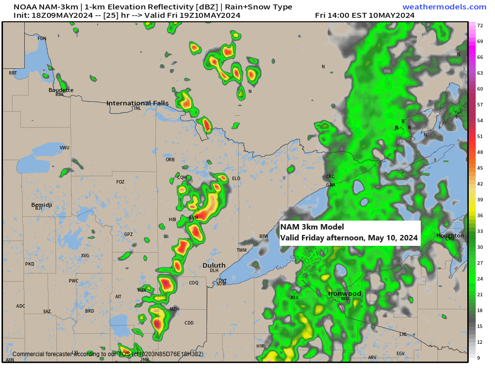
- Expect some showers and occasional thunderstorms on Friday, accompanied by isolated short-lived heavy downpours.
- The forecast for Saturday and Sunday indicates predominantly dry conditions, though there is a chance for some isolated showers or thunderstorms on Sunday.
- This weekend, expect milder temperatures near Lake Superior due to a prevailing offshore wind direction. Highs are anticipated to be in the 60s on Saturday and could reach the low to mid-70s by Sunday.
The convergence of a moving cold front and a zone of colder upper-air temperatures, reaching as low as approximately -25°C, along with warmer surface temperatures, will contribute to atmospheric instability on Friday. This instability is expected to result in isolated to scattered showers and thunderstorms. The likelihood of thunderstorms will be greatest in the afternoon and early evening when the instability is at its maximum.

While widespread strong or severe thunderstorms are not expected in our area on Friday afternoon, there is still a possibility of a few isolated stronger storms. These could produce winds ranging from 40 to 50 mph and small hail, typically less than half inch in diameter. Note: The risk of stronger storms Friday afternoon is highest in the green area on the map below.

NAM 3km model simulated radar forecast valid 7 AM to 10 PM Friday.

Expected rainfall in our area on Friday ranges from a mere trace to about 0.25 inches, with certain areas possibly receiving more than 0.50 inches due to isolated pockets of heavier rain.

Another night with the potential for frost and freezing conditions is expected throughout northwest Wisconsin and parts of northeast and far eastern Minnesota.
-Freeze Warning (darker blue) from 10 PM this evening to 8 AM Friday with sub-freezing temperatures as low as 30 expected.
-Frost Advisory (lighter blue) from 10 PM this evening to 8 AM Friday with temperatures as low as 33.

Low temperature reports from Thursday morning, May 9, 2024
Source: National Weather Service Duluth, Minnesota
Embarrass, MN: 29
Crane Lake, MN: 30
Hibbing, MN: 32
Ely, MN: 32
Orr, MN: 34
Cook, MN: 34
Brimson, MN: 35
Today, an intensified upper-level pattern persisted, featuring a ridge over southwest Canada and the adjacent Pacific Northwest, along with several troughs extending to the south and east.

Goes-16 water vapor loop ending 5:30 PM CT, Thursday, May 9, 2024.

Take a look at the temperatures in southwest Texas this afternoon; they’re soaring to 108 degrees in Laredo and 107 degrees in Del Rio.
Parts of the northwest and far western US are experiencing notably warm temperatures today.
Parts of western and central Canada are enjoying warmer temperatures, with readings in the 60s and 70s this afternoon.

Thanks for reading!
Tim
Leave a Reply