6:17 PM Monday, June 3, 2024
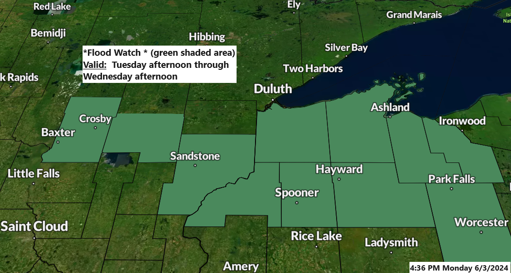
-A Flood Watch will be in effect from Tuesday afternoon until Wednesday afternoon for parts of east central Minnesota and the entirety of northwest Wisconsin. Some cities included in the flood watch are…Hayward, Bayfield, Hurley, Aitkin, Pine City, Grantsburg, Washburn, Spooner, Ashland, Hinckley, and Brainerd.
- Excessive rainfall may lead to flooding.
- Excessive runoff may lead to the flooding of rivers, creeks, streams, and other low-lying and flood-prone areas.
- Creeks and streams might overflow their banks.
Scattered thunderstorms are expected across much of the Northland on Tuesday, with a possibility of some storms intensifying to severe levels, particularly in the afternoon and early evening. The main threat from these severe storms is damaging wind gusts up to 60 mph, although there is also a chance of hail, potentially as large as a quarter (1-inch in diameter).
Note: The highest likelihood of a few severe thunderstorms is indicated by the yellow area on the map below.

Note: The Northland faces a slight and marginal risk of severe thunderstorms on Tuesday. Below is a chart that explains what a slight and marginal risk entails.

Tuesday morning is expected to be mostly dry in the Northland, but conditions are likely to shift by the afternoon. Showers and thunderstorms are anticipated to develop and spread in coverage, moving from west to east. The rainfall is expected to taper off late Tuesday night or early Wednesday morning.
Note: The likelihood of rain in Duluth peaks late Tuesday afternoon into the evening, starting after 3 PM on Tuesday (+/- an hour)
NAM 3km model simulated radar forecast valid 7 AM Tuesday to 7 AM Wednesday.

Note: Ashland, Wisconsin, established a new 24-hour rainfall record today with 1.83 inches. The former record was 1.73 inches, set on June 3, 1944.
Localized areas across the Northland may receive 1 to 2 inches or more of rain on Tuesday afternoon and evening.

In the Northland, average rainfall totals are expected to range from 0.25 inches to an inch on Tuesday afternoon and evening.

The upcoming weather system, currently over the Pacific Northwest and Northern Rockies, will move eastward and is expected to bring additional rain to the Northland on Tuesday and Wednesday.
The upcoming system is expected to be stronger than the one earlier today, as a negatively tilted trough moves northeast across the upper Midwest, inducing a period of intense upward motion in the region.

Today has a muggy feel, with dew points ranging from the mid-50s in Northern Minnesota to the low to mid-60s in Northwest Wisconsin. This humid air mass is expected to remain over the Northland until Tuesday.


Before the rain arrives on Tuesday, afternoon temperatures are expected to rise rapidly into the mid-70s to low 80s across much of the Northland. However, a northeast wind on Tuesday will likely keep temperatures significantly cooler (40s to 50s) within approximately 15-20 miles of Lake Superior. Areas of fog are also expected tonight and Tuesday near Lake Superior, which may affect the Twin Ports area as well.

Thanks for reading!
Tim
Leave a Reply