4:50 PM Tuesday, June 18, 2024
This afternoon, a significant flood threat has emerged across parts of north central and northeast Minnesota, triggered by successive thunderstorms that have unleashed torrential downpours, with rainfall rates reaching 1-2 inches per hour.
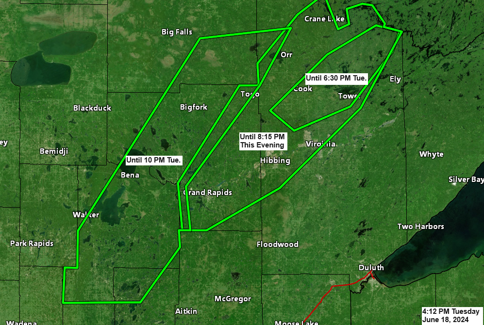
Multiple flash flood warnings, indicated by green outlines on the map, are in effect for areas of northeast Minnesota until later this evening.
Some locations that will experience flash flooding include Walker, Breezy Point, Pequot Lakes, Crosslake, Pine River, Deer River, Emily, Marcell, Bigfork, Remer, Nett Lake, Backus, Longville, Ash Lake, Effie, Bena, Federal Dam, Hibbing, Grand Rapids, Lake Vermilion, Virginia, Chisholm, Mountain Iron, Cohasset, Coleraine, Keewatin, Buhl, Nashwauk, Cook, Tower, Taconite, Orr, Warba, Zemple, Crane Lake and Gheen, and also including the Boundary Waters Canoe Area Wilderness.

More showers and thunderstorms are expected to develop from east central Minnesota into northwest Wisconsin throughout the evening.
Radar loop ends 4:40 PM Tuesday, June 18, 2024.
Here’s a look at radar estimated rainfall totals through 4 PM today.

Local Storm Reports from Tuesday, June 18, 2024
- 4:20 PM: Flash Flood. Cook, MN (St. Louis County) Streets and yards in the city of Cook underwater. Low spots of Highway 24 underwater. Up to 6 to 12 inches of water across roads.
- 4:20 PM: Flash Flood. 3 NNE Cook, MN (St. Louis County) Road under water and washing out just south of the golf course. Golf course also under water.
- 4:15 PM: Flash Flood. 1 NNE Cook, MN (St. Louis County) Vermillion DR and County Road 115 under water and washing out.
- 4:04 PM: Flash Flood. 7 NW Tower, MN (St. Louis County) Delivery driver reports multiple roads under water, including Nelson and Big Rock Roads.
- 4:00 PM: Flash Flood. 9 WNW Tower, MN (St. Louis County) 3 to 6 inches of water across County Road 77.
- 3:45 PM: Hail 1.00 inch. Calumet, MN (Itasca County) Quarter sized hail.
- 3:30 PM: Flash Flood. 1 S Grand Rapids, MN (Itasca County) 3 to 6 inches of water over 2nd Ave SE.
- 3:29 PM: Flash Flood. 8 NW Tower, MN (St. Louis County) Water across County Road 949 at least 6 inches deep.
- 3:00 PM: Flash Flood. 3 E Side Lake, MN (St. Louis County) 3 to 6 inches of quickly flowing water on County Road 766. Entire road covered with flowing water.
- 2:50 PM: Thunderstorm Wind Damage. 3 NE Brevik, MN (Cass County) Widespread tree damage, large white pine branches tossed and power out.
- 2:30 PM: Thunderstorm Wind Damage. 1 S Brevik, MN (Cass County) Several trees snapped. One large pine at least several feet in diameter snapped near the ground.
- 1:34 PM: Hail 0.75 inch. 8 NW Tower, MN (St. Louis County)
- 12:36 PM: Hail 1.25 inch. 5 S Grand Rapids, MN (Itasca County) Half dollar sized hail.
- 7:05 AM: Thunderstorm Wind Damage. 1 NE Grand Rapids, MN (Itasca County) Birch tree snapped off 10 feet above the ground.
Weather related power outages (black outlined area map) showing up in parts of northern Minnesota this afternoon with 19 active outages affecting 544 customers as of 4:30 PM Tuesday.

Lake Country Power reporting 32 total outages affecting 1148 members as of 4:30 PM Tuesday.

Thanks for reading!
Tim
Leave a Reply