8:06 PM Tuesday, June 18, 2024
FLASH FLOOD UPDATE
Flash flood warnings (green area on map) remain in effect through late this evening for much of northeast Minnesota and parts of north central Minnesota.

Flash Flood Warning until 11 PM Tonight including the Duluth and Superior areas.
-Flash flooding is ongoing or expected to begin shortly across Duluth.
-Flash flooding of small creeks and streams, urban areas, highways, streets and underpasses as well as other poor drainage and low-lying areas.

Flood Advisory has been issued for areas west and southwest of Duluth until 10:45 PM this evening.
Expect minor flooding in low-lying and poor drainage areas. Water over roadways. Ponding of water in urban and other areas is occurring or imminent.

-Flash flooding is occurring in areas of northeast Minnesota, primarily along and north of the Iron Range.
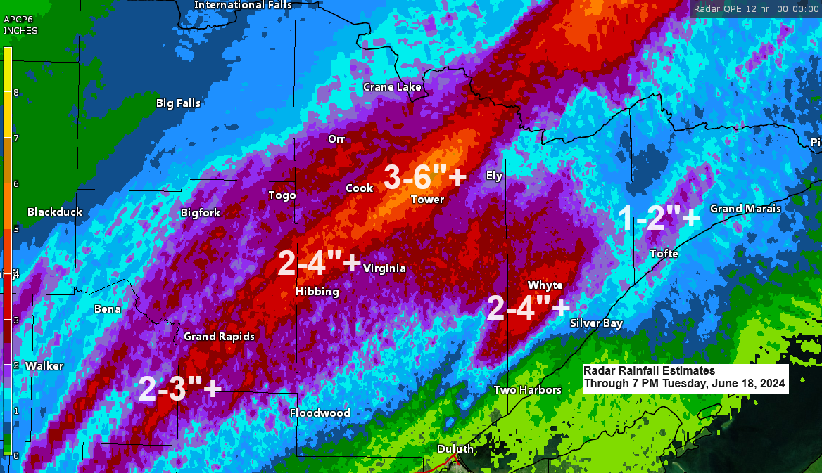
-The most intense flash flooding is occurring from Cook to Tower and north, including areas around Lake Vermillion where 4 to 6 inches or more of rain has fallen, and rain continues to fall as of 6:30 PM Tuesday.
-Significant flooding is expected to develop along the North Shore of Lake Superior as well.
-Rivers and streams will rise rapidly overnight which could cause new areas of flooding.
Additional Storm Reports from Tuesday, June 18, 2024
- 7:48 PM: Flash Flood. 1 ESE Gilbert, MN (St. Louis County) Flooding on Minnesota Highway 135 just east of Gilbert.
- 7:06 PM: Flash Flood. 2 SSE Hibbing, MN (St. Louis County) Water in resident driveway.
- 7:04 PM: Flash Flood. 2 E Mountain Iron, MN (St. Louis County) Water in yard covering driveway and backed up to buildings for a couple houses in this area.
- 6:28 PM: Flash Flood. 1 ESE Gilbert, MN (St. Louis County) Highway 135 flooded between MN 37 and Heritage Trail.
- 6:00 PM: Flash Flood. 8 WNW Tower, MN (St. Louis County) Breezy Point Road complete washout. At least 8 feet across.
- 5:56 PM: Flash Flood. 7 E Side Lake, MN (St. Louis County) Flooding on Minnesota Highway 73 between Forest Road 272 and Osborn Road.
- 5:52 PM: Flash Flood. 2 ENE Angora, MN (St. Louis County) Flooding on Minnesota Highway 1 in both directions. Between Sassas Road and Brown road.
- 5:42 PM: Flash Flood. 5 E Angora, MN (St. Louis County) Flooding on Minnesota Highway 1 in both directions between Brown Road and County Road 361.
- 5:40 PM: Flash Flood. 7 SW Shermans Corner, MN (St. Louis County) A few inches of water over residential gravel road.
- 5:25 PM: Flash Flood. 6 SSE Marcell, MN (Itasca County) Flooding on road between County Highway 28 and Forest Road 2373.
- 5:25 PM: Flash Flood. 1 SW Ely, MN (St. Louis County) East Pattison Road completely under a foot of water.
- 5:21 PM: Flash Flood. 3 SSW Angora, MN (St. Louis County) Flooding on Minnesota Highway 53 at Hannula Road.
- 5:16 PM: Flash Flood. 1 S Hibbing, MN (St. Louis County) Business Highway 169 covered completely with at least a foot of water. Water up to the front of steps of some homes.
- 5:10 PM: Flash Flood. 1 NW Chisholm, MN (St. Louis County) Significant curb to curb street flooding across Chisholm.
- 5:05 PM: Flash Flood. Hibbing, MN (St. Louis County) Streets covered completely with at least a foot of water.
- 4:20 PM: Flash Flood. 7 W Tower, MN (St. Louis County) Highway 1 between Tower and Cook had spots with water across the road and a spot with only one lane opened. There is also a spot on Hwy 22 that has water flowing across it.
- 4:11 PM: Flash Flood. 1 SW Ely, MN (St. Louis County) Pattison St and 2nd Ave E, Ely, MN; street flooding including water flowing out of storm drain.
- 3:25 PM: Funnel Cloud. 15 N Robinson, MN (St. Louis County) Funnel cloud seen looking NW from Moose Lake in the BWCA. Persisted for roughly 2-3 minutes.
Rainfall Reports from Tuesday, June 18, 2024, as of 6:50 PM
1 E Iron Junction, MN: 5.00″
Mckinley, MN: 4.26″
Cook, MN: 4.01″
3 S Cohasset, MN: 3.91″
2 SW Side Lake, MN: 3.90″
Nashwauk, MN: 3.87″
1 NW Chisholm, MN: 3.82″
Grand Rapids, MN: 3.72″
Orr, MN: 3.62″
Skibo, MN: 3.58″
5 NNE Cook, MN: 3.30″
Hibbing, MN: 3.22″
Eveleth-Virginia, MN: 3.18″
Cass Lake, MN: 3.15″
Ely, MN: 2.87″
Bigfork, MN: 2.82″
Isabella, MN: 2.47″
Hill City, MN: 2.31″
Winton, MN: 2.23″
2 SSW Ely, MN: 2.22″
International Falls, MN: 1.59″
Littlefork, MN: 1.54″
Bay of Grand Marais, MN: 1.27″
Walker, MN: 1.00″
Brainerd, MN: 0.95″
Aitkin, MN: 0.91″
McGregor, MN: 0.74″
Saginaw, MN: 0.66″
Duluth Airport: 0.37″
Moose Lake, MN: 0.34″
Hinckley, MN: 0.18″
The Northland experienced an extraordinary amount of moisture late this afternoon, with precipitable water levels reaching 2 inches or more, which is about the maximum typically observed in this region.

A cold front is now moving more swiftly out of central Minnesota this evening. However, until it fully passes, the Northland will still experience frequent showers and thunderstorms, resulting in heavy downpours.

Radar loop ends 7:34 PM Tuesday, June 18, 2024.
The showers and thunderstorms are expected to subside from west to east by late this evening, and Wednesday is anticipated to be a dry day, providing a break from the recent very wet conditions.
HRRR model simulated radar forecast through 7 AM Wednesday.

Thanks for reading!
Tim
Leave a Reply