5:42 PM Wednesday, July 24, 2024
The Northland is experiencing a gradual warm-up, with widespread temperatures in the 70s today. These will give way to upper 70s and lower 80s on Thursday. The warming trend is expected to continue, with widespread 80s forecasted from Friday through the weekend, and there’s even a possibility of temperatures reaching into the 90s in some areas, particularly on Saturday.
The warmer weather pattern is expected to persist throughout much of next week.
In the coming days, humidity is expected to increase, with dew point temperatures ranging from the 60s to around 70 on Friday and staying in the 60s and 70s over the weekend.
Scattered showers and thunderstorms are expected mainly in north central Minnesota on Saturday, with the possibility extending south and east to include eastern Minnesota and northwest Wisconsin during the late Sunday afternoon to Monday period. These rain chances are associated with a cold front anticipated to move eastward out of the Dakotas at a slow pace this weekend. Note: The likelihood of severe weather this weekend currently seems low, yet there’s a possibility for isolated stronger storms to occur on both Saturday and Sunday.
Once again, it appears that most of the showers and thunderstorms from Saturday into early Sunday morning will remain over northern Minnesota, while dry conditions are expected to continue in northwest Wisconsin, eastern Minnesota, and the Twin Ports area.

The Northland region is experiencing a rainfall deficit of 1 to 2 inches this month, whereas International Falls stands out with its rainfall exceeding the normal by slightly over 1.25 inches.
Rainfall anomalies for July 2024 as of 4 PM on the 24th
- International Falls, MN: +1.30 inches above normal
- Duluth, MN: -1.96 inches below normal
- Hibbing, MN: -1.95 inches below normal
- Brainerd, MN: -1.43 inches below normal
- Ashland, WI: -0.93 inches below normal
Make a one-time donation
Make a monthly donation
Make a yearly donation
Choose an amount
Or enter a custom amount
Your contribution is appreciated.
Your contribution is appreciated.
Your contribution is appreciated.
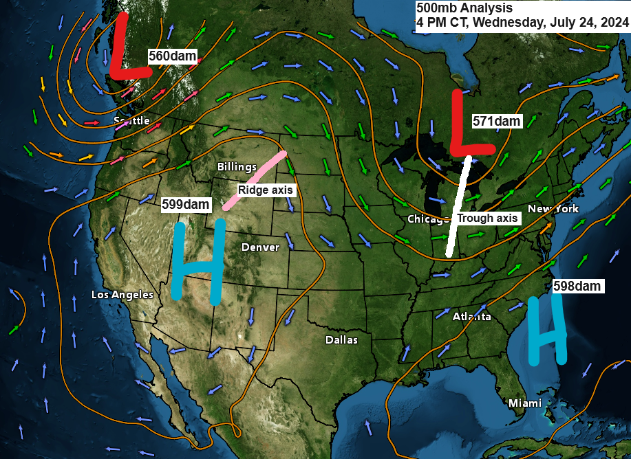
The northwest flow aloft persisted today over the upper Midwest. Meanwhile, the trough that lingered over the region in recent days has moved further east, making way for an upper-level ridge that is advancing northeastward from the western High Plains and the northern Rockies.
Note: The 500mb heights at the core of the upper ridge over the western U.S. are approaching an impressive 6000 decameters this afternoon.

The western U.S. experienced widespread heat today, with 850mb temperatures ranging from +30 to +35C. In contrast, the upper Midwest enjoyed a pleasant airmass, with 850mb temperatures around +12C this afternoon.

Montana is experiencing significant heat this afternoon.
- Glasgow: 108
- Jordan: 107
- Miles City: 107
- Havre City: 105
- Billings: 105
- Great Falls: 101
The heat wave’s eastern reach extended into the western Dakotas this afternoon, with temperatures ranging from the mid-90s to the low 100s.

Thanks for reading!
Tim
Leave a Reply