4:41 PM Friday, July 26, 2024
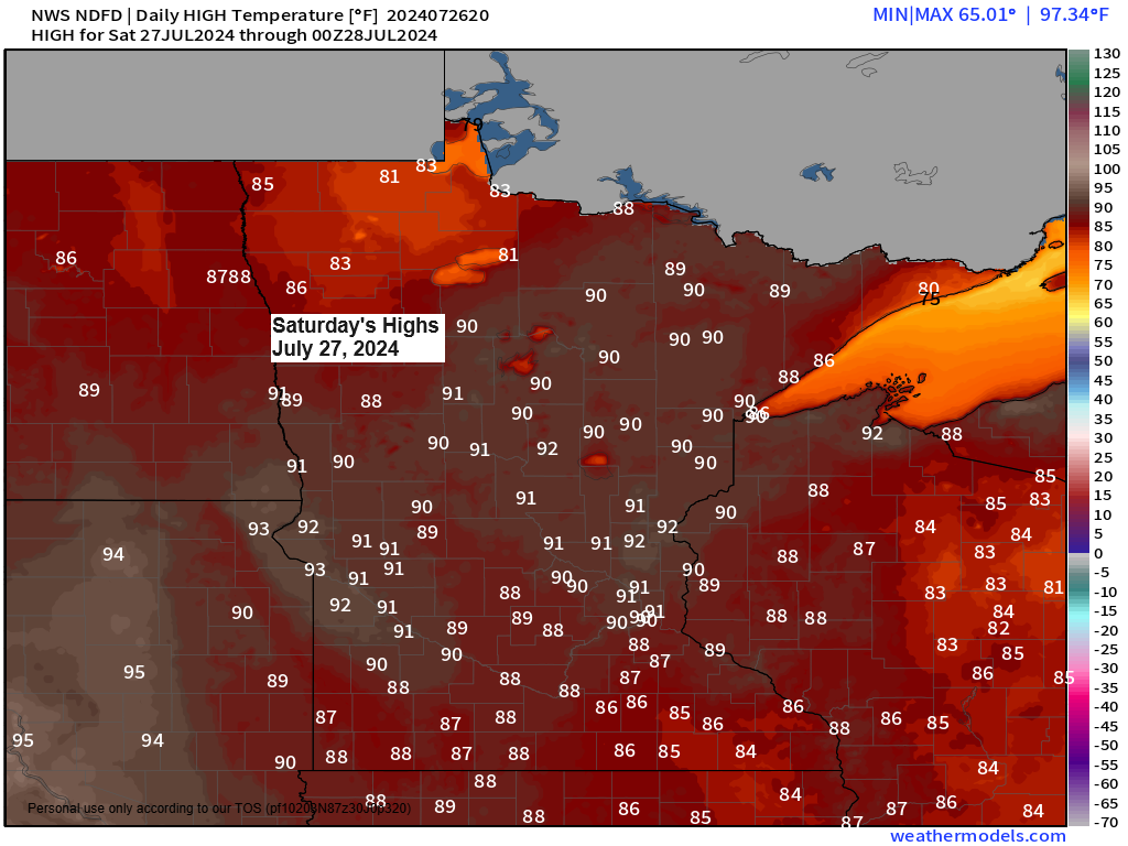
Northeast Minnesota and northwest Wisconsin are expected to experience a very warm and humid weekend, with temperatures ranging from the 80s to the lower 90s. The highest temperatures are anticipated on Saturday.
Late tonight and on Saturday, northern Minnesota is forecasted to experience scattered showers and thunderstorms, with the potential for isolated severe storms. The rest of northeast Minnesota including the Twin Ports and all of northwest Wisconsin should stay dry tonight and Saturday, although there is a chance that we could see a few isolated showers and thunderstorms develop Saturday afternoon-early evening in parts of northwest Wisconsin and far eastern Minnesota.
The likelihood of scattered showers and thunderstorms will persist on Sunday, primarily in north central Minnesota. However, the probability of rain will also rise gradually in northwest Wisconsin and eastern Minnesota, including the Twin Ports area, by late Sunday afternoon or evening.
Make a one-time donation
Make a monthly donation
Make a yearly donation
Choose an amount
Or enter a custom amount
Your contribution is appreciated.
Your contribution is appreciated.
Your contribution is appreciated.
Today, the Northland experienced very warm temperatures, with widespread 80s throughout the region. Even warmer conditions were present farther west, with 90s in eastern North Dakota and a mix of 90s and some 100s across much of South Dakota this afternoon.
Note: 12 days so far this month with a high of at least 80 degrees in Duluth. Average in July is 11 days at or above 80.

The warm temperatures are accompanied by notable humidity, with dew points ranging in the mid-60s to low 70s this afternoon. In western Minnesota, dew points are even reaching the mid and upper 70s.
The humid air mass is anticipated to remain in the Northland throughout the weekend and for much of the following week, as it currently appears. Daily dew points are predicted to vary between approximately 64 and 74 degrees during the specified period with the highest dew points expected this weekend.

The mix of high temperatures and elevated dew points is resulting in heat index values between 95 and 105 degrees this afternoon across central and western Minnesota, as well as the eastern Dakotas.

Isolated, strong to severe thunderstorms are possible late tonight into Saturday across parts of north-central Minnesota or in the dark green area on the map. The primary severe weather threats include large hail, ranging from quarter to ping-pong ball size, and damaging wind gusts up to 60 mph.

The high moisture levels in the air pose a risk for torrential rainfall and potential flooding this weekend. The greatest likelihood of this occurring is on Sunday, extending from central to northern Minnesota, specifically in the areas marked yellow on the map.
Note: Repeated rounds of thunderstorms are expected to pass over the same areas in central and northern Minnesota on Sunday, heightening the risk of flash flooding.
Excessive Rainfall Outlook valid 7 AM Sunday to 7 AM Monday, July 28-29, 2024.

HRRR model simulated radar forecast valid from 10 PM tonight to 10 PM Saturday.

Rainfall totals of a quarter to half an inch with localized amounts of an inch or more are possible Saturday-early Sunday morning across northern Minnesota.

After about a week, the upper-level ridge that was over the western U.S. has finally moved eastward into the upper Midwest, with 500mb heights reaching approximately 590 decameters today.
The upper Midwest has transitioned from a north-northwest flow to a southwest flow aloft today, marking a shift in the weather pattern.

An impressive weather system is active over northern Saskatchewan, Canada today.
Goes-16 visible satellite loop ending 4 PM CT Friday, July 26, 2024.

Observations of 850mb temperatures indicate a broad swath of warmth extending from the Western United States to the Upper Midwest, with temperatures ranging approximately from +24 to +33 degrees Celsius today.

Thanks for reading!
Tim
Leave a Reply