4:21 PM Sunday, August 11, 2024
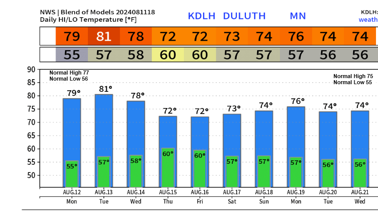
The upcoming days in the Northland are expected to maintain mild temperatures, with highs ranging from the mid-70s to around 80 degrees. However, there is a possibility of cooler weather later in the week, though it may not be as cool as the temperatures experienced in the previous week.
August has begun with cooler temperatures in the Northern Plains and Upper Midwest, extending to the Northland area.
Temperature deviations in the Northland for August 2024 up to the 10th.
- International Falls, MN: -4.0 degrees below normal
- Brainerd, MN: -3.4 degrees below normal
- Hibbing, MN: -2.6 degrees below normal
- Duluth, MN: -2.5 degrees below normal
- Ashland, WI: -1.1 degrees below normal
Note: So far this summer, Duluth has experienced 21 days with high temperatures reaching at least 80 degrees. On average, Duluth sees 23 days with highs of at least 80 degrees during the summer months of June through August.

The upper low and trough that have been impacting the Northland over the past few days have now shifted into eastern Canada. However, a persistent north to northwest flow aloft remains, contributing to unsettled weather conditions, including cloudiness and occasional showers this afternoon.

This afternoon, a few showers developed and moved southeast across parts of the Northland. If you happened to be under one of these showers, you might have experienced a brief but heavy downpour.
Radar loop ends 4:04 PM CT Sunday, August 11, 2024.
Goes-16 water vapor loop ending 3:26 PM CT Sunday, August 11, 2024.

Make a one-time donation
Make a monthly donation
Make a yearly donation
Choose an amount
Or enter a custom amount
Your contribution is appreciated.
Your contribution is appreciated.
Your contribution is appreciated.
Temperatures have significantly increased compared to the past few days, which saw several locations in the Northland either setting or matching their record cold high temperatures.
Today’s high temperatures were typically in the mid to upper 70s across northeast Minnesota and northwest Wisconsin, aligning with the expected norms for mid-August.

Rain may occur later this week as an upper-level and surface system move across the upper Midwest.
Note: At present, it appears that this coming Thursday and Friday are the most likely days to receive rainfall in the Northland area. However, the possibility of a few showers on Monday, similar to those that occurred Sunday afternoon, cannot be dismissed.

Preliminary rainfall estimates for the upcoming system indicate that a significant portion of northeast Minnesota and northwest Wisconsin may receive approximately a quarter to a half-inch of rain with locally higher amounts possible. This event is expected to take place mainly on Thursday and Friday of this week.

Thanks for reading!
Tim
Leave a Reply