5:15 PM Sunday, December 1, 2024
I’ve had a few people sign up for my Black Friday promotion, which will run until Friday, December 6, 2024. Thank you for subscribing! The annual subscription is now offered at $35, reduced from $60. With a subscription, you gain access to my detailed snowfall forecasts and comprehensive analysis of weather systems affecting the Northland. You can find the subscription link further down in this post.
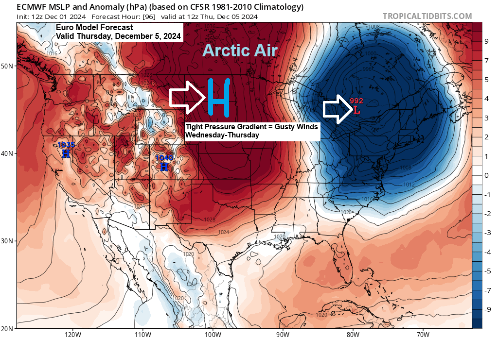
Another wave of arctic air is expected to sweep through the Northland from Wednesday afternoon and persist until Friday. Along with this fresh influx of cold, gusty winds ranging from 15 to 30 mph are anticipated from Wednesday to Thursday. These conditions are likely to drive wind chill temperatures down to the teens and 20s below zero across the Northland by Wednesday evening into Thursday morning.
The 500mb forecast from the EPS model, valid from 6 AM Wednesday to 6 AM Thursday, indicates another potent upper low swiftly moving southeast across the Great Lakes. This will usher in another surge of arctic air into the Northland by midweek.

A clipper is moving southeast across the Dakotas today, bringing snowfall to parts of North Dakota. This snow is expected to spread southeast into west central and southern Minnesota tonight. However, the snow associated with this clipper system is anticipated to bypass the Duluth area tonight.
Radar loop ends 4:14 PM CT Sunday, December 1, 2024.
Tonight, a clipper system is expected to bring a trace to 1.5 inches of snow across areas of eastern North Dakota, eastern South Dakota, and into western and southern Minnesota.
More lake effect snow is expected tonight and Monday morning off Lake of the Woods in northwest Minnesota, with accumulations of 1-4 inches, and along the South Shore of Lake Superior in northwest Wisconsin, where accumulations could exceed 4 inches in some locations from around Hurley and Gile on east.


Subscribe to continue reading
Become a paid subscriber to get access to the rest of this post and other exclusive content.