5:44 PM Monday, December 9, 2024
The Northland is bracing for a return of colder temperatures in the coming days, with forecasts predicting a particularly frigid stretch from mid to late week.
The initial surge of cold air is currently moving south and east out of western Minnesota. However, the genuine Arctic air is not expected to reach the Northland until Wednesday.
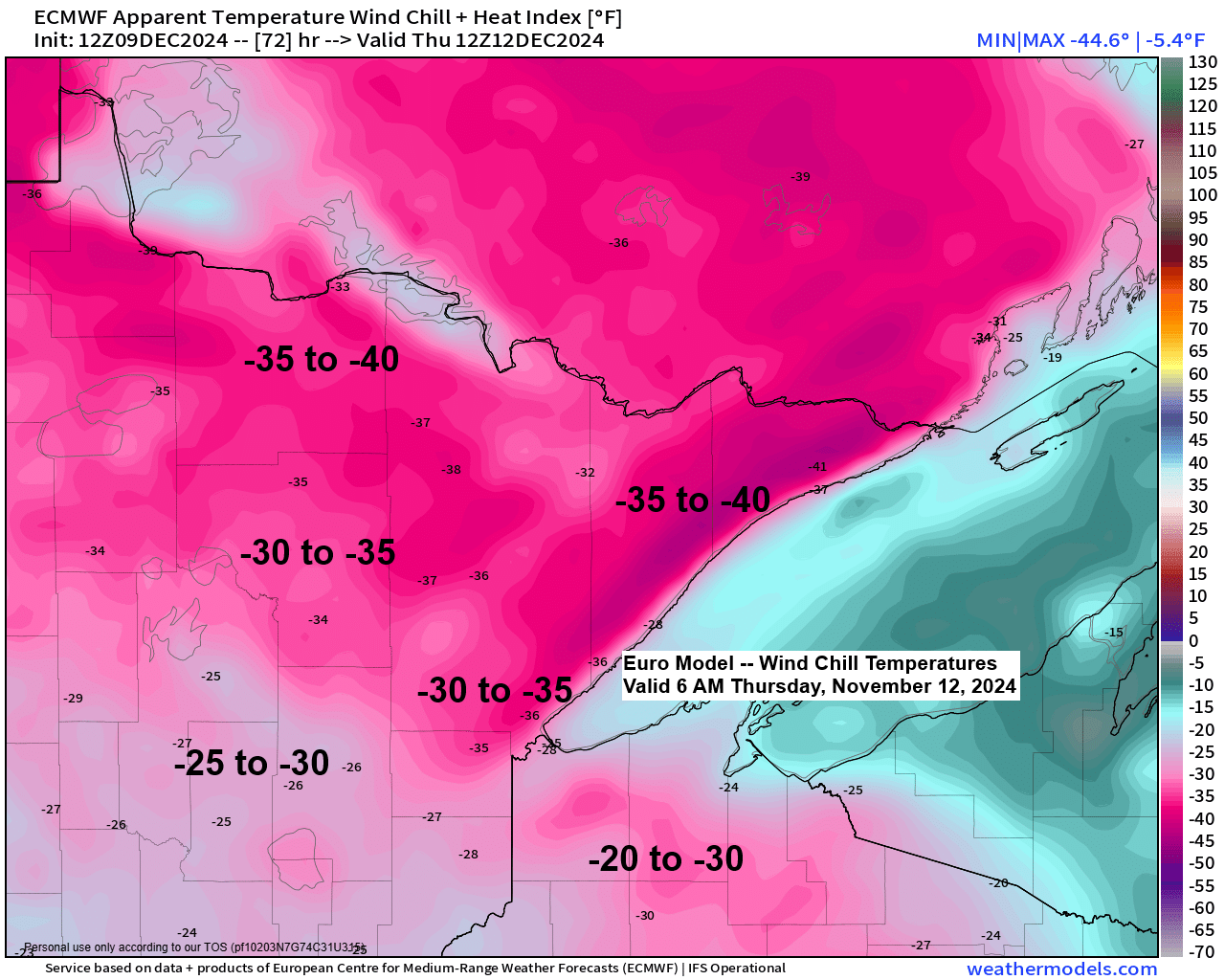
The forecast for the Northland on Wednesday predicts high temperatures in the single digits and teens, while Thursday’s highs are expected to vary from about 5 below to 5 above zero. The low temperatures on Wednesday and Thursday night are anticipated to fall between the single digits and the 20s below zero.
Wind chill values in the Northland are expected to plummet to between -15 and -40 degrees from Wednesday afternoon through Friday morning, with the coldest wind chills anticipated between Wednesday night and Thursday morning.
Observe the stark temperature contrast this afternoon, with readings around 15 degrees in northwest Minnesota and 50 degrees in eastern Wisconsin.

Scattered snow showers are moving southeast across the Northland this evening, following the low-pressure system that caused widespread snow, rain, and mixed precipitation in the area on Sunday.
While widespread snow accumulation is not expected tonight, some areas may receive up to half an inch or an inch of snow tonight.
Radar loop ends 5:04 PM Monday, December 9, 2024.
The northwest flow aloft is set to bring back arctic air to the Northland this week. The onset of this arctic air mass is already noticeable far to the north today, with 850mb temperatures dropping to -17°C, and they are expected to plummet even further in the coming days.

Observe how the upper low/trough, moving towards the upper Midwest from the northwest, intensifies midweek while traversing the Great Lakes, as indicated by the green and blue colors on the loop below.
EPS model 500mb forecast valid 6 AM Tuesday to 6 AM Friday, December 10-13, 2024.

The Northland may experience additional snowfall from Tuesday evening into Wednesday before the arrival of arctic air.
While the expected snowfall may not be substantial, the drop in temperatures could lead to slippery conditions on the roads Tuesday evening and into Wednesday.
NAM 3km model simulated radar forecast valid 12 PM Tuesday to 6 PM Wednesday.


Subscribe to continue reading
Become a paid subscriber to get access to the rest of this post and other exclusive content.