5:42 PM Tuesday, December 10, 2024
An arctic air mass is advancing from the northwest, as evidenced by the 850mb temperature plummeting to approximately -30°C this afternoon over parts of Manitoba, Canada. Concurrently, 500mb heights have descended to roughly 506 decameters near the heart of this arctic air mass and in proximity to an upper-level low that is tracking south-southeastward toward the Northland.

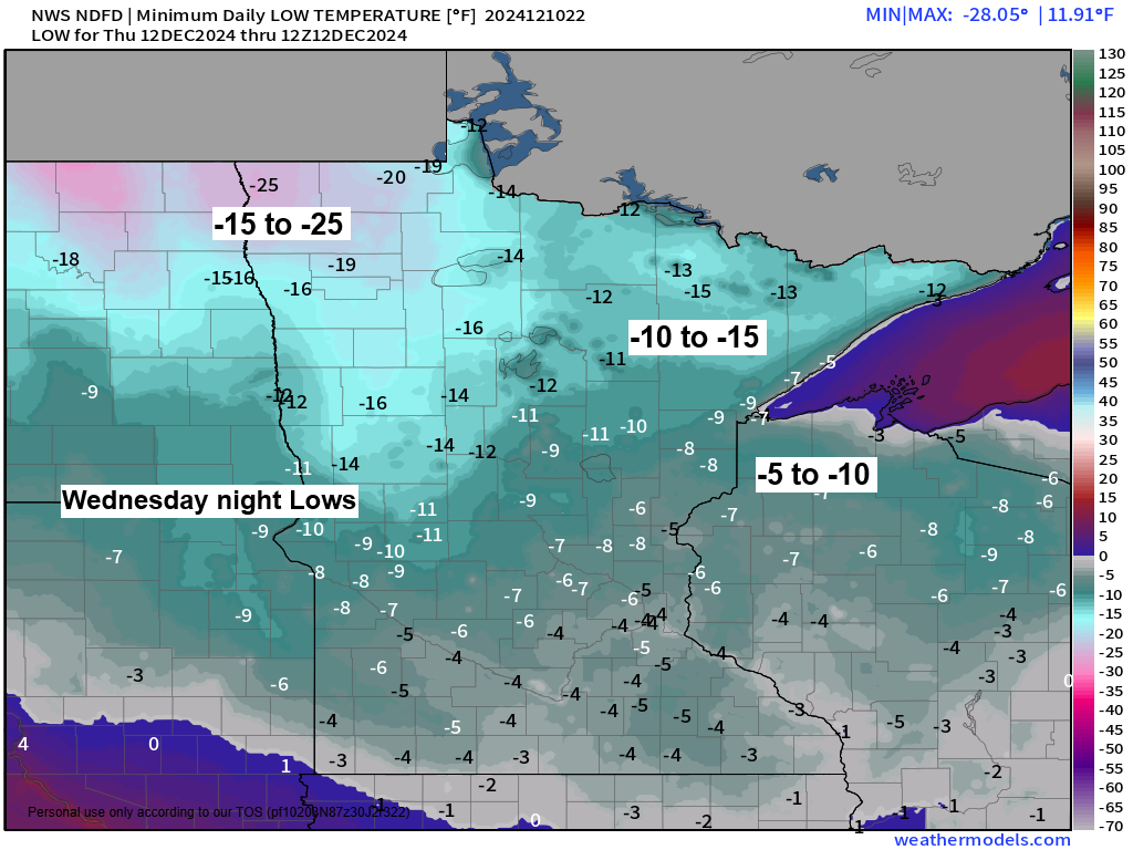
Temperatures to the northwest varied between zero and -15 degrees this afternoon. This cold air mass is moving southeast and will cover the Northland on Wednesday and Thursday, with Thursday expected to be the colder of the two days with highs on that day ranging from the single digits below to around 5 above zero.
Note: Duluth typically experiences nine days of subzero low temperatures in December. Although there haven’t been any this month yet, it’s expected that this will change shortly.

Northwest winds escalating to 10 to 20 mph, with gusts reaching 30 mph, along with the bitter cold, will result in wind chill temperatures plummeting to between 15 and 40 degrees below zero throughout the Northland from Wednesday into Thursday.
HRRR model wind chill forecast valid 6 AM Wednesday to 12 PM Thursday.

Before the arrival of the arctic air, some snowfall is expected as a cold front moves southeast across the Northland. While the snow accumulation is anticipated to be fairly light, the combination of light snow and cold temperatures may lead to hazardous travel conditions tonight and into Wednesday.
Significant snow accumulations are expected along the South Shore of Lake Superior in northwest Wisconsin from late tonight through Wednesday evening. The cold air moving across the warmer waters of Lake Superior, combined with northwest winds, will result in lake effect snow for parts of the South Shore.
Lake effect snow showers may also occur downwind of the larger inland lakes in northern Minnesota, continuing through Wednesday.
NAM 3km model simulated radar forecast through 6 AM Thursday.

The majority of the Northland is expected to receive a trace to an inch of snow by Wednesday, with certain areas potentially seeing as much as 2 inches.
Significant snowfall, varying from 2 to 10 inches or even higher, is expected in the snowbelt regions along the South Shore of Lake Superior.

Winter Storm Warnings and Winter Weather Advisories will be in effect from late tonight through Wednesday night for areas along the South Shore of Lake Superior, due to expected lake-effect snow.


Computer models concur on an upper-level wave moving east-northeast from the central Rockies on Friday, yet they vary on the extent of northward moisture movement. This variation will dictate whether parts of the Northland will experience snow late Friday night into Saturday, or remain mostly dry with precipitation staying further south.


Subscribe to continue reading
Become a paid subscriber to get access to the rest of this post and other exclusive content.