6:32 PM Wednesday, December 11, 2024
The last occurrence of temperatures dropping to -20 degrees Fahrenheit or colder in Duluth was on February 3, 2023, when the low reached -22 degrees. The likelihood of experiencing -20 degrees or colder in Duluth tonight and Thursday night is relatively low but certainly can’t be ruled out.
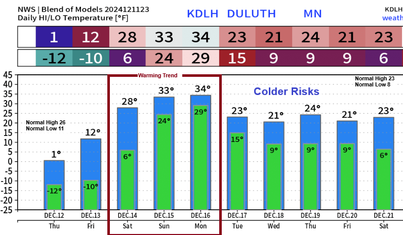
Duluth is facing a fluctuating temperature forecast, with the arctic chill expected to persist until Friday. Following this, a notable increase in temperatures is anticipated over the weekend and into early next week, with highs potentially reaching or exceeding the freezing mark by Sunday or Monday. However, there is a possibility that colder, more arctic air may return sometime between mid to late next week.
A frigid airmass will persist over the Northland through Friday; however a notable moderation in temperatures is expected this weekend.
Temperatures of -25 to -30°C this evening in the 850mb layer are expected to rise to approximately 0°C by Saturday afternoon.
NAM 850mb temperature forecast valid through 6 PM Saturday.

An upper-level low, with 500mb heights dropping to 506 decameters, continues to move south-southeast into the Northland early this evening.
The 850mb temperatures did not quite reach -30°C (yet) near the core of this Arctic airmass, but they are close, with readings dropping to -29°C early this evening.

The subzero temperatures are widespread this afternoon.

Frigid wind chills in the teens, twenties, and thirties below zero are affecting a large area late this afternoon.

Winds are expected to remain gusty tonight and on Thursday, ranging from 10 to 15 mph, with gusts reaching up to 30 mph.
Wind chills ranging from around -20 to -40 degrees will be common in the Northland tonight into Thursday morning, and in the teens and 20s below zero Thursday afternoon.
HRRR model wind chill forecast through 6 PM Thursday.

Lake effect snow showers are expected to persist tonight into Thursday morning along the South Shore of Superior in northwest Wisconsin, with the potential for an additional 4 inches of snow, particularly over the Bayfield Peninsula.
Lighter lake effect snow may also be observed downwind of some of the larger inland lakes across northern Minnesota tonight.

I am still monitoring the computer models on the trajectory of a wave emerging from the central-southern Rockies on Friday; however, the path of this system seems to be considerably far to the south, which should restrict the amount of precipitation expected in certain areas of the Northland on Saturday.
It should also be noted that some of the computer model runs from the last few days have indicated a system affecting the Northland sometime around December 16-18. However, there have been extremely wild fluctuations from one model run to the next regarding this potential system, resulting in very low confidence for early next week regarding whether a system will impact the Northland.


Subscribe to continue reading
Become a paid subscriber to get access to the rest of this post and other exclusive content.