6:12 PM Friday, January 3, 2025
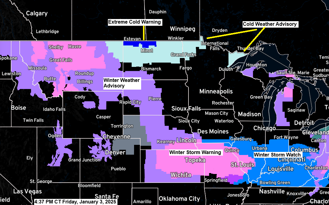
A variety of winter weather alerts are currently in effect, extending from the northern Rockies and northern Plains into the central Plains and Ohio Valley..
- Winter Storm Warnings (pink) and Winter Weather Advisories (purple) cover parts of the following states, Montana, North Dakota, South Dakota, Wyoming, Nebraska, Kansas, Illinois, and Missouri.
- Winter Storm Watch (blue) covers parts of the Midwest and Ohio Valley including pretty much all of Kentucky.
- A small part of southern Missouri is under an Ice Storm Warning (purple)
Furthermore, an extreme cold warning (darker blue) is in effect for parts of northern North Dakota with wind chill temperatures as low as -44 degrees Fahrenheit. Additionally, a cold weather advisory (lighter blue) covers parts of Montana, the northern half of North Dakota, northwest Minnesota, as well as the North Shore and Arrowhead region in northeast Minnesota with wind chills ranging from -30 to -35 degrees.
And finally, there’s a wind advisory in effect for the Arrowhead region of Minnesota, including Grand Marais, with northwest winds gusting up to 45 mph. These strong winds may cause tree limbs to be blown down and could result in a few power outages tonight into Saturday morning.
Colder air continues to move into the Northland today; however, when examining 850mb temperatures, the lowest they reach in our region is approximately -17 to -19°C. Typically, during periods of arctic air, 850mb temperatures can drop as low as -25 to -30°C or even colder.

This afternoon, temperatures range from approximately zero in far northern Minnesota to the lower teens in east central Minnesota and northwest Wisconsin.
Significantly colder temperatures were observed farther to the northwest, with temperatures ranging from the teens to 20 degrees below zero this afternoon in parts of western and central Canada.

A major winter storm is expected this weekend, from Saturday to Monday, affecting parts of the central Plains to the Ohio Valley.
A swath of 6 inches or more of snow is likely in the purple outlined area on the map, while just south of the heavy snow, significant ice accumulations of a quarter to half an inch are expected.
Note – The storm track has shifted a little further south in model guidance today compared to 24 hours ago.

Here’s a look at this weekend’s winter storm on Goes-18 infrared satellite imagery with the loop ending at 5:45 PM CT Friday, January 3, 2025.

European model simulated radar forecast valid 6 AM Saturday to 6 PM Monday.
Blue – Snow
Green – Rain
Pink – Wintry Mix


Subscribe to continue reading
Become a paid subscriber to get access to the rest of this post and other exclusive content.