7:55 PM Saturday, January 4, 2025
Note – Duluth, Minnesota’s snowfall deficit for the 2024-25 season is at 24.1 inches below normal to date, and that number will continue to increase in the foreseeable future.
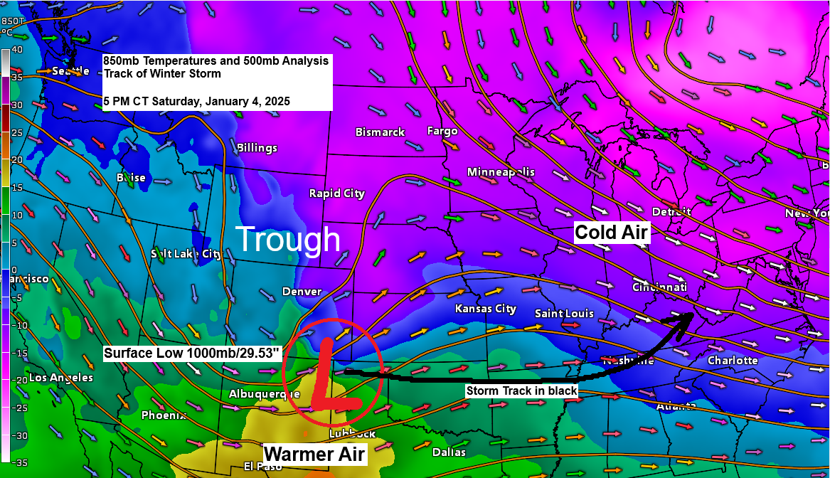
A powerful winter storm will impact a large area from the central Plains to the Mid-Atlantic over the next few days. This storm will produce widespread heavy snow and gusty winds, significant amounts of freezing rain and ice accumulations, as well as the potential for severe thunderstorms and a few tornadoes on Sunday over parts of the lower to mid-Mississippi Valley and central Gulf Coast states.
Widespread power outages and road closures are possible in parts of the central Plains, Ohio Valley and mid-Atlantic the next few days due to this high impact winter storm.
One factor contributing to this winter storm is the widespread cold, arctic air descending south from Canada, while warmer air and moisture advects north from the southern Plains.
Widespread winter weather alerts are in effect including a blizzard warning for much of southern, central and northern Kansas, far southern Nebraska and northwest Missouri.
Note – I’m not sure what’s going on in central Indiana, maybe the folks at the NWS are stocking up on pizzas and beverages, but there’s also a winter storm warning for that area including Indianapolis and Bloomington but for some reason it’s not showing up on this image.

HRRR model (18z run) simulated radar forecast through 12 PM CT Monday.
Blue – Snow
Green – Rain
Pink/Purple – Sleet and Freezing Rain

Forecast Snowfall Totals
Regarding snowfall totals from this winter storm, we’re generally expecting widespread accumulations of 6 to 12 inches or more, with lower amounts to the north and south of the heaviest snow area. Note: There are some model solutions showing upwards of 18 to 24 inches of snow in a few areas from north central Kansas to south central Indiana.
NAM 3km model forecast below

Ice Storm
Ice accumulations ranging from around 0.10 to 0.25 inches are anticipated in the yellow, orange, and red shaded areas, with higher amounts of up to 0.50 inches possible in parts of southern Missouri.

The Northland will continue to experience cold weather, with lows tonight ranging from around 5 below to 20 below zero. Subzero low temperatures are expected to persist through about mid-week.
Highs will generally be in the single digits and teens over the next few days.
Although we are experiencing below-normal temperatures, this cold outbreak could be significantly worse if we had a deeper snowpack.
Areas in blue on the map below are in a Cold Weather Advisory from late tonight through about mid-morning Sunday. For those not aware, the National Weather Service changed their wind chill headlines to cold weather advisories or extreme cold warnings.
For this particular cold weather advisory wind chill temperatures are forecast to range from around 25 below to 35 below zero.

Wind Chill Forecast
HRRR model wind chill temperatures from 9 PM tonight to 12 PM Sunday.

Snowfall totals ranging from a trace to 1 inch are possible in northeast Minnesota and northwest Wisconsin over the next 7 days, with the majority of that, if it occurs, expected between Thursday and Saturday (9th-11th).

Make a one-time donation
Make a monthly donation
Make a yearly donation
Choose an amount
Or enter a custom amount
Your contribution is appreciated.
Your contribution is appreciated.
Your contribution is appreciated.
Extremely cold temperatures enveloped much of northwest Canada today, with readings ranging from approximately 35 to 45 degrees below zero.
Yakutsk, Russia experienced a “warm-up” with a temperature of 36 degrees below zero as of 9 AM Sunday. This location had witnessed temperatures in the -50s and even -60s over the past several days.

Winter storm getting its act together this afternoon.
Goes-16 water vapor loop ending 6:45 PM CT Saturday, January 4, 2025.

Widespread snow (blue) and freezing rain/drizzle (pink) early this evening and it’s only going to get worse over the next 24 hours.
Radar loop ends 6:20 PM CT Saturday, January 4, 2025.
Risk of severe thunderstorms Sunday
There is an Enhanced Risk (level 3/5) and a Slight Risk (level 2/5) for severe thunderstorms on Sunday in the orange and yellow areas, respectively, on the map below.

A few tornadoes are possible on Sunday, particularly in the yellow and brown shaded areas on the map. Damaging winds are also a potential threat.

Thanks for reading!
Leave a Reply