6:42 PM Thursday, January 16, 2025
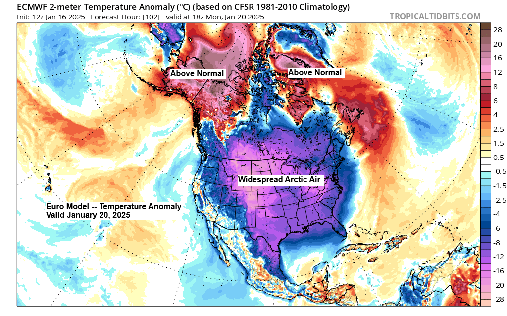
-The first and probably most significant shot of Arctic air arrives this weekend and continues into early next week.
-Odds are increasing that we will see low temperatures in the -30s across northern Minnesota Sunday night and Monday night, with even a chance of -40 degrees.
-Temperatures are forecast to drop below zero in Duluth starting late Friday night/early Saturday morning, and we may not see temperatures climb above zero again until sometime late Tuesday or Wednesday.
-Some milder temperatures could make a comeback around the middle to end of next week, but more cold Arctic air looks to return at times next weekend into the final week of January.
– February 3, 2023, was the last time Duluth recorded a temperature of -20 degrees or colder, with a low of -22 degrees.
-February 13, 2021, was the last time Duluth recorded a temperature of -30 degrees or colder, with a low of -35 degrees.
Note: I don’t think we will see temperatures as cold as -30 in Duluth, but -20s look quite likely this weekend and early next week.
*The average temperature so far this month in Duluth is 7.8 degrees, which is -3.8 degrees colder than normal. With more cold air to come, the average temperature for the month will continue to drop.
*January 2025 is doing something we haven’t seen in Duluth since July 2023, and that’s a below-average temperature month. That’s right, July 2023 was the last time Duluth’s average temperature for the entire month finished colder than normal with a temperature anomaly of -1.5 degrees.
Arctic air and low 500 mb heights appear in blue and green, while milder temperatures and high 500 mb heights are shown in orange, red, and white on the loop.
EPS model 500mb forecast through January 31, 2025.

Temperatures at 500 mb (~18,000 feet) will be dropping to around -43 to -47°C in much of the Northland from Sunday into Monday as this arctic airmass moves over the area.
To put this into perspective, temperatures in the -40s°C at 500 mb would be approximately -3 sigma in the upper Midwest.
Euro model 500mb temperature forecast shown below

The arrival of colder air and an arctic front on Friday will help to steepen the lapse rates across the Northland, and this could lead to some scattered snow showers/snow squall development during the day.
Snow accumulations should be minor <1″, but if snow squalls develop, they could cause brief near whiteout conditions on Friday.

Strong northwest winds will develop across the Northland on Friday, with gusts of 20 to 45 mph. Patchy blowing snow could develop Friday, especially if we do get some snow showers.
HRRR model wind gust forecast valid 6 AM Friday to 6 AM Saturday.

Arctic air spreads southeast across the Northland starting Friday afternoon as 850 mb temperatures quickly fall.
In Duluth, 850 mb temperatures will drop from around +3°C at 7 AM Friday to -16°C at 7 PM Friday to -25°C at Noon Saturday, and they will drop even further Saturday night into Monday.
HRRR model 850mb temperature forecast valid 6 AM Friday to 12 PM Saturday.

Check out how much warmer temperatures were in the Northland at 3:30 AM this morning compared to the same time on Wednesday.
We had temperatures 35 to nearly 50 degrees warmer this morning than on Wednesday morning.

And those mild temperatures carried over into this afternoon with upper 20s and low to mid 30s widespread in the Northland.
Lots of wind accompanied these milder temperatures today, with the strongest winds occurring prior to noon — peak wind gusts below.
- Duluth, MN: 46 mph
- Hibbing, MN: 43 mph
- International Falls, MN: 37 mph
- Brainerd, MN: 35 mph
- Ashland, WI: 28 mph

Ice coverage on Lake Superior is starting slowly this winter, with only about 5% of the lake covered by ice, compared to the usual 15% by mid-January.

Any big snows on the horizon? Plus, an updated snow depth map for Minnesota is found below.

Subscribe to continue reading
Become a paid subscriber to get access to the rest of this post and other exclusive content.