5:35 PM Monday, January 20, 2025
The good news is that the coldest part of this Arctic blast is now sitting over the Northland, meaning it will start to move off to the east. However, that won’t begin to happen until Tuesday afternoon, so until then, expect another bitterly cold night and another frigid day on Tuesday.
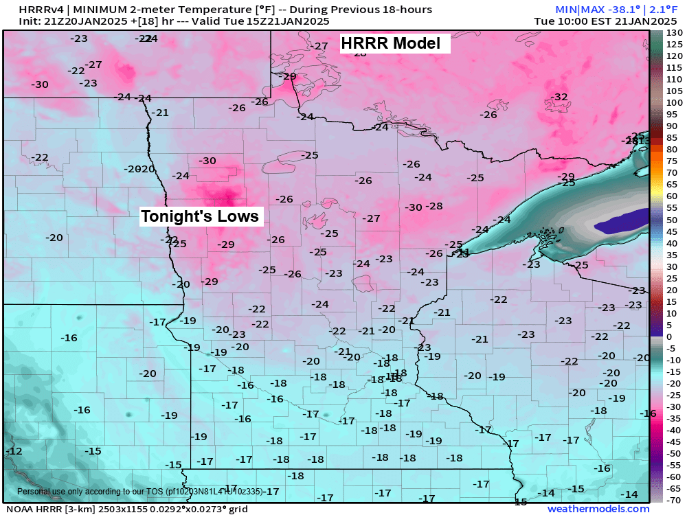
Lows tonight will range from around 15 below to 30 below zero, with temperatures as cold as 35 below to 40 below possible in some locations in northern Minnesota.
Record Lows for January 21
- International Falls -46 set in 2011
- Brainerd -42 set in 1984
- Hibbing -35 set in 1954
- Duluth -33 set in 1883
- Ashland -28 set in 1926 and 1963
Temperatures are forecast to slowly rise Tuesday afternoon and should climb to around zero to 5 above as we get a little warm advection as winds shift to the south ahead of a clipper approaching from the northwest.
The period from midweek to this weekend will be characterized by up-and-down temperatures, with more subzero nights expected, but also some warmer temperatures during the day possibly reaching the teens and even into the 20s.
This is quite the arctic blast, with temperatures at 500 mb (~18,000 feet) dropping to around -45°C over much of northeast Minnesota and northwest Wisconsin this afternoon.

Temperatures at 850 mb (~5000 feet) were right around -32 to -33 °C in northeast Minnesota and northwest Wisconsin today, which is quite impressive.

Today’s Highs and departure from normal 1/20/2025
International Falls, MN: -18 (33 degrees below normal)
Hibbing, MN: -16 (33 degrees below normal)
Duluth, MN: -12 (32 degrees below normal)
Brainerd, MN: -12 (33 degrees below normal
Ashland, WI: -6 (28 degrees below normal)
Temperatures across the Northland this afternoon were running anywhere from -25 to -35 degrees below normal.

Even with a decent amount of sun today, temperatures have only managed to rise to around -7 to -18 degrees across the Northland this afternoon.

Wind chills remain dangerously cold this afternoon, ranging from the 20s below to the 40s below zero from North Dakota to northern Minnesota and into northern Wisconsin.

An extreme cold warning continues until noon Tuesday for all of northeast Minnesota and northwest Wisconsin due to continued dangerously cold wind chills.

Wind chills tonight into Tuesday morning will range from around 30 below to 50 below zero, with a few locations in northeast Minnesota possibly dropping as low as 55 below zero.
Will see some improvement in the wind chills Tuesday afternoon and evening, ranging from around 15 below to 25 below zero.
HRRR model wind chill forecast valid 7 PM this evening to 7 PM Tuesday.

Some snow Tuesday night
A clipper system will affect the Northland Tuesday night, bringing a shot of warm air advection along with some snow. There won’t be much moisture for this system to tap into, which is typical for clipper systems and Arctic air masses, but there should be enough lift and just enough moisture to still produce a little snow in northeast Minnesota and northwest Wisconsin Tuesday evening into early Wednesday morning.

For Duluth: Some snow is expected Tuesday night, beginning after 6 PM and ending early Wednesday morning. An inch or less of accumulation is anticipated.
NAM 3km model simulated radar forecast valid 6 PM Tuesday to 6 AM Wednesday.


Subscribe to continue reading
Become a paid subscriber to get access to the rest of this post and other exclusive content.