5:32 PM Sunday, January 19, 2025
Sunday morning low temperatures (1/19/2025)
International Falls, MN: -24
Hibbing, MN: -23
Duluth, MN: -22
Brainerd, MN: -19
Ashland, WI: -16
*Duluth’s low of -22 this morning was the first time since February 3, 2023, that the temperature dropped to -20 or colder.
Minimum Wind Chill Reports from Sunday, January 19, 2025
Grand Marais, MN: -53
Duluth, MN: -48
Hibbing, MN: -46
Isabella, MN: -45
Duluth Airport: -45
Orr, MN: -45
Silver Bay, MN: -44
Hermantown, MN: -42
Grand Rapids, MN: -42
Ely, MN: -42
Cloquet, MN: -40
Duluth Sky Harbor Airport: -40
Cable, WI: -39
South Range, WI: -38
Brainerd, MN: -36
Spooner, WI: -36
Siren, WI: -36
Hinckley, MN: -33
*Bitterly cold temperatures and dangerously cold wind chills will continue for the next few days.
*Lows tonight and Monday night will range from around -15 to -30 degrees, with temperatures as low as -35 degrees possible in the typical cold spots in northern Minnesota, especially on Monday night.
*Highs Monday will range from -5 to -15 degrees, with highs Tuesday ranging from -5 to 5 above zero, and the warmest temperatures will not arrive until Tuesday evening.
*Dangerously cold wind chills will also continue through early Tuesday afternoon, with an extreme cold warning in effect for all of northeast Minnesota and northwest Wisconsin.
*Wind chills will range from around 20 below to 35 below zero on Monday afternoon, and from around 25 below to 50 below zero tonight and Monday night/Tuesday morning.

HRRR model wind chill forecast through 12 PM Tuesday.

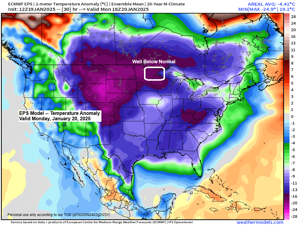
This is a widespread shot of Arctic air stretching all the way from central Canada to the southern Plains today.
850 mb temperatures have fallen to around -30°C in the Northland today, and those temperatures will drop a little more, peaking around -31°C to -35°C on Monday.
500 mb heights in the Northland have dropped to around 505 decameters in this Arctic airmass today, which is around -2.5 standard deviations below normal, while thickness values drop to as low as 480 meters on Monday. This is all indicative of a potent Arctic airmass.
There’s also been an increasing amount of haze in the Northland skies today, which is also a sign of a classic Arctic airmass.

Widespread winter weather alerts are in effect across various parts of the U.S.


This arctic air mass covering central Canada, northern Plains, and the upper Midwest was actually visible on satellite imagery today, with all of those green and blue colors from central Canada south to Minnesota indicating the arctic air and not really a whole lot of clouds, with temperatures as low as around -25 to -40°C.
Goes-16 infrared satellite loop from Sunday.
Deep south snow and ice
Accumulating snow and some ice are forecast to impact much of the Deep South and Southeast U.S. Tuesday into Wednesday, with various winter storm warnings, watches, and advisories in effect, including a winter storm warning for Houston and New Orleans, and a winter storm watch for much of North Florida.

European model total snowfall for Tuesday through early Wednesday morning.

A few snow chances are ahead mid to late week…

Subscribe to continue reading
Become a paid subscriber to get access to the rest of this post and other exclusive content.