5:05 PM Sunday, March 2, 2025
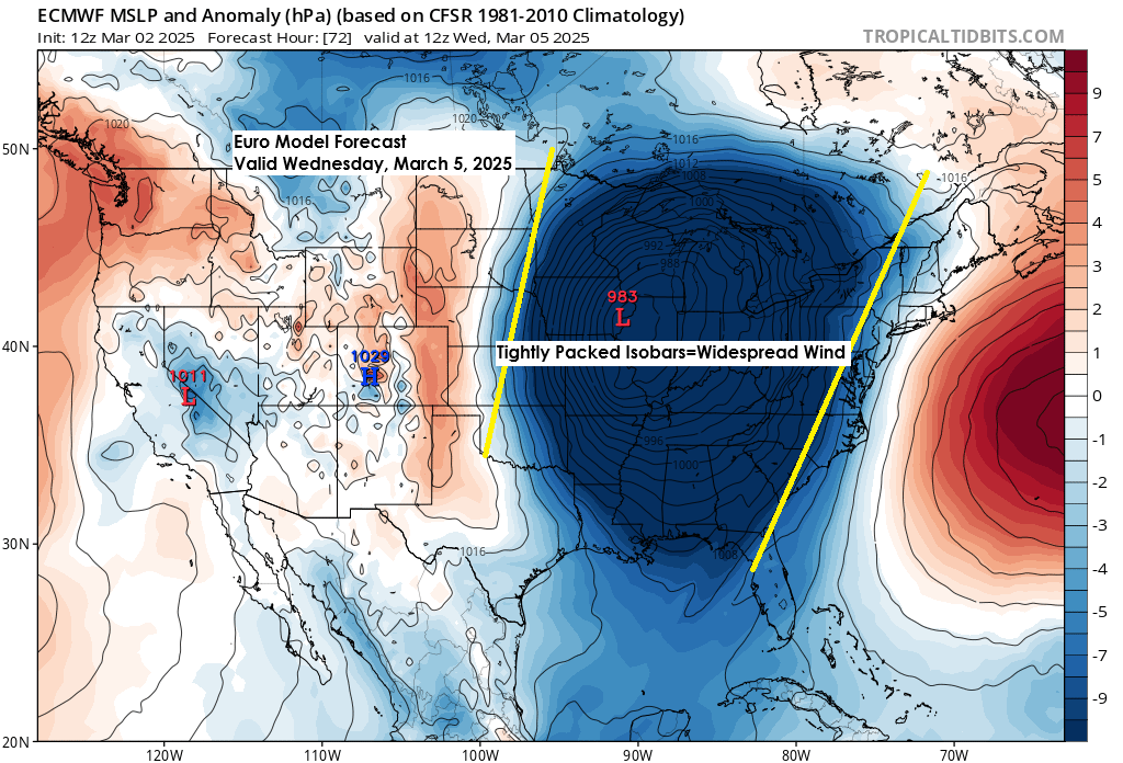
A strong spring storm will track northeast from the central Plains to the Midwest to the eastern Great Lakes through midweek. This system will produce widespread windy weather over a large portion of the central and eastern U.S. as we get to Tuesday and Wednesday due to a deep surface low < 985 mb.
Northland area
- Some light rain is possible beginning Monday evening and continuing into Tuesday. Some patchy freezing rain is also a possibility, mainly in northeast Minnesota, but no major ice accumulation is expected the way things look now.
- Colder air, both aloft and at the surface, spreads southeast out of northern Minnesota Tuesday, causing any rain or mixed precipitation to switch over to snow late Tuesday afternoon or Tuesday night.
- Some snow continues Wednesday but is forecast to diminish from west to east by Wednesday afternoon.
- Gusty north winds will develop Tuesday night into Wednesday with gusts ranging from 20 to around 40 mph.
Storm Track
There hasn’t been much change in the ensemble models regarding the storm track for this week. It still looks like we will see an area of low pressure somewhere between northwest Oklahoma and north central Kansas Tuesday morning, tracking northeast toward the Chicago, IL area around mid-morning on Wednesday, with this low then reaching Lake Huron Wednesday evening.
No major shifts in the storm track either north or south have occurred yet in the computer models, but some changes may still occur over the next 24 hours.
This storm track is too far south for a major snow event in Duluth midweek, but light snow accumulation may still occur.

Euro model simulated radar forecast valid 7 PM Monday to 7 PM Wednesday.
Rain (green)
Snow (blue)
Pink (wintry mix)

Snowfall Forecast
Changes to my snowfall forecast are still possible since we are about 2 days away from this system, so check back for updates.

Wind
Purple areas on the loop below show wind gusts of at least 30 mph, while red and yellow areas indicate gusts from 40 to 55 mph or higher.
Euro model wind gust forecast valid 6 AM Tuesday to 6 AM Thursday.

For the Northland, the strongest winds are expected from Tuesday evening through Wednesday, with north winds gusting from 20 to around 40 mph.
Euro model wind gust forecast valid 12 PM Tuesday to 6 PM Wednesday.

Euro ensemble model 500 mb forecast valid 6 AM Monday to 6 PM Wednesday, showing the progression of a strong trough (blue and green colors on the loop) tracking northeast out of the southern Rockies, reaching the Great Lakes and Ohio Valley by midweek.

Severe Thunderstorm Potential

Severe thunderstorms are possible through midweek.
Today’s risk covers a small area in north Texas and southwest Oklahoma.
Hazards through Tuesday include strong winds, large hail, and a chance of tornadoes.

Severe thunderstorms are expected to cover a wider area from the central to southern Plains on Monday.

As Tuesday approaches, the chance of severe thunderstorms moves south and east.

Make a one-time donation
Make a monthly donation
Make a yearly donation
Choose an amount
Or enter a custom amount
Your contribution is appreciated.
Your contribution is appreciated.
Your contribution is appreciated.
Disturbance over the southern Plains today.
Radar loop ends 4:50 PM CT Sunday, March 2, 2025.
Goes-16 satellite loop ends 4:30 PM CT Sunday, March 2, 2025.
Severe Thunderstorm Warning – Yellow
Tornado Warning – Red
System impacting the west coast today.
Radar loop ends 4:52 PM CT Sunday, March 2, 2025
Goes-16 water vapor loop ends 4:46 PM CT Sunday, March 2, 2025
Thanks for reading!
Leave a Reply