5:40 PM Saturday, March 1, 2025
A strong low-pressure system is forecast to develop across the southern/central Plains early next week.
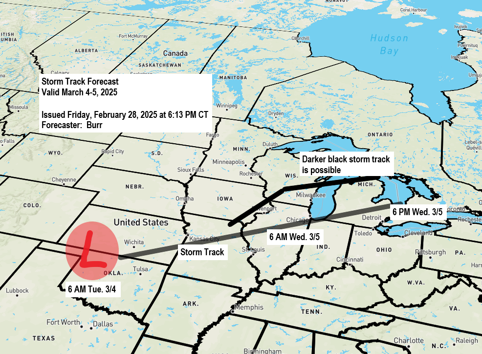
-This low is forecast to track northeast out of western/southern Kansas Tuesday morning toward the Chicago, IL area around dawn on Wednesday, reaching Lake Huron Wednesday evening.
-This system could bring some precipitation to northeast Minnesota and northwest Wisconsin beginning either Monday night or during the day Tuesday continuing into Tuesday night and Wednesday.
-Initially, sufficient warm air will likely cause precipitation to begin as rain or some patchy freezing rain Monday night or Tuesday. However, as the column cools, the rain will transition to snow from west to east in the Northland by Tuesday afternoon and night.
-Precipitation amounts (rain, snow, ice) remain uncertain since this system is still a few days out and will also depend on the storm track. If the system tracks farther north, the potential for heavier precipitation amounts would increase in parts of northwest Wisconsin and east central Minnesota, whereas if the storm shifts farther south, lesser amounts of precipitation would occur. Both scenarios are a possibility right now.
-Wind could also be an issue as we get into Tuesday night and Wednesday as north winds increase with gusts possibly exceeding 25 to 30 mph in parts of the Northland. If snow occurs, the wind combined with the falling snow could lead to areas of blowing snow.
Duluth area: At the moment, this storm looks to be tracking too far south to give us anything more than some light snow potential Tuesday evening into Wednesday. I have concerns about the thunderstorm potential farther south robbing some moisture from getting up this way. Plus, if we see widespread convection to the south, this could force the storm track to shift even farther south. Also, winds look to have more of a northerly component, which isn’t usually a favorable wind direction to get a lot of snow in Duluth; winds out of the east to northeast are typically much more favorable for getting heavier snow in Duluth. Additionally, this just hasn’t been the winter to get hit by a big storm coming out of the Rockies, as every system that has come out of that area in the last few months has taken a similar path through parts of the central Plains and Midwest, so I have my doubts this system will buck that trend.
As of late Saturday afternoon, this is where I think the highest chances are for getting 4 or more inches of snow in the middle of next week.
This forecast will likely change in the next few days so be sure to check back.

Make a one-time donation
Make a monthly donation
Make a yearly donation
Choose an amount
Or enter a custom amount
Your contribution is appreciated.
Your contribution is appreciated.
Your contribution is appreciated.
Euro model 850mb temperature forecast valid 6 AM Tuesday to 6 PM Wednesday.
Once temperatures at 850mb fall below 0°C, we will see any rain or mixed precipitation shift over to snow, and that looks to occur from west to east in the Northland Tuesday afternoon or evening.

Euro model wind gust forecast valid 12 PM Tuesday to 6 PM Wednesday.

Thanks for reading!
Leave a Reply