7:16 PM Sunday, March 9, 2025
Record warmth in Duluth today and will likely be setting new record high temperatures not only in Duluth but also in other cities across the Northland on Monday.
Duluth’s high today of 57 degrees, breaks the March 9th record of 55 degrees set in 2021.
Duluth recorded its first official 50 of the year today (March 9th). The average date for the first 50 is March 20th. Last year, Duluth recorded its first 50 on February 5th.
If Duluth reaches 60 degrees on Monday, it will be about a month earlier than usual, as we typically see the first 60 degree day around April 11th. Last year’s first 60 degree day was on March 11th.
The setup on Monday involves a strong area of low-pressure between 986-991mb moving east across Ontario, placing the Northland in its warm sector. Gusty southwest winds will bring warmer air, raising 850mb temperatures to +6 to +11°C in the Northland. With good mixing, we can expect temperatures in the 60s in east central Minnesota and northwest Wisconsin, and 40s and 50s in northern Minnesota and Arrowhead.
Some areas in east central Minnesota may even reach 70 degrees Monday afternoon, but the chances are low.
Record Highs for Monday (March 10th)
Hibbing, MN: 62 set in 2012
Ashland, WI: 61 set in 2015
International Falls, MN: 59 set in 2012
Duluth, MN: 58 set in 2015
Brainerd, MN: 58 set in 2012

It will be windy on Monday, with southwest winds during the day gusting 15 to 35 mph. Winds will switch to the northwest at night, with possible gusts of 35 to 45 mph.
HRRR model wind gust forecast valid 7 AM Monday to 7 AM Tuesday.

Much colder air will arrive Monday night, dropping temperatures to the single digits and teens by Tuesday morning, with subzero temperatures possible in far northern Minnesota near the Ontario border.

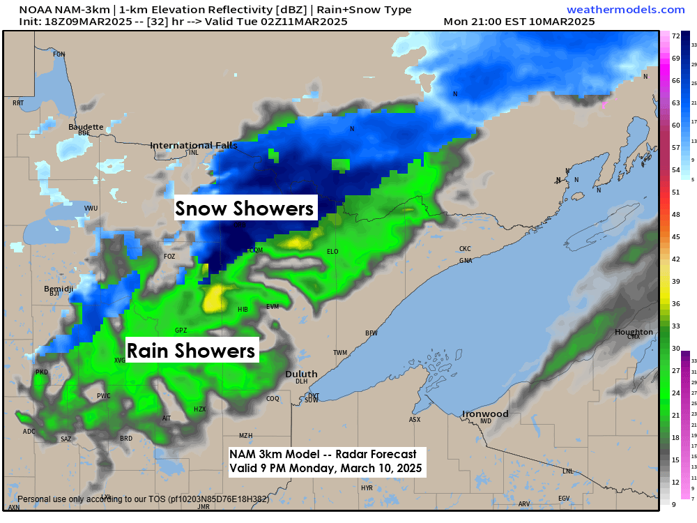
A strong cold front will cross the Northland from northwest to southeast later Monday afternoon and evening, with a brief burst of snow and rain showers occurring in parts of the area.
NAM 3km model simulated radar forecast valid 7 PM Monday to 1 AM Tuesday.

Make a one-time donation
Make a monthly donation
Make a yearly donation
Choose an amount
Or enter a custom amount
Your contribution is appreciated.
Your contribution is appreciated.
Your contribution is appreciated.
Strong System Later This Week
Still looking at a strong spring storm emerging from the Rockies later this week, with a deep low-pressure system between 972 and 980 mb.
The track of this low is still a bit uncertain, with some computer models continuing with a more westerly storm track, while a few others show the system on a more easterly track.
Regardless of the storm’s path, it seems that much of the Northland will see rain on Friday and Saturday. However, if the storm shifts east, colder air may arrive earlier, leading to a change from rain to snow or a wintry mix in some areas Saturday afternoon. Otherwise, snow is likely to begin Saturday night before the storm completely moves out by Sunday.
Other impacts from this storm would be from the wind especially next weekend.
Snowfall accumulations in our area remain very uncertain at the moment, but the greatest chances for snow accumulations of 3 to 6 inches or more include areas farther west of the Northland; although that area could shift a bit more to the east in the coming days should the storm track shift a bit.
Stay tuned for updates.

This storm should have a good feed of rich gulf moisture pumping north into the upper Midwest with precipitable water > 0.50 to 0.75 inches.

Ahead of this system on Friday, dew points could climb into the 40s and 50s in much of Minnesota and Wisconsin, with the higher dew points likely in the southern parts of both states.

Higher amounts of instability (CAPE) are still showing up on the computer models for Friday, which could lead to some thunderstorm activity in parts of the upper Midwest, including for us in the Northland.
It’s still too early to tell if any of these storms will become severe, but I definitely can’t rule out that possibility, especially over southeast Minnesota and southern Wisconsin from Friday evening to early Saturday morning.

Here’s the severe thunderstorm outlook for Friday, March 14, 2025.
The area outlined in yellow represents where we could see severe thunderstorms on Friday with all hazards possible, including large hail, damaging winds, and a few tornadoes. This risk area may shift a little farther north in the coming days.

Thanks for reading!
Leave a Reply