6:05 PM Thursday, March 13, 2025
-A strong storm will affect the Northland on Friday and Saturday, but it likely won’t have a big impact in most of our area, as the low-pressure center is expected to pass right through the Northland on Saturday.
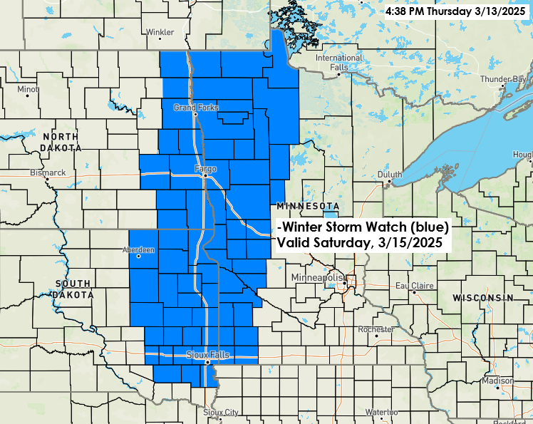
-Far greater impacts are expected with this storm in the eastern Dakotas and western/northwestern Minnesota, where we could see some ice accumulation early Saturday morning followed by strong winds, falling temperatures, and snow, with possible blizzard conditions developing on Saturday.
-And then, in the warmer air, we could see a potential severe weather outbreak on Friday over the Lower/Mid-Missouri/Mississippi Valleys and Lower Ohio Valley, and on Saturday, a severe weather outbreak is possible over the central Gulf Coast States and Deep South into the Tennessee Valley.
For the Duluth area
-Scattered showers Friday and Saturday with some patchy drizzle and fog also possible.
-Isolated thunderstorms are possible Friday and Friday night, but severe weather is not expected.
-Temperatures drop late Saturday afternoon changing any rain over to some snow but by the time the cold air arrives much of the moisture will have pushed away which means little to no snow accumulation in Duluth Saturday evening.
-Temperatures in the lower 40s Saturday afternoon are forecast to drop to the upper 20s around 7 PM Saturday and into the teens by Sunday morning.
-Winds will be out of the east with gusts of 15 to 25 mph Friday into Saturday morning. Winds shift to the northwest with gusts of 20 to 35 mph Saturday evening into Sunday morning.
Total Precipitation
Much of northeast Minnesota and northwest Wisconsin can expect at least a quarter inch of precipitation by Saturday evening, with higher totals of 0.50 to upwards of 0.75 inches possible, especially over the northwestern portions of the area.

Here’s my snowfall forecast for Saturday.
Most of the accumulating snow is forecast to be over the northwest portions of the area, with the changeover from rain to snow expected to occur sometime between mid-morning Saturday and early afternoon on Saturday.

Precipitation Type
Here’s the European model precipitation type forecast at the times listed on the maps below.


European model simulated radar forecast valid 7 AM Friday to 1 AM Sunday.
Rain – Green
Snow – Blue
Wintry Mix – Pink & Orange
Note: If we were to see some flakes in Duluth, it likely wouldn’t be until Saturday evening; anything that falls before then will be rain.

Severe Thunderstorm Chances

Friday’s outlook
Note: A marginal risk for severe thunderstorms extends north into east-central Minnesota and northwest Wisconsin Friday and Friday night, with a higher chance for severe thunderstorms farther south. Hail and gusty winds would be the main hazards if thunderstorms occur in parts of the Northland on Friday.

Tornado outlook for Friday, March 14, 2025.

Saturday’s Outlook

Lots of wind with this storm
Wind alerts in brown

Fire weather concerns in the pink areas on the map below.

Here comes the storm which will bring widespread severe weather, wind, fire weather concerns, and some snow in the next few days. The system of interest continues to move across the southwest/western US today.
Goes-16 infrared satellite loop ending 5:25 PM CT Thursday, March 13, 2025.

Here’s the storm track forecast through Saturday evening.
There’s still some uncertainty about the path of the low once it reaches the upper Midwest on Saturday morning, but these differences won’t mean much in most of the Northland.

Thanks for reading!
Leave a Reply