6:10 PM Tuesday, March 11, 2025
An update on the messy spring storm which is forecast to affect the Northland on Saturday.
For the Duluth area
High Confidence in the following
- Rain
- Gusty Winds
- Much colder temperatures late Saturday into Sunday
Lower Confidence in the following
- Whether or not we see any wintry precipitation, and if we do how much
- Thunderstorms
- Timing of the colder air
Before I dive into the system for Saturday, I do have to mention the disturbance moving east out of North Dakota today, which will likely produce a little snow across northern Minnesota, the North Shore, and Arrowhead areas later tonight, with this snow ending by early to mid-morning on Wednesday. An inch or less of snow is possible with this system.
Duluth appears to be on the southern fringe of this snow late tonight, so we could see very little to no snow, or perhaps up to a half inch of snow early Wednesday morning.
Euro model simulated radar forecast through Noon Wednesday.

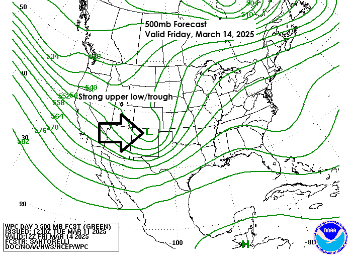
Now onto the mess for Saturday
Snowfall Potential
Based on the storm track, timing of the cold air, and where the moisture overlaps the cold air, areas in north-central Minnesota currently have the greatest chance of getting 1 to 3 inches or more of snow on Saturday. This area may shift slightly more to the east or west in the coming days. Stay tuned.

Freezing Rain/Ice Potential
There continues to be a chance for some freezing rain and ice accumulations on Saturday over about the western half of Minnesota, which includes north-central areas of Minnesota, with the greatest chances for getting some ice accumulation west of that black line on the map.

Euro ensemble model probability for >0.1″ ice accumulation for the 24-hour period ending 7 PM Saturday.

Liquid equivalent precipitation totals of around a half an inch to an inch are possible in much of the Northland Friday night into Saturday.
NWS Blend of Models total precipitation (Rain + Snow) through 7 AM Sunday.

Colder temperatures appear to be a bit slower to arrive in the Northland on Saturday, with temperatures not forecast to fall below freezing until late Saturday morning or early Saturday afternoon in western parts of the Northland. This cold air will continue to move east, with temperatures forecast to fall below freezing in Duluth Saturday evening after 6 PM, the way it looks now.
By Sunday morning, temperatures are expected to be in the teens to about 20 degrees across the Northland.
Euro model temperature forecast valid 7 AM Saturday to 1 AM Sunday.

Strong Winds This Weekend
North/west winds are forecasted for the Northland on Saturday and Sunday, with gusts reaching 25 to 35 mph, possibly up to 45 mph. The stronger winds will spread east across the Northland later on Saturday.
Note: It doesn’t look like we’ll have an easterly gale on western Lake Superior from this storm, but gusts from the east of 15 to 30 mph may occur Friday night and Saturday morning.
Euro model wind gust forecast from 7 AM Saturday to 7 PM Sunday.

On Friday, temperatures in Minnesota and Wisconsin will mostly be in the 50s and 60s, with some areas in the south reaching the 70s.
East winds will keep temperatures cooler and in the 30s and 40s within about 10 to 15 miles of Lake Superior on Friday.

Higher amounts of instability (CAPE), along with steep mid-level lapse rates, are forecast to lift northeast into the Northland Thursday night and linger into early Saturday morning, and this could lead to some thunderstorm activity at times. Severe weather is not expected this far north, but brief downpours, small hail, and lightning are possible if thunderstorms develop.
European model CAPE forecast valid 7 PM Thursday to 7 AM Saturday.

Severe Thunderstorm Potential
Severe thunderstorms with large hail, strong winds, and possible tornadoes may occur on Friday and Saturday.
The risk for a few severe thunderstorms on Friday reaches as far north as southeastern Minnesota and southern Wisconsin.
Friday’s Outlook

Saturday’s Outlook

Thanks for reading!
Leave a Reply