4:17 PM Saturday, March 15, 2025
A strong low-pressure system brought a variety of weather conditions to the Northland today.
In the warmer air to the east, we saw an area of scattered showers and thunderstorms move east across parts of northwest Wisconsin today.
To the west, it’s been a snowy and windy day.
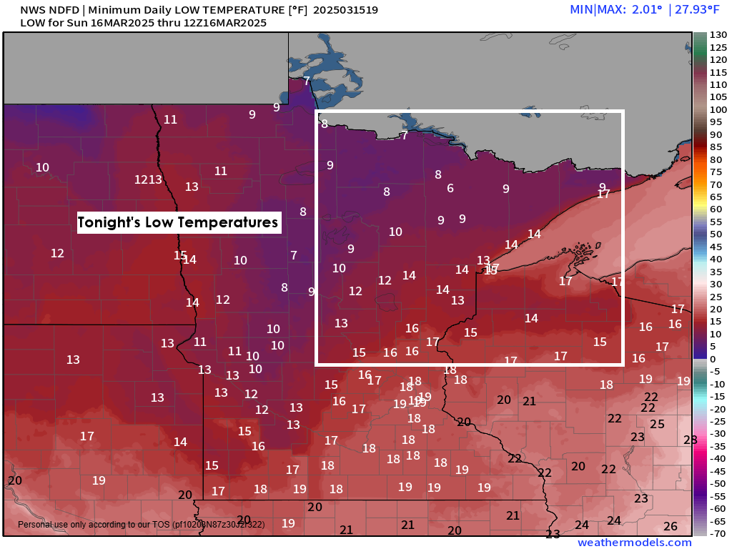
Also, of note has been the rapidly falling temperatures in the wake of this storm, as temperatures have dropped to the teens and 20s this afternoon in much of north-central Minnesota.
Temperatures in Duluth were in the low to mid 40s earlier this morning but have fallen to the upper 20s to lower 30s as of 2 PM this afternoon, and these temperatures will continue to drop, likely ending up in the middle teens by Sunday morning while single digit temperatures are likely across northern Minnesota.
Wind will remain an issue across the Northland tonight and Sunday morning in the wake of this storm, with northwesterly winds gusting 15 to 30 mph and gusts as high as 45 mph possible tonight.

Deep low pressure of 981 mb or 28.97 inches was located near Thunder Bay, Ontario, Canada, as of 3 PM today; this low will continue to lift farther away as it tracks northeast.

One of the warmer days in the upcoming week looks to be on Monday, with highs in the 40s and 50s in east-central Minnesota and northwest Wisconsin, and 30s and 40s in far northern Minnesota, where we could see a little snow on Monday.
Even warmer temperatures are expected Monday across southern Minnesota, with temperatures in the 60s.

Here’s a look at some satellite loops of this powerful spring storm lifting north across the upper Midwest into central Canada today.
Goes-16 water vapor loop from Saturday, March 15, 2025.

Infrared satellite loop from Saturday, March 15, 2025.
A severe weather outbreak occurred Friday afternoon and Friday night to the south, with over 500 preliminary storm reports including nearly 30 tornado reports.
Tornadoes were seen in Missouri, Arkansas, Mississippi, Illinois, and Indiana on Friday.

Another severe weather outbreak is occurring today and will continue into tonight over parts of the Southeast U.S. with two PDS (Particularly Dangerous Situation) tornado watches, and one tornado watch in effect.
Additional watches will likely be issued to the east of the current watches through tonight.

The ingredients in place to support today’s severe weather outbreak include very strong jet stream winds and divergence coupled with warm and humid air. Instability, or the amount of fuel and energy, is on the high side today with strong wind shear in place, both directional shear (winds changing with height) as well as speed shear (increasing winds with height).


We have very high values showing up this afternoon in the violent tornado parameter centered on central and eastern Mississippi into west-central Alabama.

Radar loop ends 3:40 PM CT Saturday, March 15, 2025.
In addition to the severe weather threat, there are widespread flash flood warnings in effect this afternoon in parts of the southeastern U.S., with radar estimating between 2 and 4 inches of rain in some areas through 2 PM today.

Thanks for reading!
Leave a Reply