6:20 PM Friday, March 14, 2025
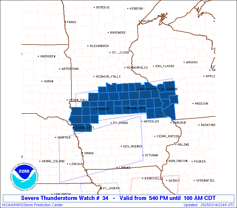
We had one round of scattered thunderstorms move across parts of the Northland earlier today, and now the next round of storms is lifting north out of Iowa late this afternoon, and some of these storms could become severe tonight in southern Minnesota and far southwestern Wisconsin, where a Severe Thunderstorm Watch (blue area on the map) is in effect until 1 AM. Hail up to 2 inches in diameter and winds up to 70 mph are the primary severe weather threats.
Some of us in northwest Wisconsin and northeast Minnesota saw our first thunderstorms of the year this morning, including in West Duluth between 7 and 8 AM.
There were reports of mostly sub-severe hailstones with some of the storms in the Northland this morning, see below.
- 9:37 AM: Hail 0.70 inch. 4 ENE Cornucopia, WI (Bayfield County)
- 9:20 AM: Hail 0.50 inch. 3 SW Little Marais, MN (Lake County)
- 9:14 AM: Hail 1.00 inch — Quarter size. Washburn, WI (Bayfield County)
- 8:44 AM: Hail 1.00 inch — Quarter size. 3 SW Ashland, WI (Bayfield County)
- 8:40 AM: Hail 1.00 inch — Quarter size. 4 WSW Washburn, WI (Bayfield County)
- 8:40 AM: Hail 0.75 inch. Washburn, WI (Bayfield County)
- 8:33 AM: Hail 1.00 inch — Quarter size. 3 NE Moquah, WI (Bayfield County)
- 8:25 AM: Hail 0.25 inch. 1 W Ashland, WI (Ashland County)
- 8:20 AM: Hail 0.25 inch. 3 S Ashland, WI (Ashland County)
- 8:13 AM: Hail 0.70 inch. 4 E Grand View, WI (Bayfield County)
- 8:10 AM: Hail 0.88 inch. Two Harbors, MN (Lake County)
- 8:07 AM: Hail 0.25 inch. 4 WNW Embarrass, MN (St. Louis County)
Record Warmth in the Northland today, Friday, March 14, 2025
Brainerd, MN
New record high: 66
Old record high 64 set in 2012
International Falls, MN
New record high: 61
Old record high 60 set in 2016
Although not a record for March 14th, the high of 57 in Duluth today (airport location) marks the 4th time this month with a temperature of at least 50 degrees. Duluth only averages 2 days in March with a temperature of 50 or warmer.
Thanks for reading!
Leave a Reply