6:25 PM Monday, March 17, 2025
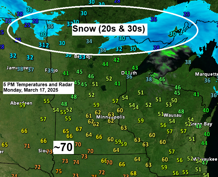
It’s been your typical March day in Minnesota, where we have several inches of snow with temperatures in the 20s and 30s in one part of the state, while another part of the state has temperatures in the 60s to around 70 degrees.
Far northern Minnesota has had quite a snowy Monday thanks to a low-pressure system that tracked across central Minnesota today.
Snowfall Reports as of Monday afternoon (March 17, 2025)
1 SSW Kabetogama, MN: 8.0″
International Falls, MN: 5.6″
Note: A new record for daily snowfall was set at International Falls on March 17th with 5.6 inches, breaking the old record of 2.9 inches from 1994.
A large temperature gradient was in place with this system today, with cold air to the north and warm air to the south, and there was plenty of lift occurring in the colder air today, which led to a west-to-east band of snow in northern Minnesota that was moderate to heavy at times, especially near the Ontario border.
Radar loop ends 5:06 PM CT Monday, March 17, 2025.
Strong Winter Storm Wednesday
Low pressure is forecast to move east-northeast out of west-central Kansas on Tuesday; this low moves over northern Illinois, near the Chicago area, by late Wednesday afternoon. Note: This storm track is too far south to bring much, if any, snow to Duluth Tuesday night and Wednesday, but there may be some snow in parts of northwest Wisconsin since that area will be on the northern edge of the heavier snowfall.
This system is expected to bring a swath of heavy snow and strong winds in a southwest to northeast direction, impacting parts of northern Kansas, the eastern half of Nebraska, western and northern Iowa, southern Minnesota to central and northeast Wisconsin, and into upper Michigan.
The bulk of this snow looks to fall on Wednesday, tapering off from southwest to northeast Wednesday night.
In addition to the falling snow, winds will be increasing out of the north, with high winds leading to potential blizzard to near-blizzard conditions on Wednesday.
The area outlined in blue on the map below represents a winter storm watch with a potential for 4 to 6 inches or more of snow combined with blowing snow.

Will see quite a temperature contrast set up over a short distance on Wednesday, with 850mb temperatures of around +6°C in southern Wisconsin to around -6°C in southern Minnesota, and this temperature variation will feed into this developing midweek winter storm.

Here’s my snowfall forecast for Wednesday.
Again, most of the snow looks to stay south of our area, but the northern edge of this system could bring a few inches of snow to the southeastern portions of northwest Wisconsin, southeast of a Spooner to Hayward line.
Duluth area: There may be a few flurries or snow showers from Tuesday afternoon to Wednesday morning, but no significant accumulation is expected. It will be on the breezy side Tuesday afternoon into Wednesday with wind gusts of 25 to 30 mph out of the northeast, then shifting to the north during the day Wednesday.

European model simulated radar forecast valid 7 PM Tuesday to 11 PM Wednesday.
Snow – Blue
Rain – Green
Wintry Mix – Pink

Thanks for reading!
Leave a Reply