1:51 PM Monday, March 24, 2025
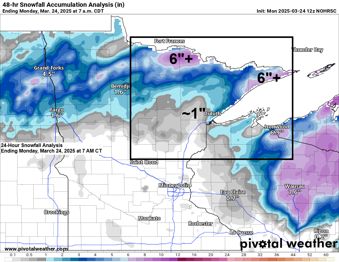
-The biggest snowfall winners on Sunday were in far northern Minnesota, especially around International Falls and in the Arrowhead near Grand Marais, with reports of 6 to 10 inches of snow.
-For the International Falls area, this is the second significant snow event in the last week. On March 17th, 7.4 inches of snow fell, and on March 23rd, about 9 inches were recorded.
-Snow reports of 4 to 5 inches were recorded from Finland to Silver Bay on Sunday.
-Snowfall totals in the Ely area varied considerably on Sunday and ranged from 2 to 7 inches.
Note: Duluth has received 44.8 inches of snow in the 2024-2025 season (since Oct. 1st), which is 32.8 inches below normal to date. We have experienced only 58% of our typical snowfall by March 23rd.
Duluth has had 2.51 inches of precipitation since January 1st, which is 0.47 inches less than normal, so we’re actually not doing too bad in the precipitation department so far this year.
Snowfall Reports for March 23-24, 2025
- Hovland, MN: 10.7″
- 5 SSW International Falls, MN: 10.4″
- 3 NW Hovland, MN: 9.8″
- 4 NNE Grand Marais, MN: 9.5″
- 1 NW International Falls, MN: 9.0″
- 1 NW Kabetogama, MN: 9.0″
- 4 W Grand Marais, MN: 7.5″
- 6 NNW Ely, MN: 7.3″
- 3 ESE Bena, MN: 6.5″
- 3 WSW Lutsen, MN: 6.4″
- Federal Dam, MN: 5.6″
- 9 ESE Sea Gull Lake, MN: 5.5″
- 3 E Orr, MN: 5.1″
- 1 NW Hurley, WI: 5.0″
- 3 SE Finland, MN: 5.0″
- 1 W Silver Bay, MN: 4.3″
- 3 NW Ely, MN: 4.3″
- 8 ESE Northome, MN: 4.3″
- 4 WNW Red Cliff, WI: 4.3″
- Cook, MN: 4.0″
- 4 S Tower, MN: 3.6″
- 3.7 W Deer River, MN: 3.1″
- 1 NNW Walker, MN: 3.0″
- 2 E Celina, MN: 3.0″
- 3 SE Ely, MN: 2.6″
- 6 NNW Knife River, MN: 2.5″
- 4 WNW Two Harbors, MN: 2.5″
- 5 N Two Harbors, MN: 2.5″
- 3 WNW Clam Lake, WI: 2.3″
- 1 SE Cornucopia, WI: 2.3″
- Lester Park, MN: 2.1″
- 1 ENE Hibbing, MN: 2.0″
- 3 SSW Wentworth, WI: 1.8″
- Embarrass, MN: 1.7″
- 1 ENE Maple, WI: 1.7″
- 1 E Lester Park, MN: 1.5″
- 1 W Solon Springs, WI: 1.5″
- Brule, WI: 1.5″
- 1 WNW Cass Lake, MN: 1.5″
- 1 E Odanah, WI: 1.3″
- 1 NW Island Lake, MN: 1.2″
- Coleraine, MN: 1.1″
- 2 ESE Duluth, MN: 1.0″
- 6 NE Hertel, WI: 1.0″
- 2 SW Bayfield, WI: 1.0″
- 8 ESE Brainerd, MN: 1.0″
- Spooner, WI: 1.0″
- Duluth, MN: 0.8″ (official total at the NWS)
Here’s a map showing snowfall reports from March 23rd to the early morning hours of March 24th.

Here’s my snowfall forecasts for Sunday’s system.
Initial forecast issued on Thursday, March 20th.

Update on Friday, March 21st.

Final update on March 22nd.

Duluth metro snowfall forecasts for Sunday’s system.
Initial forecast issued on March 21st.

Updated and final forecast issued on March 22nd.

In the end, the low on Sunday sort of broke off into two, with one low taking a track closest to the purple line on the map, while another piece of the low followed the red line on the map.

Thanks for reading!
Leave a Reply