6:46 PM Friday, March 28, 2025
Here’s the latest on the system which will impact parts of the Northland Saturday evening into Sunday.
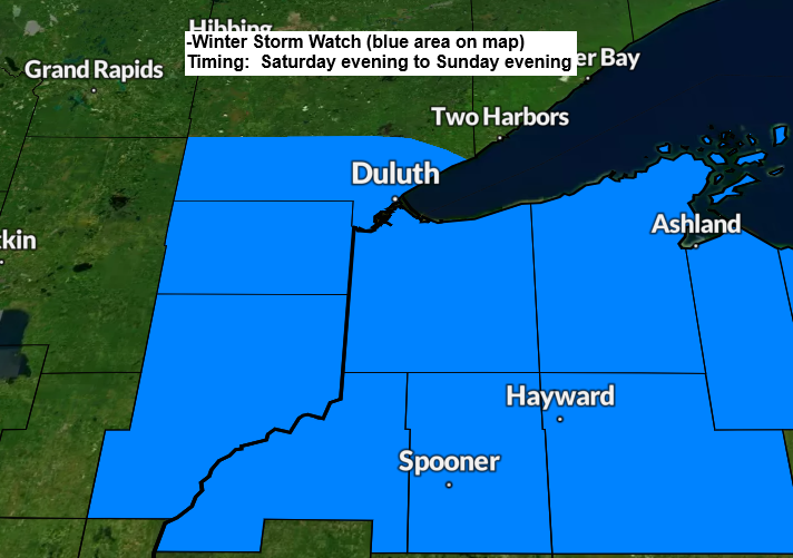
Winter Storm Watch has been issued for all of northwest Wisconsin and a part of eastern and northeast Minnesota from Saturday evening to Sunday evening.

There could be some patchy freezing drizzle or drizzle in Duluth during the day on Saturday, accompanied by a gusty wind from the northeast at 15 to 30 mph. However, a steadier precipitation is expected to arrive from the south late Saturday afternoon or Saturday evening, and this precipitation should persist into Sunday, diminishing around mid to late afternoon. The precipitation type in Duluth is expected to be mostly snow Saturday night and Sunday, although some sleet or freezing rain may occur on Saturday night, mainly before midnight. Wind will continue to an issue in Duluth Saturday night and Sunday with northeast winds gusting as high as 30 to 40 mph. Areas of blowing snow could develop Saturday night into Sunday.
NAM 3km model simulated radar forecast valid 1 PM Saturday to 7 PM Sunday.
Snow (blue)
Wintry Mix (purple/pink)

Here’s my snowfall accumulation forecast for Saturday night into Sunday.
-Totals could fluctuate, and the snowfall gradients depicted on the map may shift over the next 24 hours.
-This system will likely have a very sharp cutoff in snow amounts on the north and south side of this system.
Check back for updates
For Duluth: 3 to 5 inches of snow is possible between Saturday night and Sunday. As I noted above, these totals could increase or decrease over the next 24 hours.
Note: A few computer models indicate significantly higher snow totals in Duluth with this system. However, I am exercising caution with predictions as this is a complex system. Most of our snow events in the past few months have typically resulted in light to moderate accumulations, generally less than 5 inches.

A strong baroclinic zone (temperature contrast) will persist over the Upper Midwest on Saturday, with 850mb temperatures ranging from approximately 0°C near Duluth to around +10°C in southern Minnesota. Meanwhile, -10°C 850mb temperatures will be observed in central Canada.
Where the 850 mb temperatures are at or above 0°C, there will be a risk of more freezing rain with this second system Saturday night if surface temperatures are at or below freezing.
Currently, it appears that the greatest potential for freezing rain Saturday night will be situated to the south of Duluth and Superior.

Euro model total ice forecast through 7 AM Sunday.
Areas from east-central Minnesota into northwest Wisconsin have a chance for ice accumulations that could range from around 0.10 to over 0.25 inches Saturday night.
If ice accumulations reach or exceed a quarter of an inch, this could result in power outages and tree damage.

The setup on Saturday will feature an area of low pressure over Kansas, which is expected to lift to the north/east into eastern Iowa Sunday morning. Moisture surging north ahead of this low will interact with colder air coming south from Ontario to generate a wintry mix of snow, sleet, and freezing rain in northwest Wisconsin and in parts of northeast and east-central Minnesota from Saturday evening to Sunday.

Thanks for reading!
Leave a Reply