6:25 PM Saturday, March 29, 2025
Uncertainties in the Duluth forecast.
-Timing of when the precipitation begins tonight. As is often the case with systems approaching from the south, there’s always a battle between the strong NE wind off Lake Superior and the northeastward advancement of precipitation. Sometimes the computer models are too quick in bringing in the precipitation, but I do think we will see precipitation begin sometime before midnight, probably in the 8 to 10 PM time frame, however, if it ends up being later, then we will probably see less snow than what I’m forecasting.
-How much sleet or freezing rain occurs tonight. If we see more mixed precipitation that may keep snow totals down somewhat.
-An upgrade to a winter storm warning? I think those chances are relatively low due to actual snowfall amounts with this system, but the wind will be a factor as northeast winds will be gusting between 25 and 45 mph tonight and Sunday, so once the snow begins to fall and accumulate late tonight, we should see some blowing and drifting snow develop into Sunday.
Note: Snow should taper off in Duluth by mid to late afternoon on Sunday.
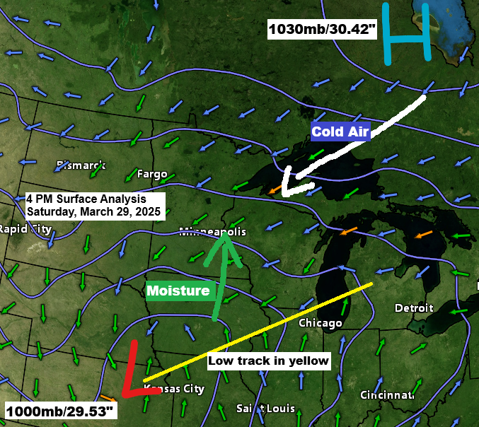
The weather setup shows high pressure over Ontario and low pressure in far northeast Kansas. This low will move east-northeast into southern/eastern Iowa by Sunday morning, continuing east-northeast through the day. A strong pressure difference between the high to the north and low to the south will create strong northeast winds near Lake Superior tonight and Sunday.
Updated Snowfall Forecast
Will likely see a very sharp gradient on the north and south sides of this system; on the north side, it’s due to the precipitation not advancing any farther north, while on the south side, it’s mainly due to a wintry mix of precipitation instead of all snow. Note: There is still uncertainty about just how far north the snow gets tonight as is often the case with these types of systems.

Expected snowfall totals in Duluth from late tonight into Sunday.

Precipitation will continue to slowly spread north/east into east-central and northeast Minnesota and northwest Wisconsin tonight. Precipitation tapers off from west to east Sunday afternoon/evening.
NAM 3km model simulated radar forecast through 11 PM Sunday night.
Snow (blue)
Wintry Mix (purple)

The highest chance for freezing rain and sleet tonight should be over eastern Minnesota into parts of northwest Wisconsin, where 850 mb temperatures are at or above 0°C.
Further to the north, including the South Shore and west to the Twin Ports, temperatures at 850 mb are cold enough to support mostly snow tonight, although precipitation could begin or mix with sleet/freezing rain at times.
Darker blue represents 850 mb temperatures below 0°C, while the light blue indicates 850 mb temperatures above 0°C late this afternoon.

Ice Accumulation Forecast
A swath of about 0.10 to 0.25 inches or more of ice accumulation is possible through Sunday morning from east-central Minnesota into northwest Wisconsin, south of Lake Superior.
Ice accumulations of a light glaze up to 0.05 inches are possible farther north to Moose Lake, Holyoke, Wrenshall, and Solon Springs.

Winter Weather Headlines
Various winter weather headlines are in effect across the region tonight and Sunday.


Radar loop ends 4:54 PM CT Saturday, March 29, 2025.
Goes-16 enhanced water vapor loop ending 4:51 PM CT Saturday, March 29, 2025.

Thanks for reading!
Leave a Reply