6:20 PM Thursday, April 17, 2025
Showers and thunderstorms moved northeast through parts of the Northland this afternoon. These storms developed along the leading edge of increased instability that advanced northeastward from southern Minnesota earlier today. This instability was primarily elevated, and in combination with a plume of very steep mid-level lapse rates, which peaked around 8 to 8.5°C/km, and an elevated mixed layer (EML) to the south, where temperatures in parts of the central Plains reached the 90s to around 100°F, these storms became efficient producers of lightning and hail. Most of the hail observed in our area was sub-severe, with diameters less than one inch.
Local Storm Reports for April 17, 2025
- 2:32 PM: Hail 0.50 inch. 3 E Hermantown, MN (St. Louis County)
- 1:35 PM: Hail 0.75 inch. Federal Dam, MN (Cass County)
- 1:24 PM: Hail 0.50 inch. 1 SSW Spooner, WI (Washburn County)
- 1:18 PM: Hail 0.50 inch. Spooner, WI (Washburn County)
- 1:15 PM: Hail 0.70 inch. Spooner, WI (Washburn County)
- 1:10 PM: Hail 0.88 inch. 3 W Shell Lake, WI (Washburn County)
- 1:00 PM: Hail 0.75 inch. 4 S Little Pine, MN (Crow Wing County)
- 12:47 PM: Hail 0.50 inch. 3 SW Swanburg, MN (Crow Wing County)
- 12:47 PM: Hail 1.25-inch (half dollar sized hail) 1 S Pequot Lakes, MN (Crow Wing County)
- 12:45 PM: Hail 1.00-inch (quarter sized hail) Grantsburg, WI (Burnett County)
- 12:40 PM: Hail 0.50 inch. 3 E Breezy Point, MN (Crow Wing County)
- 12:33 PM: Hail 1.00-inch (quarter sized hail) Pequot Lakes, MN (Crow Wing County)
- 12:20 PM: Hail 1.25-inch (half dollar sized hail) Pequot Lakes, MN (Crow Wing County)
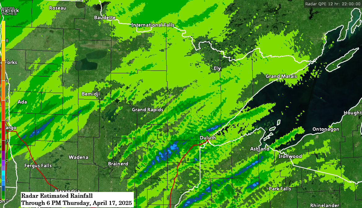
Rainfall Reports for April 17, 2025, as of 5 PM
Northome, MN: 0.37″
Webb Lake, WI: 0.31″
Odanah, WI: 0.3″
Clam Lake, WI: 0.24″
Siren, WI: 0.23″
Hayward, WI: 0.2″
Orr, MN: 0.19″
Superior, WI: 0.18″
Ashland, WI: 0.18″
Cass Lake, MN: 0.17″
International Falls, MN: 0.17″
Littlefork, MN: 0.15″
Eveleth-Virginia, MN: 0.15″
Spooner, WI: 0.14″
Saginaw, MN: 0.13″
Hermantown, MN: 0.13″
Duluth Airport: 0.12″
Bigfork, MN: 0.11″
Esko, MN: 0.1″
Winton, MN: 0.09″
Cook, MN: 0.08″
Danbury, WI: 0.07″
Winter, WI: 0.07″
Isabella, MN: 0.06″
Aurora, MN: 0.06″
Bay of Grand Marais, MN: 0.06″
Minong, WI: 0.05″
Glidden, WI: 0.05″
Hill City, MN: 0.05″
Poplar, WI: 0.05″
McGregor, MN: 0.04″
Schroeder, MN: 0.04″
Maple, WI: 0.04″
Ely, MN: 0.03″
Hibbing, MN: 0.02″
Cable, WI: 0.02″
Hinckley, MN: 0.01″
Rain showers continue to move north/east across parts of the Northland late this afternoon, and this rain will diminish from west to east later tonight. Isolated thunderstorms remain possible as well, although the amount of instability in our area has diminished significantly compared to earlier this afternoon.
Radar loop ends 5:52 PM CT Thursday, April 17, 2025.
Enhanced infrared satellite loop from Thursday, April 17, 2025, loop time ends 5:51 PM CT.

Additional rainfall amounts of approximately 0.1 to 0.3 inches are expected in northeast Minnesota and northwest Wisconsin tonight, with localized higher amounts reaching up to 0.5 to 0 .75 inches.

Thanks for reading!
Leave a Reply