6:27 PM Sunday, April 20, 2025
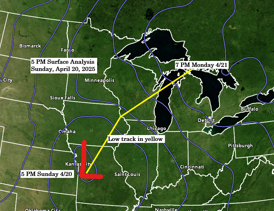
A low-pressure system over northern Missouri late this afternoon is expected to move northeast, reaching southern Wisconsin by 7 AM on Monday and far northern Lower Michigan by 7 PM on Monday. This system is projected to intensify, with its pressure dropping from approximately 1006 mb to around 1000 mb as it progresses into the Great Lakes region on Monday.
Northwest Wisconsin is expected to receive precipitation totals ranging from half an inch to over an inch by Monday afternoon, while northeast and eastern Minnesota including Duluth can anticipate amounts between a tenth and a quarter of an inch, with some localized higher totals possible in these regions.
There remains some uncertainty in the computer models regarding precipitation totals in northeast and eastern Minnesota including Duluth, with the possibility that the totals may be lower than forecasted.
Duluth area: Rain is anticipated to begin later tonight toward midnight, with precipitation expected to diminish by Monday afternoon. Should wet snow occur in Duluth, the most probable timeframe would be approximately between 5 AM and 10 AM on Monday

There is approximately a 6 to 8-hour window on Monday morning (around 3 AM to 10 AM) during which rain may transition to wet snow in parts of northeast Minnesota and far northern Wisconsin. This change could occur as heavier precipitation rates on the northwest side of the system result in sufficient dynamic cooling to facilitate the switch from rain to wet snow. However, surface temperatures will be marginal for snow, ranging between 33 and 35 degrees.
If heavier snowfall rates develop on Monday morning, it is possible to see anywhere from a trace to 2 inches of slushy accumulation before noon in some areas of northeast Minnesota and far northern Wisconsin. However, confidence is low regarding whether the rain will transition to snow, and if it does, how long the snowfall will linger before the system moves out on Monday afternoon.

HRRR model simulated radar forecast through 4 PM Monday.

A strong mid- and upper-level trough taking on a bit of a negative tilt will continue to progress northeast out of the northern and central Plains tonight, passing over the upper Midwest on Monday.

Here’s a look at the approaching system via water vapor imagery.
Goes-16 enhanced water vapor loop ends 6:11 PM CT Sunday, April 20, 2025.

Radar loop ends 6:08 PM CT Sunday, April 20, 2025.
Thanks for reading!
Leave a Reply