6:53 PM Saturday, April 26, 2025
A low-pressure system is expected to move northeast from South Dakota on Monday with its warm and cold fronts.
Tonight and Sunday, a flow of warm air and moisture will begin, leading to scattered rain in the Northland.
As instability rises Sunday night, thunderstorms are likely to develop, especially later in the night.
Monday is expected to be stormy with showers and thunderstorms moving through the Northland.
By early Tuesday morning, as the low-pressure system leaves, northern Minnesota and the Arrowhead may briefly see the rain change to wet snow but little to no snow accumulation is expected.
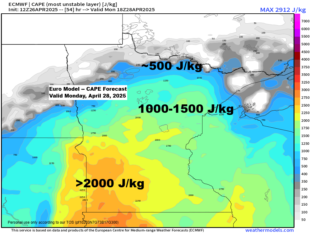
Scattered to numerous strong to severe thunderstorms are expected across the Northland on Monday, with an Enhanced risk (level 3/5) and a Slight risk (level 2/5) covering the entire region.
The main hazards in our area include large hail (quarter size or bigger), damaging winds over 60 mph, heavy rain, and frequent lightning.
The tornado threat here is low for Monday as storms will likely remain elevated in much of our area.


Widespread rainfall totals of a half inch to over an inch are likely in northeast Minnesota and northwest Wisconsin through early Tuesday morning, with most of this rain coming on Monday and Monday evening.

Temperatures on Monday will depend on cloud cover and the duration of showers and thunderstorms. If storms continue, the warm front may stay farther south in southern Minnesota, leading to cooler temperatures in northwest Wisconsin and east central Minnesota than the mid 60s and low 70s predicted by computer models.
Northern Minnesota will stay well north of this warm frontal boundary, with repeated rounds of showers and storms expected, with temperatures in the 50s to around 60.
A northeast wind off Lake Superior means it’ll be even cooler near Lake Superior and in Duluth on Monday, with temperatures in the 40s within about 15 miles of the lake.

An upper low with 500mb heights near 548 meters over California today is expected to move northeast into the northern Plains and upper Midwest by Monday. As this system approaches, 500mb heights will decrease, and atmospheric forcing will intensify, resulting in the development of showers and thunderstorms across the region.

Goes-16 enhanced water vapor loop ending 6:26 PM CT Saturday, April 26, 2025.

Changes are underway today as a warm air and moisture advection pattern gets underway across the northern Plains, and this will spread east into the Northland later tonight and Sunday, resulting in more cloud cover and some scattered rain showers.
Goes-16 infrared satellite loop ending 6:06 PM Saturday, April 26, 2025.

There is little instability with this first round of rain, so we shouldn’t expect many thunderstorms in the Northland late tonight or Sunday morning, just mostly showers.
Radar loop ends 6:04 PM Saturday, April 26, 2025.
NAM 3km model simulated radar forecast through 7 PM Sunday.

Thanks for reading!
Leave a Reply