2:00 PM Friday, May 16, 2025
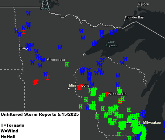
A line of strong to severe thunderstorms moved north over east central and northeast Minnesota and northwest Wisconsin from late Thursday afternoon to mid-evening.
These storms caused wind damage reports in northwest Wisconsin, along the North Shore of Lake Superior, and in Minnesota’s Arrowhead on Thursday evening.
On Thursday, there were about twelve tornado reports in Minnesota and Wisconsin, including 5 in Minnesota and 6 in Wisconsin.
Advertisements
Radar archives from Thursday.
Radar loop ends 4:03 PM Thursday, May 15, 2025.
Radar loop ends 7:49 PM Thursday, May 15, 2025.
Advertisements
Local Storm Reports from May 15, 2025
- 8:34 PM: Thunderstorm Wind Damage. 2 ENE Hovland, MN (Cook County) 2 big trees down. Wind gust of 74 mph.
- 8:15 PM: Thunderstorm Wind Damage. 9 ENE Grand Marais, MN (Cook County) Numerous spruce and poplar trees snapped along lake side of Highway 61.
- 7:40 PM: Thunderstorm Wind Damage. 5 SSE Sawbill Lake, MN (Cook County) Several medium trees (mixed types) down across The Grade.
- 7:40 PM: Thunderstorm Wind Damage. 6 S Sawbill Lake, MN (Cook County) Medium to large spruce tree partially blocking Sawbill Trail.
- 7:30 PM: Non-Thunderstorm Wind Gust 52 mph. 1 SSW Tofte, MN (Cook County)
- 7:21 PM: Thunderstorm Wind Damage. 1 ESE Aurora, MN (St. Louis County) 2 trees down on power lines.
- 7:20 PM: Thunderstorm Wind Damage. 2 ENE Tofte, MN (Cook County) Approximately 2/3 of the trees in Tofte Park were lost. Approximately 40 trees – 2 fell on the Tofte Town Hall.
- 7:19 PM: Thunderstorm Wind Damage. 6 NW Tower, MN (St. Louis County) 1 tree down on powerline, powerline down fully blocking the road.
- 7:05 PM: Thunderstorm Wind Gust 47 mph. 6 NE Little Marais, MN (Cook County)
- 6:45 PM: Thunderstorm Wind Damage. Silver Bay, MN (Lake County)
- 6:40 PM: Thunderstorm Wind Damage. 8 W Beaver Bay, MN (Lake County) Numerous spruce trees, approximately 10 to 15 feet, snapped near the base.
- 6:40 PM: Thunderstorm Wind Damage. 1 NE Beaver Bay, MN (Lake County) Trees down along and across Highway 61 between Ionas beach and East Beaver Bay. Also trees down in Silver Bay.
- 6:30 PM: Thunderstorm Wind Damage. 5 NE Castle Danger, MN (Lake County) Report of trees down around boat launch.
- 6:30 PM: Thunderstorm Wind Gust 47 mph. 5 NE Castle Danger, MN (Lake County)
- 6:10 PM: Thunderstorm Wind Damage. Marengo, WI (Ashland County) Top half of large spruce tree snapped and down onto the large branch of a nearby tree, all landing near a house.
- 5:45 PM: Non-Thunderstorm Wind Gust 57 mph. 3 S Chisholm, MN (St. Louis County)
- 5:44 PM: Hail 0.50 inch. Oslund, MN (Itasca County)
- 5:40 PM: Thunderstorm Wind Damage. 4 NW Namekagon, WI (Bayfield County) 2 balsam trees down.
- 5:40 PM: Thunderstorm Wind Damage. 1 SSW Lester Park, MN (St. Louis County)
- 5:38 PM: Thunderstorm Wind Gust 69 mph. 3 WNW Clam Lake, WI (Bayfield County) Wind measured 90 feet above ground and above the tree tops.
- 5:30 PM: Thunderstorm Wind Damage. 6 N Winter, WI (Sawyer County) Tree fell on cabin roof, twisting and breaking antenna.
- 5:30 PM: Thunderstorm Wind Damage. 7 S Loretta, WI (Sawyer County) One tree down, light outside furniture and tools tossed around. Wind shredded apart a tarp garage.
- 5:19 PM: Hail 0.50 inch. 1 SW Crosslake, MN (Crow Wing County)
- 5:05 PM: Thunderstorm Wind Damage. 2 W Radisson, WI (Sawyer County) 6 inch tree down over East bound lane of HWY 70.
- 4:55 PM: Thunderstorm Wind Damage. 1 NNW Trego, WI (Washburn County) A few trees knocked down.
- 4:50 PM: Thunderstorm Wind Damage. 5 SW Webb Lake, WI (Burnett County) Several branches 6 inch diameter broken off trees.
- 4:45 PM: Thunderstorm Wind Damage. 2 E Sarona, WI (Washburn County) Several trees snapped near the trunk or uprooted.
- 4:45 PM: Thunderstorm Wind Damage. 4 E Sarona, WI (Washburn County) Multiple birch and aspen trees damaged. Trees were approximately 18 inches in diameter with some uprooted and other snapped
- 4:41 PM: Thunderstorm Wind Gust 49 mph. 2 ENE Sarona, WI (Washburn County)
- 4:38 PM: Thunderstorm Wind Damage. 3 ESE Sarona, WI (Washburn County) Numerous trees down.
- 4:38 PM: Thunderstorm Wind Damage. 1 NE Sarona, WI (Washburn County) 4 trees down. One large poplar uprooted, one snapped at the base, one snapped midway to the top, and one medium maple. Medium white pine snapped 4-6 feet off the ground along with another tree. Birch tree snapped about 4-6 feet up.
- 4:35 PM: Thunderstorm Wind Damage. 1 SSE Remer, MN (Cass County) Two 20 inch diameter white spruce trees snapped 4-6 feet off the ground.
- 4:35 PM: Thunderstorm Wind Gust 45 mph. 2 NNE Siren, WI (Burnett County)
- 4:31 PM: Thunderstorm Wind Damage. 3 ENE Webster, WI (Burnett County) Several trees down on road. Power lines down.
- 4:30 PM: Thunderstorm Wind Damage. 5 E Siren, WI (Burnett County) Several trees on roadway.
- 4:27 PM: Thunderstorm Wind Damage. 5 SE Webster, WI (Burnett County) 8 inch diameter tree branch down across a lane of Highway WI 70.
- 4:15 PM: Hail 0.88 inch. 2 NNE Trade River, WI (Burnett County)
- 4:12 PM: Hail 0.70 inch. Barnum, MN (Carlton County)
- 3:56 PM: Hail 0.50 inch. 1 SW Crosslake, MN (Crow Wing County)
- 3:35 PM: Hail 1.50 inch — Ping Pong Ball sized hail. 6 WSW McGrath, MN (Aitkin County)
Thanks for reading!
Leave a Reply